WALLKILL VALLEY RAIL TRAIL:
GARDINER-KINGSTON, NEW YORK
RIVER to RIDGE TRAIL:
NEW PALTZ, NEW YORK
-BIKE IT OR HIKE IT-
Last Updated: July 26, 2025
Length: Wallkill Valley Rail Trail; 21.5 miles
River to Ridge Trail: 7.7 mile Loop (9.1 mile Loop including the Testimonial Gateway Spur).
Difficulty: Wallkill Valley Rail Trail; Stone-dust rail trail.
River to Ridge Trail; Lower Section; Easy. Mostly flat stone-dust trail. Upper Section; Moderate. Hilly stone-dust trail. Mohonk Preserve Section; Easy to Moderate. Some hills, crushed gravel trail, some on-road.
Directions:
To Start from Kingston [Northern End]; From I-87 take exit 19 to I-587 E to its end. Continue straight onto Route 32 (Broadway) and then right (Henry St) continuing along Route 32. Left on Fair St/right on Blvd (still Route 32). After 1.2 miles turn right on Rockwell Lane and you'll come to the trail and parking lot.
To start from the Limewater Kiln parking lot in Rosendale [Central Section]; From I-87 (New York State Thruway) take exit 18 to Route 299 west into New Plats. Cross Readout Creek and take a left onto Main St (Route 213). Travel less then a mile and turn right up Limewater Road. The parking area will be on the left after less then 1/2 mile.
To start from New Paltz [Central Section/River to Ridge Trail]; From I-87 (New York State Thruway) take exit 18 to Route 299 west into New Paltz. Just before crossing over the Wallkill River Bridge, take a left on Water St. Continue straight along Plains Rd. Cross over the trail and the Sojourner Truth Park parking lot is on your right.
To start from the Testimonial Gateway in New Paltz for the River to Ridge Trail/Mohonk Preserve]; From I-87 (New York State Thruway) take exit 18 to Route 299 west through New Paltz and across Wallkill River. Travel another 1.4 miles to the Testimonial Gateway entrance on your right. Fee to park here.
To start from Gardiner [Southern End]; From I-87 (New York State Thruway) take exit 18 to Route 299 west into New Paltz. Take Route 32 south and turn right onto Route 44 west into Gardiner center where the trail crosses the road. Parking is available here.
The Wallkill Valley Rail Trail runs along the former rail bed of the Wallkill Valley Railroad. In the late 19th century, the Wallkill Valley Railroad ferried fresh produce and vegetables from the farmlands of Ulster County to the streets of New York City. It also served as a commuter railroad for passengers traveling along the Hudson Valley. The Wallkill Valley Rail Trail starts from the Southern Border of the city of Kingston. Future construction will extend the trail Northeast, to connect to the Kingston Greenline . Heading Southwest, the trail travels through Kingston, then South, through Rosendale, New Paltz & Gardiner. In Rosendale are two very scenic trestle crossings. The first crosses the Wallkill River and a second "not to be missed" 940 foot trestle crosses 150 feet above Rondout Creek with fantastic vistas. In New Paltz you can access both the Hudson Valley Rail Trail , which travels East and the River to Ridge Trail which travels West. From the Southern End of the Wallkill Valley Rail Trail in Gardner, you can access the Walden-Wallkill Rail Trail via an on-road detour South, to Walden.
The Northern Section of the Wallkill Valley Rail Trail, as well as, the Hudson Valley Rail Trail are part of the Empire State Trail , a continuous 750-mile route spanning the state from New York City North to Canada and Buffalo East to Albany, creating the longest multi-use state trail in the nation. For more information visit; WALLKILL VALLEY RAIL TRAIL and RIVER TO RIDGE TRAIL .
Wallkill Valley Rail Trail:
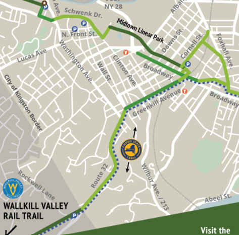
Starting from the Rockwell Lane Parking Lot [Northern End]; Map Board. A stone dust trail travels North, where it connects to the Wallkill Valley Rail Trail at Route 32.
Note; Across Route 32, the old rail bed is no longer accessible, so to connect to the Kingston Greenline , North, in Kingston, requires an on-road detour. See; Map Below.
From Route 32 in Kingston; The stone-dust Wallkill Valley Rail Trail travels Southwest, along the old rail bed, quickly crossing Rockwell Ln, where the trail follows a wooded corridor. Cross Dewitt Mills Rd at 2.3 miles and travel through a tunnel underneath I-87 and alongside Hickory Bush Rd at 3 miles. Cross Hickory Bush Rd at 3.6 miles, where you'll find a Map Board, before a causeway takes you across Williams Lake. Pass by an old quarrying pit (first of several you'll pass). On a hot day these old mines allow cool air to flow up onto the trail. It will feel like you are passing by an A/C. You'll travel above Forth Lake, as the trail turns South, at 4.2 miles. You'll pass by several more old quarrying pits, as well as, old Cement Works remnants. Informational signs are located along the trail. Travel alongside Williams Lake Rd, across which is Fifth Lake. You'll come alongside Binnewater Rd and cross Breezy Hill Rd at 5.3 miles. Pass more old quarrying pits as you follow a ridge above Binnewater Rd, before crossing a bridge and coming to a Spur Trail on your right at 5.9 miles.
Note; This Spur Trail will take you down to Binnewater Rd, across which is the Binnewater Road parking lot & brick & stone cement Limewater Kiln at the back of the parking lot.
Cement rock was first discovered in the region in 1825 at High Falls by engineers working on the Delaware & Hudson Canal. Prior to this time hydraulic cement used in the construction of the canal had been imported from Madison County, New York. Found to be a more high quality grade, High Falls cement was quarried and burned for use in the Canal. Other quarrying sites, at Lawrenceville, Hickory Bush, Whiteprint, and Rosendale, opened in ensuing years. The Rosendale Cement Works near Limewater employed 5,000 workers and produced 4,000,000 barrels of cement a year at the peak of its activity at the turn of the century. Rosendale cement was used in the Brooklyn Bridge, the pedestal of the Statue of Liberty, the U.S. Treasury Building, as well as in many other structures around the country. The development of Portland cement in 1920 marked the decline of the Rosendale Cement Works. Population of the region dwindled by the 1940's and rail service was reduced. Rosendale quarrying pits and cement kilns were located just North, of the Rosendale RR Station and South, of the Fifth Limewater Lake. One of the distinctive features of the local landscape is a chain of five small lakes known as Limewater, numbered one through five, North to South.
Continuing along the ridge, you'll quickly come to the Rosendale RR Trestle. This restored 940 foot trestle bridge crosses 150 feet above Readout Creek with wide open vistas of the surrounding hills. Cross Mountain Rd where you'll find a Map Board, before passing through a small rock cut and re-entering the woods. Mile Markers are placed every 0.5 miles. There is a brief split in the trail which then merges back together. You'll pass by the RAIL TRAIL CAFE before crossing a bridge over River Rd at 7.9 miles. At 9.2 miles you come to a road crossing and the New Paltz section of the trail. Signboards are located at all road crossings with the name of the road and a Map on the back. After crossing over Cragswood Rd at 10.1 miles, there are more open fields and a nice view of the ridgeline on your right. Cross over Springtown Rd and you'll come to the Wallkill River Bridge at 11.1 There are built in benches and a great view. The trail then heads back into the woods along a berm. After crossing another road you'll pass by an old RR Measured Mile Pole. + See; RR Measured Mile Pole Below. It says "Measured Mile" on one side and 1 mile on the opposite. You'll pass two more of these poles for a ½ mile and a ¼ mile. After crossing over Huguenot St at 12.1 miles, there will be a platform on the right overlooking a marsh. Pass an old RR Whistle Post on your left. + See; RR Whistle Post Below. The trail is now residential as it crosses Mulberry St and comes to the Henry W. Dubois Greenway Connector on your left at 12.8 miles.
Note; The Henry W. Dubois Greenway Connector is part of the Empire State Trail and connects to the Hudson Valley Rail Trail . The paved trail takes you East, up to and across Chestnut St to Henry Dubois Dr. Here, a 2-Way SEPARATED BIKE LANE take you up a slight hill to Putt Corners Rd, where a BIKE LANE travels right, South, to Route 299 and the start of the Hudson Valley Rail Trail after 1.5 miles. This trail travels East, connecting to the Walkway Over the Hudson .
After a couple of street crossings, you'll by the old New Paltz Train Station in downtown New Paltz and cross *Main Street (Route 299) at 13.3 miles.
Note; Heading right, West, down Route 299 will bring you to an overlook of the Wallkill River and the start of the River to Ridge Trail. See Below.
Cross Plains Rd at 13.6 miles.
Note; Right, a pedestrian bridge leads to the Sojourner Truth Park parking lot. Map Board, picnic tables & boat launch for Wallkill River. Kayak rentals.
A meandering creek follows below along your right and power lines are up to your left. The trail is more open and thus less shaded. You cross Cedar Ln, before a bridge over another creek at 15.1 miles, with good views of the ridgeline. Travel through an apple orchard, before crossing Old Ford Rd at 16.1 miles. Cross Bridge Creek Rd, before crossing a bridge over Forest Glen Rd at 17.1 miles. Cross Phillips Hill Rd, as you cross into Gardiner at 17.9 miles. Cross Main St (Route 44) in downtown at 19 miles. 2nd Street Parking lot, Map Board and food are available here. Exit town and head back into the woods. Cross Sand hill Rd at 20.1 miles. The trail then ends after 21.5 miles at Dennison Road.
Note; An on-road Detour is necessary to connect to the Walden-Wallkill Rail Trail further South, because a correctional facility, has been erected on a portion of the old rail bed. Turn right, West, on-road along Dennison Rd and then a left, South, when you reach Sand Hill Rd. At the end of this road turn left, East, along Galesville Rd and merge straight onto River Rd. When the road turns to gravel by McKendrick Rd to your left, head right, South, to rejoin the old rail trail after 2.3 miles. See: Walden-Wallkill Rail Trail .
River to Ridge Trail:
The Open Space Institute and others created the River to Ridge Trail, which meanders through farm fields and over gently rolling hills, connecting New Paltz directly to the SHAWANGUNK RIDGE and 90 miles of recreational carriage roads and trails at the MOHONK PRESERVE and MINNEWASKA STATE PARK PRESERVE . The Lower Section is mostly flat, while the Upper Section contains hills. The Mohonk Preserve Section Loops around the preserve and contains some hills. A Day Use Pass is required for the Carriage Road Trails in the preserve, but I don't believe you need one on the R2R Trail, as the Map says "Day Pass beyond this point" which does not include the R2R Trail.
Starting from the intersection of *Main Street and the Wallkill Valley Rail Trail in New Paltz [Eastern End]; Travel West, down Main St (Route 299) to the Wallkill River Bridge. A promenade with informational boards and Map overlooks the river here at the start of the River to Ridge Trail. Cross the bridge over the river and head right, North, along the crushed gravel Lower Section at 0.1 miles. Pass another Map Board as the trail travel around open fields and alongside the river. Cross a small stream before coming to a shaded tree grove at 0.7 miles with some picnic tables overlooking the river. The trail then pulls away from the river, South, back through open fields. Come to an intersection and head left.
Note; Right brings you to the Springtown Road parking lot. You can also rent bikes here. See; NEW PALTZ BIKING .
Come to another Map Board and BIKE STATION. Crosswalk over Springtown Rd. The trail continues around an open field head in West, with little shade. Cross Lewis Lane at 1.6 miles. Here you'll start the Upper Section which heads uphill. Travel up and over the hill before passing by the Lower Loop Intersection at 1.8 miles and continuing straight. You'll Loop back to here. Cross a bridge and continue uphill. Come to the Upper Loop Intersection at 2.4 miles. Great views of the Shawangunk Ridge. Granite seating.
Note; Heading left East, the trail travels downhill, Looping back to the Lower Loop Intersection at 3 miles. Return the way you came for a 4.8 mile Short Loop.
Right, the trail continues West, downhill to Butterville Rd at 2.7 miles. Cross the road and enter the Mohonk Preserve.
Note; The trails in the Mohonk Preserve require a Day Use Pass, however, this section is still along the River to Ridge Trail and the map says "Day Pass beyond this point" which does not include the R2R Trail.
The wide crushed gravel River to Ridge Trail crosses over Kleine Kill before coming to *Pine Road. Start of the 2nd Loop. Travel right, on-road along Pine Road (low traffic) to the base of the Shawangunk Ridge. A short steep climb is required. Come to a Map Board and green gate on your left at 3.4 miles.
Note; Straight leads to the Pine Road parking area (Fee) and access to the Mohonk Preserve Carriage Road Trails (Fee).
Head left past the gate along the crushed gravel White Oak Path. Come to another intersection and Map Board, turn left East, on-road along Lenape Lane (low traffic). Travel through open fields. Come to the 2nd Loop Intersection on your left at 4.4 miles. This is where you Loop back.
Note; Before Looping back continue straight, East, along the Testimonial Gateway Spur. A bridge will take you over Butterville Rd and along the wide crushed gravel trail through a canopy of trees surrounded by open fields. Benches, informational boards. Pass by a gazebo on your right before passing through the arch of the stone 1907 Testimonial Gateway. The trail ends ahead at Gatehouse Rd, so turn right to reach the Testimonial Gateway parking lot after 0.7 miles. Restrooms, Map Board, BIKE STATION.
After checking out the Testimonial Gateway Spur [1.4 mile round trip] head North, from the 2nd Loop Intersection along the trail as it winds through the fields & woods along a hilly route. This returns you to *Pine Road, completing the 2nd Loop after 4.9 miles. Return back across Butterville Rd East, returning to the Upper Intersection at 5.3 miles. Here you can return via the trail on your right back to the Lower Loop Intersection at 5.9 miles. Return back to the Wallkill Valley Rail Trail after a 7.7 mile Loop [9.1 mile Loop including Testimonial Gateway Spur].
Old Railroad Equipment:
+
RR Whistle Post:
The Whistle Post, was a post with a
large "W" engraved or painted on it. This meant the railroad
engineers were to start sounding the trains Whistle. The Whistle posts
were usually placed 0.25 miles
in advance of a road crossing,
bridges, tunnels and other points. Usually, there would be a post placed on both
sides of the crossing, covering both directions.
+ RR Measured
Mile Pole:
A RR Measured Mile Pole was
utilized by the RR to
precisely measure a
1 mile segment,
used to calibrate train speedometers and odometers
. These segments are marked with signs
or markers,
often
with a distinctive appearance (e.g., red painted tops) to indicate that it's a
"measured mile", at
the beginning and end, allowing engineers to accurately determine train speed by
timing how long it takes to travel the measured distance.
HH
CLICK HERE FOR WALLKILL VALLEY RAIL TRAIL MAP
CLICK HERE FOR HUDSON VALLEY RAIL TRAIL MAP
CLICK HERE FOR RIVER to RIDGE TRAIL MAP
CLICK HERE FOR KINGSTON GREENWAY MAP
CLICK HERE FOR EMPIRE STATE TRAIL MAP
BEFORE YOU SET OUT BE SURE TO READ THE
WAIVER OF RESPONSIBILITY AND DISCLAIMER
BIKE IT OR HIKE IT