WALDEN-WALLKILL RAIL TRAIL:
WALDEN-WALLKILL, NEW YORK
-BIKE IT OR HIKE IT-
Last Updated: July 25, 2025
Length: Walden-Wallkill Rail Trail; 4.7 miles
Difficulty: Walden-Wallkill Rail Trail; Southern Section; Easy. Flat, paved rail trail.
Walden-Wallkill Rail Trail; Northern Section; Moderate. Flat, hard packed dirt & grass rail trail.
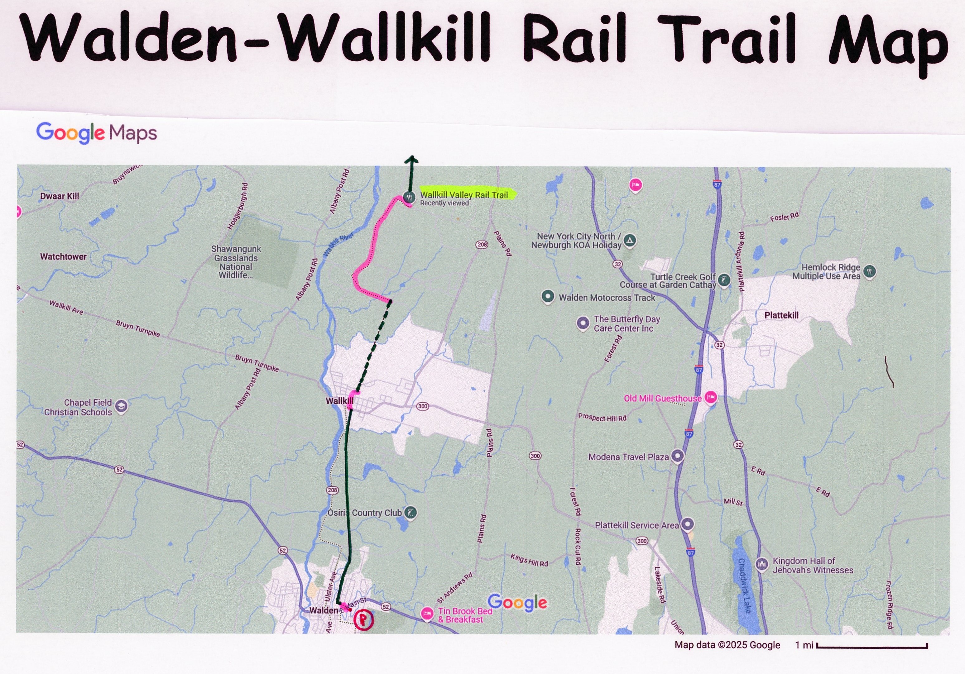
Directions:
To start from Wooster Memorial Grove Park in Walden [Southern End]; From I-84 take exit 28 to Route 208 north to Walden. Turn right on Route 52 (E Main St) and look for Wooster Memorial Grove Park on your right. Park here for trail.
To start from Wallkill [Northern End]; From I-84 take exit 28 to Route 208 north to Bona Venture Ave in Wallkill. Head right, then a quick left along Park Ave for parking. Trail starts on south side of Bona Venture Ave.
The Walden-Wallkill Rail Trail, also known as the Jesse McHugh Rail Trail, runs along the former rail bed of the Wallkill Valley Railroad. In the late 19th century, the Wallkill Valley Railroad ferried fresh produce and vegetables from the farmlands of Ulster County to the streets of New York City. It also served as a commuter railroad for passengers traveling along the Hudson Valley. For more than a half century, the railroad supported business and tourism, provided jobs and created a critical economic link between upstate and downstate. By 1933 only one passenger train ran daily each way, and four years later, all passenger service came to a halt. Over the next few decades, numerous stations along the Wallkill line closed. In 1977, the Wallkill Valley Railroad took its last freight run. The trail travels North, from Walden to Wallkill, where you can connect to the Wallkill Valley Rail Trail via an on-road detour. For more information visit; WALDEN-WALLKILL RAIL TRAIL .
Walden-Wallkill Rail Trail; Southern Section:
Starting from Wooster Memorial Grove Park in Walden [Southern End]; There is an old train station in the park that appears to hold some type of Welcome Center, as well as, an open pavilion. Exit the park out to E Main St,, following signs for the trail, by heading left, on-road, to a cross-walk over E Main St. Travel on-road, up Woodruff St to its end. Straight ahead is a "Lombardo Street" type path (think San Francisco) that winds it's way down to the start of the Walden-Wallkill Rail Trail; Southern Section after 0.2 miles. A Map Board is located here.
[Re-zeroing mileage] The paved Walden-Wallkill Rail Trail travels North, along a berm through the woods, with Tin Brook below on your left. White Mile Markers are painted on the trail every 0.25 miles. Pass by the Kimball Park parking lot before crossing Lake Osiris Rd after 0.8 miles, where the trail opens up. You cross the Walden/Wallkill town line at 2.2 miles. The paved trail ends after 3 miles at Bona Venture Ave. Another Map Board located here.
Note; Straight, the old rail bed becomes part of Railroad Ave. To connect to the Walden-Wallkill Rail Trail; Northern Section, head left, then right, North, on-road (low traffic/sidewalk available) along Park Ave (Parking available along Park Ave). Pass by Wallkill Town Park (Playground & sports court) on your left and turn right on Bridge St, then left on Railroad Ave, passing more sports fields along your right. At the end of Railroad Ave, where the road turns sharp right, you'll pick up the Walden-Wallkill Rail Trail; Northern Section, after 0.4 miles [3.4 miles Total].
Walden-Wallkill Rail Trail; Northern Section:
The narrow, hard packed dirt & grass trail Wallkill Rail Trail; Northern Section travels North, along the old rail bed. [Continuing Mileage] It follows along a shaded corridor between fields. You come to River Road after 4.7 miles and the end of the trail. The rail bed continues straight, but is not accessible.
Note; To connect to the Wallkill Valley Rail Trail, which travels North, through New Paltz, you'll need to use an on-road detour. Turn left, on-road, along River Rd (low traffic) and bare right along Galeville Rd. Turn right on Sand Hill Rd (busier road) and follow to Denniston Rd on your right. Turn right and you'll come to the start of the Wallkill Valley Rail Trail on your left after 2.4 miles.
HH
CLICK HERE FOR WALDEN-WALLKILL RAIL TRAIL MAP
CLICK HERE FOR WALLKILL VALLEY RAIL TRAIL MAP
BEFORE YOU SET OUT BE SURE TO READ THE
WAIVER OF RESPONSIBILITY AND DISCLAIMER
BIKE IT OR HIKE IT