SHORELINE GREENWAY TRAIL:
NEW HAVEN-MADISON, CONNECTICUT
-BIKE IT OR HIKE IT-
Last Updated: September 20, 2026
Length: New Haven Section; 2.3 miles
New Haven; East Shore Section; 4.4 miles [to be constructed]
East Haven Section; 1.6 miles
Branford Section; 2.5 miles
Madison Section; 1.3 miles
Hammonasset Beach SP Trail; 2.5 miles
Difficulty: New Haven Section; Easy. Flat, paved, stone-dust and 2 WAY SEPARATED CYCLE TRACK.
New Haven; East Shore Section; [to be constructed]
East Haven Section; [Heading West] Easy. Flat stone-dust trail.
East Haven Section; [Heading East] Moderate. Narrow, hard packed dirt & gravel trail along with a wide, flat gravel road. Mt bike a must.
Branford Section; [Birch Road Section] Easy. Mostly flat, hard packed gravel & stone-dust trail.
Branford Section; [Tabor Property Section] Easy. Paved flat trail.
Branford Section; [Young's Pond Park Section] Moderate. Mostly flat, hard packed dirt & grass trail.
Branford Section; [Trolley Trail] Easy. Flat, hard packed gravel trail.
Madison Section; Easy. Mostly flat, wide stone-dust trail with a short boardwalk.
Hammonasset Beach SP Trail]; Easy. Flat, paved trail.
Directions:
For the East Haven Section [Western End]; From the intersection of Routes 1 & 142 in East Haven take Route 142 south for 1.7 miles. Turn right on Mansfield Grove Rd, then take your second right on Hoop Pole Lane. The trail parking lot is right on the corner.
For the Branford Sections [Center Section];
For the Tabor Drive parking lot; From I-95 take exit 54 to Cedar St south. Turn left on Route 146 and follow for almost a mile. Turn left on Tabor Drive and travel 0.5 miles to the parking lot on your left.
For the Trolley Trail Section; From I-95 take exit 55 to Route 1 south. Turn left on Windmill Hill Rd, then left at Damascus Rd. Continue along Damascus Rd until the road splits. Bear right Totoket Rd and follow for 1.1 miles.
Turn left down Tilcon Rd to the Tilcon Road parking lot.
For the Madison Section [Eastern End]; From I-95 take exit 62 to Route 450 south to Route 1. Straight ahead is the entrance to Hammonasset Beach SP [Fee]. Head left along Route 1 and take your first right between two large yellow gates to the gravel Hammonasset Beach SP (Route 1) parking lot. No Fee. Start of both the Shoreline Greenway Trail and Hammonasset Beach SP Trail.
The Shoreline Greenway Trail is a proposed trail along the Connecticut Shoreline that will extend from the West Haven/New Haven border East, through New Haven, South, through New Haven; East Shore to East Haven, then East, through Branford and Guilford to Hammonasset Beach State Park in Madison. Also in Madison you can connect to the Hammonasset Beach SP Trail off the Shoreline Greenway Trail. For more information visit; SHORELINE GREENWAY TRAIL .
Shoreline Greenway Trail; New Haven Section:
Starting from the intersection of Ella T Grasso Blvd & Kimberly Ave (Route 122) by the West River (no parking available) [Western End];
Note; You can connect to the SAVIN ROCK TRAIL in West Haven via an on-road route. Travel South, on-road along Kimberly Ave (no shoulder/sidewalk available) over the West River. Turn left along 1st Ave (residential) and come to Monahan Pl, next to the West Haven Boat Launch after a 1.2 mile detour.
The wide, paved Shoreline Greenway Trail; New Haven Section travels East, alongside Ella T Grasso Blvd to a traffic circle past which you'll continue on-road along Sea St (residential). Cross Howard Ave at 0.4 miles.
Note; You can connect to the West River Greenway from here via the Howard Ave BIKE LANE. I have not checked out this trail yet.
Come to the Sound School facility and head left, North, along the school road, past Bayview Park. On your right, just before the Blvd Pump Station, you'll pick up a briefly paved trail at 0.7 miles. The now stone-dust Long Wharf Nature Preserve Trail travels Northeast, through the preserve, before coming to Long Wharf Dr. A wide sidewalk brings you to the Vietnam War Veteran Memorial Monument at 1 mile. Here, the paved Long Wharf Park Trail winds through this narrow park along the New Haven Harbor which contains some benches, a few Porto-Potty's, tons of food trucks and not much else.
Note; Long Wharf Park is slated to be rebuilt in the future and will include new Paths & Trails.
Pass by several parking lots before coming to the Visitors Center parking lot at 1.6 miles. Here you can utilize the Long Wharf Drive 2 WAY SEPARATED CYCLE TRACK. Pass by Long Wharf Pier (The Schooner's Freedom Amistad & Quinnipiack are sometimes berthed at Long Wharf Pier). You can head out to the end of the pier where you'll get good views of the New Haven Harbor & Terminal as well as the monument atop East Rock Park to the North. Pass by the red "Boathouse at Canal Dock" sign at 1.8 miles.
Note; This is roughly the start of the Farmington Canal Heritage Trail, which starts across the road.
The Long Wharf Drive 2 WAY SEPARATED CYCLE TRACK continues past the Canal Dock Boathouse.
Note; You can travel out along the Canal Dock Boathouse pier where the history of the harbor is shown.
The Canal Dock Boathouse was constructed from the remains of the old George Adee Memorial Boathouse, which was built in 1911 and served as the home of the Yale University crew teams. It was razed in 2007 to make way for the new Pearl Harbor suspension Bridge over the Quinnipiac River.
Soon you head inland along the East Street 2 WAY SEPARATED CYCLE TRACK which brings you to Water St after 2.3 miles where you'll pick up the Water Street Bike Path.
Note; Left, West, along the Water Street Bike Path, will bring you to Brewery St where you can connect to the Farmington Canal Heritage Trail.
New Haven; East Shore Section:
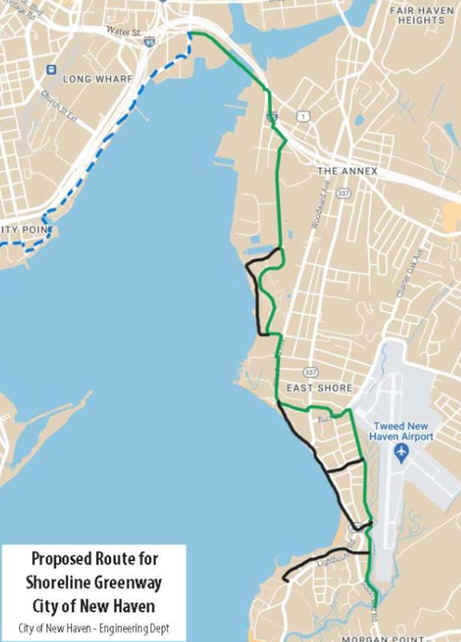
New Haven is planning to construct a 4.4 mile section of the Shoreline Greenway, from the East Street 2 WAY SEPARATED CYCLE TRACK/Water Street Bike Path, South, to *South End Road in East Haven. Under design in 2026. In New Haven, both the East Street SEPARATED BIKE LANE & Water Street Bike Path connect to the Farmington Canal Heritage Trail; Southern Section . See; Map Below.
East Haven Section:
Starting from the Hoop Pole Lane parking lot [Western End]; You'll find a Map Board located here:
Heading Southwest; Follow the stone-dust Shoreline Greenway Trail into the woods. Just past a huge boulder the trail splits at 0.2 miles.
Note; A hard packed dirt Spur Trail takes you South, 0.1 miles, out to the Bradford Preserve.
Continue right, Northwest, where the trail takes you through the woods, then past the D.C. Moore School to Elliot St at 0.3 miles.
Note; The trail has been extended West, to Coe Ave, then South, to Bradford Ave, where you can access Cosey Beach Park (splash pad) after 1 mile. I have not checked out this section. I believe it involves BIKE SHARROWS (on-road) and sidewalks. The trail will then be extended West, 1.3 miles to *South End Road in New Haven.
Heading East; Travel past the Map Board out to Mansfield Grove Rd and turn left, on-road, for a short hop to Pevetty Dr on your right. Travel on-road (residential) to the end of this road at 0.2 miles. Just past the large boulders is a narrow, hard packed dirt & gravel trail that enters the Farm River State Park. Watch for the "green" Shoreline Greenway Trail tags to help you navigate through the woods. Head right at 0.3 miles along a wide gravel road (Brown Rd) This travels alongside the Farm River Marsh. The gravel road splits at 0.5 miles. Head left. You'll come to a hiking sign on your left.
Note; The Shoreline Greenway Trail heads left, North, however, if biking I would continue straight along the gravel road which brings you out to the paved Browns Rd at 0.6 miles. You can follow this road left out to Short Beach Rd at 0.7 miles. This is where an on-road section of the trail continues right, East, across a bridge over the Farm River to the Short Beach section of Branford after 0.8 miles. Scenic.
Heading left, North, at the hiking sign, a hard packed dirt & gravel path heads uphill into thick woods. A bit hilly with some tree roots. Cross a few small bridges and climb a steep hill before coming to a picnic table at 0.8 miles. Head left as the trail widens before reaching the Farm River SP parking lot off Short Hill Rd at 1.3 miles.
Note; The Shoreline Greenway Trail continues right, East, on-road along Short Hill Rd. Cross a bridge over the Farm River to the Short Beach section of Branford after 1.7 miles.
Branford Section:
Note; A 4.1 mile on-road route Northeast, will take you to the Tabor Drive parking lot. See; Map. In 2023 the town engineer is working on plans for completing Branford’s section from the East Haven line, with sidewalks and BIKE LANES or BIKE SHARROWS along Route 146, Maple Street, and Indian Neck Ave. It is hoped that this might connect with the boardwalk along the Branford River, which brings you to Tabor Dr. You then follow Tabor Dr to the Tabor Drive parking lot.
Starting from the Tabor Drive parking lot [Western End]; Map Board. This section has changed some since I was last here.
Note; Just past the parking lot, a 0.5 mile trail has been built South, to connect the Shoreline Greenway Trail to Ecology Park, with its 360-degree views of the surrounding area, including Long Island Sound.
The wide paved Shoreline Greenway Trail travels East, through the Tabor property along an open corridor. (I believe the trail now travels South, of Chet's Pond) Travel alongside Chet's Pond (Branford Labyrinth located here) before following the active rail line on your left out to Pine Orchard Rd where a crosswalk leads to a wooded section at 0.7 miles. Here the trail consists of hard packed gravel & stone-dust as it winds its way through the woods. Come to the Birch Road parking lot at 1.1 miles. Map Board here. Cross over Birch Rd and you'll come to an intersection in Young's Pond Park at 1.2 miles. Turn right, South, along a wide, hard packed dirt & grass trail. Wetlands along your right and rock ledge along your left. Ignore any side trails. The trail will then turn sharply to the left where it Loops back through the park. Just past a chain-link fence will be a narrow dirt trail on your right. Follow this trail (one rocky section) down to Young's Pond and head right around the Southern Tip of the pond. Notice all the upright slabs of stone ringing the pond. Right brings you out an old stone entrance to the Blackstone Ave parking area (space for a couple of cars) after 1.7 miles. A sign on the stone face reads "Bob's Woods".
Note; To connect to the Trolley Trail [Continuing Mileage] turn left and travel North, on-road, along Blackstone Ave (narrow road with no shoulders). A golf course runs along your right and Young's Pond Park along your left. Turn right, South, down Totoket Rd and you'll come to Tilcon Rd on your left after 2.4 miles, where you'll pick up the Trolley Trail. Here the hard packed gravel trail follows the old rail bed East through the woods to the Tilcon Road parking lot at 2.5 miles.
Starting from the Tilcon Road parking lot; [Continuing Mileage] Map Board located here. Cross the Tilcon RR tracks and continue East, along the hard packed gravel Trolley Trail. Very scenic with Osprey nesting platforms as you travel along a causeway through the Pine Orchard Wildlife Marsh. A narrow cement walkway (Walk bikes if you encounter pedestrians) leads across a bridge to a wooded section. Travel through a rock cut and underneath Pleasant Point Rd before crossing an old iron Trolley Bridge over a tidal creek via a narrow wooden walkway (Walk bikes if you encounter pedestrians). Long Island Sound & Thimble Islands to your right. Come to the West Point Rd parking lot after 3.2 miles. Straight will take you out to Thimble Island Rd.
Gilford Section:
No trails have yet been built.
Madison Section:
Shoreline Greenway Trail:
Starting from the Hammonasset Beach SP (Route 1) parking lot [Northern End]; Map Board located here.
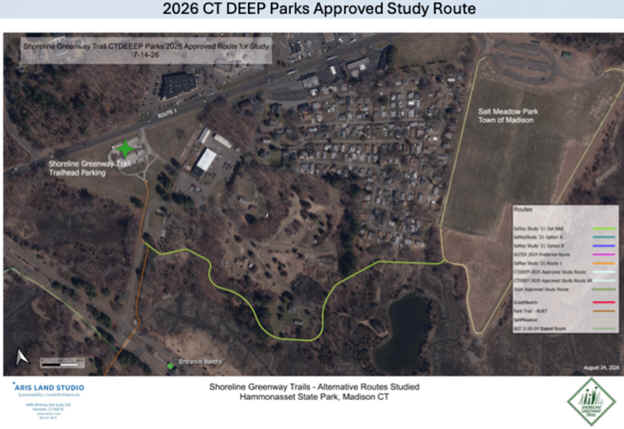
Note; The trail is proposed to be extended East, 0.5 miles to Salt Meadow Park. See; Map Below.
Follow the wide paved Shoreline Greenway Trail South, out alongside the service road to the Hammonasset Beach SP Entrance Road. Here a cross-light gets you across this busy road at 0.2 miles. Left is the entrance to HAMMONASSET BEACH SP.
Note; The Shoreline Greenway Trail heads right, Northwest, while the Hammonasset Beach SP Trail continues straight, South. See Below.
Heading right, Northwest, from the Hammonasset Beach SP Entrance Road; The stone-dust Shoreline Greenway Trail brings you to a boardwalk which takes you over a small tidal marsh and into the woods. You travel alongside the Northern Border of the park, past campgrounds, before pulling briefly alongside Route 1. The trail then travels alongside the Toms Creek Tidal Marsh before ending at Webster Pt Rd and Liberty St after 1.3 miles. Map Board.
Hammonasset Beach SP Trail:
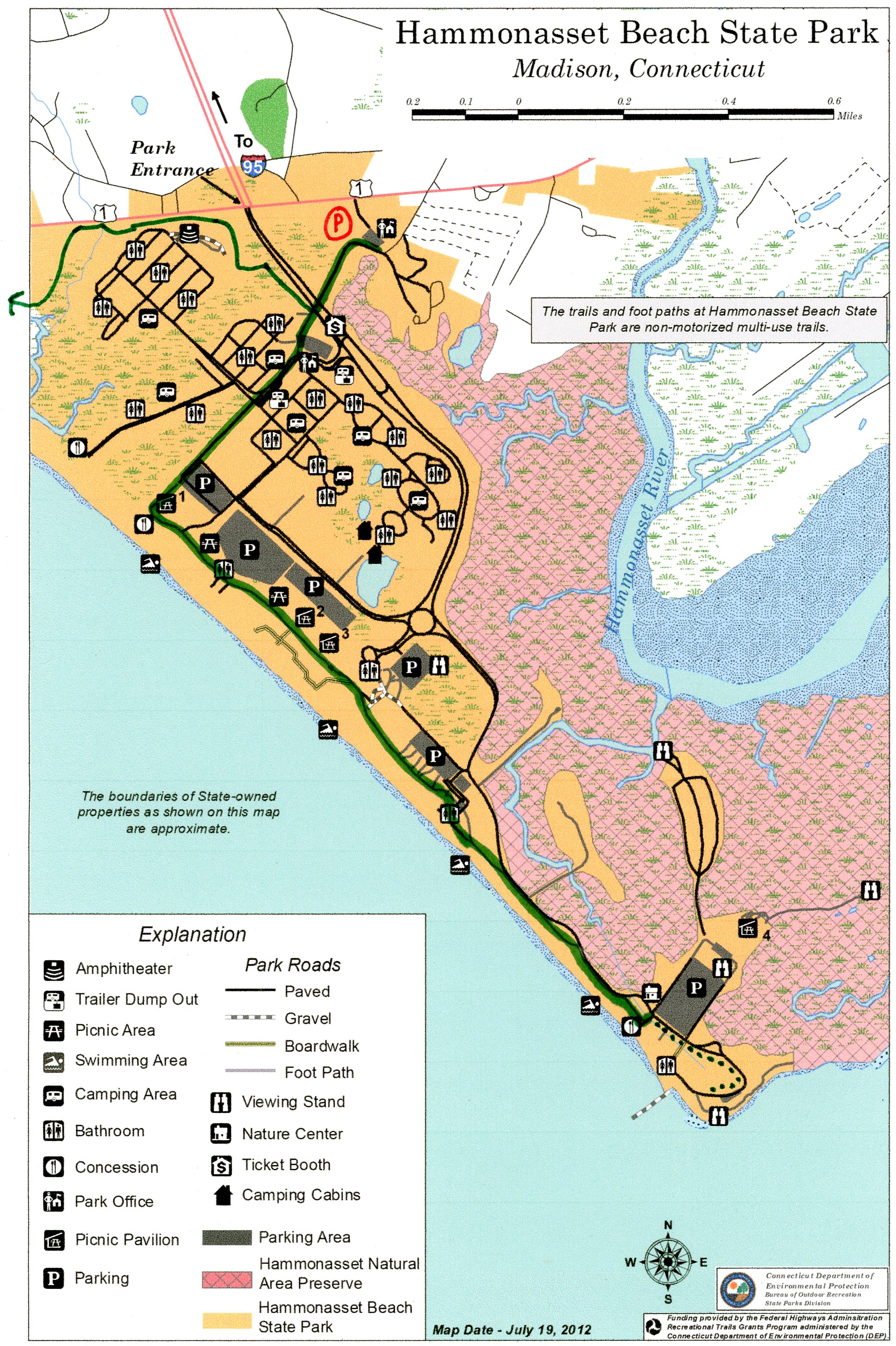
Heading straight, South, from the Hammonasset Beach SP Entrance Road, the wide paved Hammonasset Beach SP Trail continues into the Park past the campgrounds. Restrooms, water fountains available all along the route. Pass a playground where you'll find a Map Board. After 0.7 miles the trail turns Southeast, following the shoreline and beaches (blocked by sand dunes). Picnic pavilions and bath houses along the route. Access to beach. Travel alongside the Hammonasset Natural Area Preserve before the paved trail ends after 2.1 miles at Water Way, across from the MEIGS POINT NATURE CENTER and parking lot.
Note; You may continue right, alongside Water Way via a narrow stone-dust trail that circles around a small pond, before bringing you to a parking lot at Meigs Point. Nice natural views of Long Island Sound up a short path. Past the parking lot you'll Loop back Northwest, to another bath house at 2.5 miles. This is as far as you can travel by bike.
HH
CLICK HERE FOR SHORELINE GREENWAY TRAIL MAP
CLICK HERE FOR YOUNG'S POND PARK MAP
CLICK HERE FOR HAMMONASSET SECTION MAP
CLICK HERE FOR HAMMONASSET BEACH SP TRAIL MAP
BEFORE YOU SET OUT BE SURE TO READ THE
WAIVER OF RESPONSIBILITY AND DISCLAIMER
BIKE IT OR HIKE IT