FARMINGTON CANAL HERITAGE TRAIL; SOUTHERN SECTION:
NEW HAVEN-SOUTHINGTON, CONNECTICUT
-BIKE IT OR HIKE IT-
Last Updated; September 20, 2026
Length: Farmington Canal Heritage Trail; Southern Section; 26.3 miles
Difficulty: Easy. Flat, paved rail trail.
Directions:
To start from Southington [Northern End]; From I-84 take exit 30. Eastbound; Come to Atwater St. Westbound; Come to Marion Ave and head left underneath the highway where you'll come to Atwater St.
For the Summer Street parking lot; Continue east on Marion Ave which turns into W Main St. As you enter the town turn left on Summer St where you'll find parking on your right.
For the Canal Street parking lot; Travel south on Atwater St
which turns into Canal St. After crossing Route 322, the parking lot will be on your left.To start from Cheshire [Central Section];
Take Route 10 to Cornwall Ave (just south of the junction of Routes 10, 68 and 70). Go west down Cornwall Ave for seven-tenths of a mile. A parking lot is located on the left, just past the trailhead.To start from Hamden [Central Section]; Take Route 10 to Sherman Ave in Hamden, just south of the Sleeping Giant SP entrance. The parking lot is just down the road on the left.
To start from New Haven [Southern Section]; You can access the trail from the Metro-North's State Street Station. For more information visit; Metro North Railroad . If you click on the individual stations, they have available both directions and maps.
To start from the Long Wharf Pier Park parking lot or Canal Dock Boathouse in New Haven [Southern End]; From I-95 take exit 46.
Northbound; Come to Long Wharf Drive and head left alongside Long Wharf Park. The parking lot is located at the Pier, with additional parking next to the Visitor Center at the Park. Just east up Long Wharf Drive is the Canal Dock Boathouse with on street parking across from it.
Southbound; Come to Sargent Dr and head left. Turn left on Wharf Drive and follow alongside Long Wharf Park. The parking lot is located at the Pier, with additional parking next to the Visitor Center at the Park. Just east up Long Wharf Drive is the Canal Dock Boathouse with on street parking across from it.
The Farmington Canal Heritage Trail is a paved multi-use trail that extends from New Haven North, to the Massachusetts border. It follows the path of the former Farmington Canal and the New Haven & Northampton Railroad. Currently two sections are complete in Connecticut. The Southern Section travels from New Haven North, to Southington/Plainville. A Gap currently exists, as of 2026, through Plainville. The Northern Section is complete from Plainville/Farmington North, to the Massachusetts border. See; Farmington Canal Heritage Trail; Northern Section . In Plainville, the Beeline Trail will travel East, to New Britain, where it connects to the CT Fastrak Trail . In Massachusetts the Canal continued North, to Northampton and was known as the Hampshire & Hampden Canal. The paved trail continues North, through Massachusetts following the rail bed of the former New Haven & Northampton RR. In MA, unlike CT, the trail sections all have different names as you cross town borders. The first section is called the Southwick Rail Trail in Southwick, followed by the Columbia Greenway Rail Trail in Westfield. A Gap currently exists, as of 2026, between the towns of Westfield & Southampton before the paved trail continues North, through Easthampton and Northampton along the Manhan/New Haven & Northampton Canal Rail Trail . The trail then intersects at the "Spoke" where the Mass Central Rail Trail; Williamsburg Branch travels Northwest, towards Williamsburg and the Mass Central Rail Trail; Norwottuck Branch which travels East, towards Amherst. For more information See; FARMINGTON CANAL HERITAGE TRAIL .
Along the shoreline in New Haven, the Farmington Canal Heritage Trail starts from the Shoreline Greenway Trail, which travels from the West Haven border/West River Northeast, to Water St. Future construction will extend this trail South, through New Haven; East Shore to East Haven. See; Shoreline Greenway Trail .
The Farmington Canal Heritage Trail is part of the EAST COAST GREENWAY , a planned biking & hiking route stretching 3,000 miles from Maine South, to Florida. When complete it will traverse 15 states with a mostly off-road path.
Encouraged by the success of the 363-mile Erie Canal and looking for ways to more effectively compete with the port of Hartford, a group of New Haven businessmen met to discuss the idea of a Canal route from New Haven to the Massachusetts border and beyond. Representatives from seventeen towns met in Farmington, CT in January 1822 and persuaded the legislature to issue a charter for the formation of the Farmington Canal Company. At about the same time the Hampshire & Hampden Canal Company was formed in Massachusetts to extend the Canal from Southwick, MA North, to the Connecticut River in Northampton. In 1828, the Farmington Canal opened for excursion boats to take passengers from New Haven to as far as Northampton, Massachusetts. The Canal was 86 miles long, 4 feet deep and 36 feet wide. Twenty-eight Locks were built in Connecticut to accommodate a 292 foot total drop in elevation along the Canal. The Canal was never profitable and so by 1848 commercial operations on the Canal ceased. The New Haven & Northampton Railroad Co. was chartered in 1846. Dubbed the “Canal Line,” the first section from New Haven to Plainville was completed in 1847, mostly along the route of the Canal. By 1850 the line had been completed from Plainville to the Massachusetts border. See; NH & NH RR .
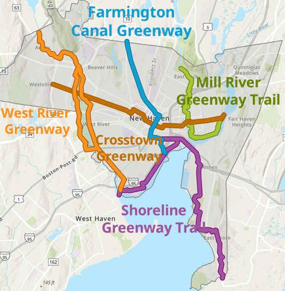
New Haven's planned interconnected Greenway Trails; Farmington Canal Heritage Trail (complete), Shoreline Greenway Trail (partially complete), West River Greenway (partially complete), Mill River Greenway Trail (partially complete) and the Crosstown Greenway (proposed). See; Map Below.
Shoreline Greenway Trail; New Haven Section:
Starting from the intersection of Ella T Grasso Blvd & Kimberly Ave (Route 122) by the West River (no parking available) [Western End];
Note; You can connect to the SAVIN ROCK TRAIL in West Haven via an on-road route. Travel South, on-road along Kimberly Ave (no shoulder/sidewalk available) over the West River. Turn left along 1st Ave (residential) and come to Monahan Pl, next to the West Haven Boat Launch after a 1.2 mile detour.
The wide, paved Shoreline Greenway Trail; New Haven Section travels East, alongside Ella T Grasso Blvd to a traffic circle past which you'll continue on-road along Sea St (residential). Cross Howard Ave at 0.4 miles.
Note; You can connect to the West River Greenway from here via the Howard Ave BIKE LANE. I have not checked out this trail yet.
Come to the Sound School facility and head left, North, along the school road, past Bayview Park. On your right, just before the Blvd Pump Station, you'll pick up a briefly paved trail at 0.7 miles. The now stone-dust Long Wharf Nature Preserve Trail travels Northeast, through the preserve, before coming to Long Wharf Dr. A wide sidewalk brings you to the Vietnam War Veteran Memorial Monument at 1 mile. Here, the paved Long Wharf Park Trail winds through this narrow park along the New Haven Harbor which contains some benches, a few Porto-Potty's, tons of food trucks and not much else.
Note; Long Wharf Park is slated to be rebuilt in the future and will include new Paths & Trails.
Pass by several parking lots before coming to the Visitors Center parking lot at 1.6 miles. Here you can utilize the Long Wharf Drive 2 WAY SEPARATED CYCLE TRACK. Pass by Long Wharf Pier (The Schooner's Freedom Amistad & Quinnipiack are sometimes berthed at Long Wharf Pier). You can head out to the end of the pier where you'll get good views of the New Haven Harbor & Terminal as well as the monument atop East Rock Park to the North. Pass by the red "Boathouse at Canal Dock" sign at 1.8 miles.
Note; This is roughly the start of the Farmington Canal Heritage Trail, which starts across the road.
The Long Wharf Drive 2 WAY SEPARATED CYCLE TRACK continues past the Canal Dock Boathouse.
Note; You can travel out along the the Canal Dock Boathouse pier where the history of the harbor is shown.
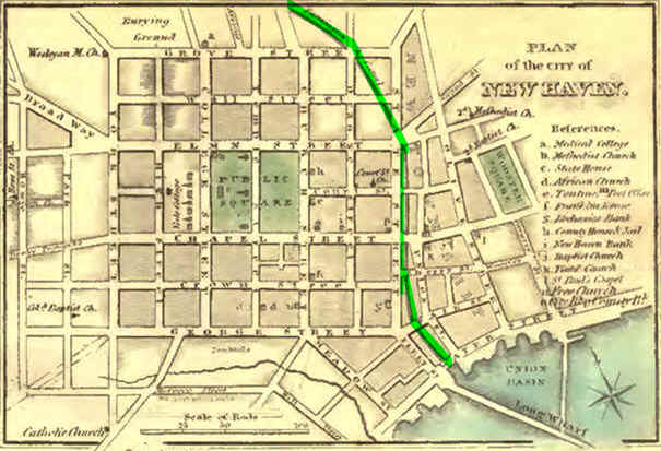
The Canal Dock Boathouse was constructed from the remains of the old George Adee Memorial Boathouse, which was built in 1911 and served as the home of the Yale University crew teams. It was razed in 2007 to make way for the new Pearl Harbor suspension Bridge over the Quinnipiac River. As you can see from the Map Below, the Farmington Canal (Green Line on Map) started from Water St between Union & State streets. This is where the current rail line is located. Over the years Union Basin was filled in creating the rail yards, Long Wharf area and I-95.
Soon you head inland along the East Street 2 WAY SEPARATED CYCLE TRACK which brings you to Water St after 2.3 miles where you'll pick up the Water Street Bike Path.
Note; Left, West, along the Water Street Bike Path, will bring you to Brewery St where you can connect to the Farmington Canal Heritage Trail.
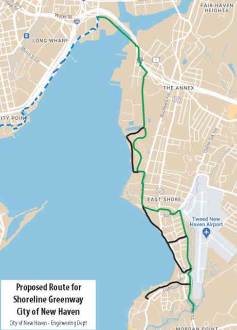
Note; New Haven is planning to construct a 4.4 mile section of the Shoreline Greenway Trail from the East Street 2 WAY SEPARATED CYCLE TRACK/Water Street Bike Path, South, to South End Rd in East Haven, as part of the Shoreline Greenway Trail . Design in 2026 and possible construction in 2027. See; Map Below.
Farmington Canal Heritage Trail:
Starting from Long Wharf Drive next to the red "Boathouse at Canal Dock" sign, in New Haven [Southern End];
Head Southwest, to the second cross-light over Long Wharf Drive. This leads to the paved Farmington Canal Heritage Trail which travels North, underneath I-95. Across the street is IKEA. The trail continues right alongside Sargent St, then Brewery St before traveling underneath Route 34. This brings you to Water St. Continue left, West, alongside Water St. Past Union St a 2 WAY SEPARATED CYCLE TRACK crosses a bridge over the RR tracks to State Street at 0.8 miles.
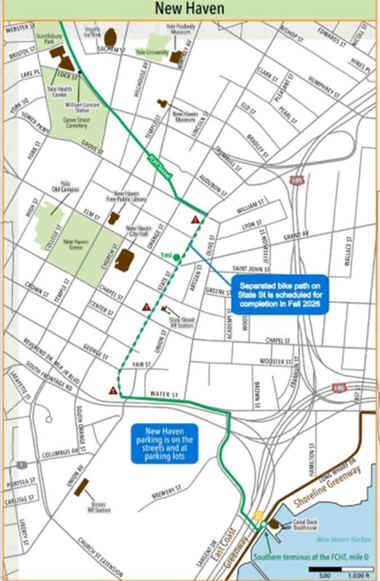
Note; Construction on the State Street 2 WAY SEPARATED CYCLE TRACK is expected to be completed Fall 2026. This will follow State St North, past the Metro-North's State Street Station, to Olive & Grove Streets at 1.4 miles. See; Map Below.
Here, a paved trail travels West, alongside Grove St and crosses Orange St, where the Farmington Canal Heritage Trail picks up on your right, just before the Grove Street Garage at 1.5 miles.
The Farmington Canal Heritage Trail travels Northwest, underneath the parking garage, along a sunken corridor.
Note; This tunnel carried the rail bed South, underneath the current FBI building and State St to the main rail line, however, because it traveled underneath the FBI building, that section was not utilized.
Pass by a ramp on your right, that leads up to Whitney Ave, before traveling through a tunnel under Whitney Ave. A series of LED screens give the history of the Canal & RR. You emerge out of the tunnel after passing under Temple St, where the trail continues below grade, traveling underneath Hillhouse Ave and coming to an intersection at 1.7 miles.
Note; Right, a paved Spur Trail will take you up to Hillhouse Ave in the center of Yale University. Check out the old historic brick buildings.
The trail then continues past Yale University buildings and underneath Prospect St, where you exit the below grade section. 911 Call System with cameras dot this section of trail. Pass by Scantlebury Park, where you'll find a Map Board, next to a RIDE NEW HAVEN station. This Bike Share program has locations throughout New Haven. Porto-Potty, BIKE STATION, playground, splash pad, sports courts and Skate Park. Also along this section are 2 Dioramas or 3-D boxes, one for the old RR and one for Lock 25. Cross Webster St, where the trail parallels Canal St. This urban section of trail contains multiple road crossings marked by large brownstone pillars. Cross Shelton Ave and pass through Newhallville Park, where you'll find picnic tables and a BIKE STATION. You then cross Hazel St at 2.9 miles, where you'll find some old RR tracks along the side. Cross Goodrich St at 3.4 miles as you leave New Haven and enter Hamden. Here several large trail signs hang over the trail. Again this urban section has multiple road crossings. The Hamden section has Mile Markers painted on the trail every 0.1 miles (unfortunately the trail is not uniformly marked through all the towns) along with informational boards. Cross an iron arched bridge over Putnam Ave at 4.1 miles. Here the trail is more wooded as you travel between a commercial/industrial corridor and Lake Whitney Open Space. Travel underneath Treadwell St followed by Mather St at 5.1 miles. Pass by an old RR Buffer Stop, + See; RR Buffer Stop Below, before traveling underneath Route 14 and crossing an old RR bridge over Connolly Pkwy at 6 miles. The trail then veers off the old rail bed around a commercial district before traveling through a tunnel under Skiff St, alongside Route 15 and back up to the rail bed at 6.7 miles.
Note; The Town Center Park Spur Trail on your right leads to a bridge across Shepard Brook into Town Center Park. A narrow paved trail then travels around the sports fields and up to the entrance road after 0.3 miles.
Cross an old RR bridge over Dixwell Ave, where a stone-dust jogging path follows the trail, followed by another bridge over Sanford St at 7.1 miles. Here the trail follows a wooded corridor paralleling Shepard Brook. Travel underneath Sherman Lane and across several small stone bridge crossings. The trail veers off the old rail bed again at 9.1 miles where it follows alongside Sherman Ave. Pass by the entrance for the Quinnipiac University York Hill Campus before coming to the Sherman Ave parking lot at 9.4 miles. Pick up the old rail bed again as you travel underneath Sherman Ave. Pass through a short deep rock cut and emerge at W Woods Rd at 10.1 miles.
Note; Right, East, across Route 10 and along Mt Carmel Ave brings you to SLEEPING GIANT SP .
Here the trail detours through a small shopping plaza before returning to the rail bed. Cross Todd Street where you'll find a parking lot at 10.4 miles. Porto-Potty and Map Board located here. Cross an iron bridge over Eaton Brook (look left to spot a separate bridge for the jogging path). Left the old Farmington Canal parallels the trail. Pass by the old Lock Keepers House at 11.2 miles. Lock 14 located here. Police substation here along with a Porto-Potty, water fountain, benches and Maps. Cross Shepard Ave, River Rd and Brooksvale Ave at 11.7 miles. Come to an intersection at 12.7 miles. Map Board located here.
Note; Left, over the bridge brings you to Brooksvale Recreation Park.
Continuing North, just before Mt Sanford Rd on your left spot an informational sign. Behind this is another old Lock 10?. After crossing Mt Sanford Rd you enter Cheshire. Mile Marker posts every 0.1 miles (not many left). Cross Willow Brook, where the Canal now contains water, before S Brooksvale Rd. Cross a bridge at 14.1 miles and you'll come to Lock 12 Park. Most well preserved Lock. Picnic pavilion, water fountain and museum and parking lot. Cross another bridge before coming to the main Lock 12 parking lot where you cross N Brooksvale Rd. Cross another bridge before Higgins Rd, then one last bridge before coming to the Cornwall Ave parking lot at 15.8 miles. Continuing the trail passes by a picnic area on your right (BIKE STATION) and more parking on your left. Site of old Lock. A couple of wide cement boardwalks take you through the wetlands for Willow Brook. You then pass by the Railroad Ave parking lot where you'll find a Map Board, restrooms, BIKE STATION and water fountain at 16.5 miles. The paved trail continues North, across Main St where you'll find another Map Board. Pass by an old RR abutment where the former Meridian, Waterbury Connecticut River RR line crossed. Informational signs located along the trail. You pick up the old Canal along your right with a promenade jutting into it at 16.8 miles. Pass by another old RR abutment where the former Cheshire Street Railway Streetcar line crossed before the trail comes to Jarvis St at 18 miles. Cross the road where the trail continues North, passing by the Jarvis Street parking lot at 18.1 miles. Bridge leads to the parking lot, restrooms and Map Board. Cross Sandbank Rd at 18.6 miles before passing by a large marsh. Cross Schoolhouse Rd at 19.4 miles followed by an old RR bridge over Tenmile River 19.9 miles. A second bridge takes you over W Johnson Ave followed by a third bridge over I-691. You cross into Southington and pass by some picnic tables before coming to the Canal Street parking lot after 20.5 miles. A Map Board and benches are located here. Yellow Mileage Markers are painted along this section every 0.5 miles. The trail then travels underneath the "New Haven-Northampton RR Canal Line" sign following an open industrial/residential corridor. Cross an old RR bridge over Route 322, then look to your left at 20.8 miles for the old red 1894 Milldale Train Station (Contains a museum, water fountain, picnic tables and a Porto-Potty). You'll next pass by the old Clark Brothers Bolt Company building (circa; 1854) that has been nicely refurbished. Just after you cross Burritt Street at 21.1 miles, a parking lot will be on your right. The trail travels underneath some on/off ramps for I-84, then comes alongside Canal St before crossing and traveling alongside Atwater St at 21.6 miles. The trail then pulls away from the road and travels through dirt fields before crossing over Eight Mile River and past a cement plant. You cross over W Main St at 22.4 miles and enter a commercial area. Places to eat. The trail continues North, past parking areas along Summer Street. Lots of nice murals painted along this section. After 23 miles you'll come to a bridge that crosses over the Quinnipiac River. There is an old RR Siding here, as well as benches. Two cross-walks will get you over Bristol & W Center Streets before you cross Center St, where the town has brick lined sidewalks, benches and lampposts. Just before you cross Mill St at 23.7 miles, look right to spot some benches, a water fountain, BIKE STATION and an emergency phone behind the Southington Water Dept. Next you'll pass by the Mill Street parking lot on your left at 23.8 miles. Porto-Potty. The trail follows the Quinnipiac River watershed along your left before entering a residential area and crossing Hart St and Cutriss St after 24.4 miles. The old RR tracks are still embedded in the road here. Cross a bridge over the Quinnipiac River then travel across a former "Superfund Site". Come to a Map Board and the Lazy Lane parking lot at 25 miles. Cross the road and follow the open corridor, crossing a bridge over the Quinnipiac River, before traveling underneath I-84 at 25.6 miles. Cross Spring St and soon come to Aircraft Rd after 26.3 miles and the current end of the trail.
Note; The next section to be completed will extend the trail North, to Town Line Rd and the Plainville border. However, as of 2026, the issue appears to be that the RR company will not sell or lease the old RR right of way.
Note; As of 2026, a Gap exists North, from Southington through Plainville to Farmington, where you connect to the Farmington Canal Heritage Trail; Northern Section , as well as, the Farmington River Rail Trail . A section is undeveloped in Southington from Aircraft Rd to Town Line Rd in Plainville. The Plainville section has been divided into 3 Phases. Phase 1, is currently under construction in 2026, will go from Town Line Rd to Norton Park and is planned to open Fall 2026. Phase 3, is currently in the planning stage, as of 2026 and will go from Norton Park to Route 72. Phase 2, is scheduled to begin construction Fall 2026 and will continue from Route 72 to Northwest Dr in Farmington.
Old Railroad Equipment:
+ RR Buffer Stop:
A RR Buffer Stop, is a device to prevent RR cars from going past the end of a physical section of track.
HH
BEFORE YOU SET OUT BE SURE TO READ THE
WAIVER OF RESPONSIBILITY AND DISCLAIMER
BIKE IT OR HIKE IT