GOFFSTOWN RAIL TRAIL:
GOFFSTOWN, NEW HAMPSHIRE
-BIKE IT OR HIKE IT-
Last Updated: November 25, 2024
Length: Goffstown Rail Trail; 5.5 miles
Difficulty: Easy. Flat, crushed gravel and stone-dust rail trail.
Directions:
From the intersection of I-293/Route 101 & the Everett Turnpike take Route 101 to Route 114. Follow Route 114 to Mast Rd (Route 114A).
To start from the Sarette Recreational Complex parking lot [Eastern End]; Head right along Mast Rd for 1.7 miles. Turn left on Roosevelt St, then first left on Laurier St. The park entrance will be on your right. Enter the park and bear left. From the parking lot travel past the gate (next to a Porto-Potty) along the dirt road between the fields, then left along the end of the fields. The road then heads down hill. Pass between the transmission lines and through the fence to the trail after 0.3 miles. The 0 Mile Marker is just to your right at the Manchester town line.
To start from the Mast Road (Route 114) parking lot [Center West Section]; Head left along Mast Rd for 2.3 miles. The parking lot is on your right.
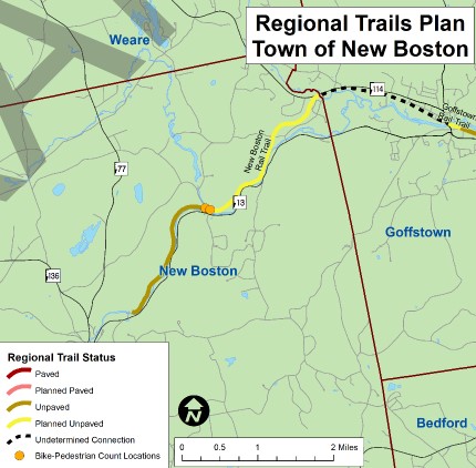
The Goffstown Rail Trail travels along the railroad bed of the old Goffstown & Manchester Railroad, also known as the NH Central RR and later the North Ware Branch of the Concord RR. Starting from the Western End of the Piscataquog Trail in Manchester, the trail travels West through Goffstown. Future plans call for continuing the West, to the New Boston Rail Trail in New Boston. For more information visit; GOFFSTOWN RAIL TRAIL .
Starting from the Goffstown/Manchester Town Line [Eastern End]; The 0 Mile Marker is painted on a short white post next to the trail. Mile Markers are located every 0.5 miles along the trail.
Note; Heading East, the paved Piscataquog Trail crosses over the Piscataquog River Reservoir and continues into Manchester. See; Manchester Trails .
Heading West, the wide, crushed gravel Goffstown Rail Trail travels along a high berm with the Piscataquog River Reservoir below. You'll quickly pass by a fence on your left with a gap that takes you up to the Sarette Recreational Complex parking lot. Continuing along the shaded ridge-line the trail then travels along a short berm before passing by the Moose Club Park Road parking lot at 0.6 miles. A Map Board is located here. The trail continues along the ridge-line before passing by an old cement RR Whistle Post on your right and crossing Lynchville Park Rd at 1.3 miles. + See; RR Whistle Post Below. The stone-dust trail passes through a rock cut heading inland where you'll cross Morgan Circle followed by Danis Park Road parking lot at 1.7 miles. Pass by an old cemetery on your right followed by a Map Board before coming alongside the NH Prison for Women. A cross-light takes you over Henry Bridge Rd at 2.4 miles. Continue straight out to Mast Rd at 2.7 miles where an automated cross-light takes you across this busy road. As you travel West nice stone pavers serve as the trail until you pass in front of Pro Landscape. The stone-dust trail then runs behind Magoo's Drive-In. It parallels Mast Rd. At 3 miles a short section of trail consists of hard packed dirt and gravel, as of March 2024. Also, as you approach the Shell Gas Station at 3.5 miles, another short section of trail consists of hard packed dirt and gravel, as of March 2024. The trail then travels left, around this gas station out to Tatro Dr. The now paved trail takes you across Tatro Dr and back to Mast Rd. The wide, hard packed gravel trail continues West, through the woods and out to Mast Rd. Another automated cross-light gets you over the road to a crushed gravel trail that passes by the Mast Road parking lot at 4 miles. Kiosk and Map here. Pass by Glen Lake along your right before crossing a small bridge. Pass by the Goffstown Parks & Rec. parking lot next to Mast Rd at 4.5 miles. Map Board located here. Cross Shirley Park Rd where the trail consists of crushed gravel to E Union St. Pass by another old cement RR Whistle Post on your right before crossing Shirley Park Rd again where your afforded views of Glen Lake. Come to East Union St at 5 miles. Here you'll turn right and follow a Separated BIKE LANE alongside Union St to a sharp left at 5.3 miles where you pick up the rail trail on your right. Cross *Factory Street and you'll come to an old RR bridge abutment, overlooking the Piscataquog River at 5.5 miles and the end of the trail. Rotary Park is located across the river and the Route 114 bridge is on your left. A dam is on your right.
Note; To connect to the New Boston Rail Trail in New Boston, which utilizes the same old rail bed as the Goffstown Rail Trail.
Note; According to the website, I believe there is a BIKE LANE all along this route now.
From *Factory Street, you can head Southwest, up to Route 13 and turn right, North, on-road (wide sidewalk available) across the river you'll pass by Rotary Park on your right, where a brick walkway leads to an overlook of the Piscataquog River. Come to Mill & Depot Streets. Turn left, West, along Depot St (old rail bed) and you'll pass by the old Goffstown Village RR Depot on your right. Beautifully re-purposed.
Note; Most of the old rail bed is inaccessible West, to the New Boston Rail Trail in New Boston.
Continue on-road, along Depot St (low traffic), then turn right up Kendall-Hadley Row to Church St and head left, on-road (narrow paved trail available/ residential). Come to Mast St (Route 14) after 0.8 miles. Continue left, West, on-road (wide shoulder/high traffic/narrow paved trail parallels this road). Come to Parker Station Rd at 1.7 miles and continue along N Mast S (wide shoulder/high traffic) a short distance to Parker Rd at 2 miles, across the road. Caution; No crosswalk/high speed traffic. Travel South, down Parker Rd to Riverside Dr and turn right. At the sharp curve, straight will bring you to the Riverside Drive parking lot in New Boston, after 2.2 miles. This is the start of the New Boston Rail Trail .
Old Railroad Equipment:
+
RR Whistle Post:
The Whistle Post,
was a post with a large "W" engraved or painted on it. This
meant the railroad engineers were to start sounding the trains Whistle.
The Whistle posts
were usually placed 0.25 miles
in advance of a road crossing,
bridges, tunnels and other points. Usually, there would be a post placed on both
sides of the crossing, covering both directions.
HH
CLICK HERE FOR GOFFSTOWN RAIL TRAIL MAP
CLICK HERE FOR MANCHESTER-GOFFSTOWN MAP
BEFORE YOU SET OUT BE SURE TO READ THE
WAIVER OF RESPONSIBILITY AND DISCLAIMER
BIKE IT OR HIKE IT