UPPER CHARLES TRAIL:
MILFORD-HOLLISTON-ASHLAND-HOPKINTON, MASSACHUSETTS
-BIKE IT OR HIKE IT-
Letterbox Planted: July 29, 2006
Last Updated; April 22, 2026
Length: Upper Charles Trail; Hopkinton section;
Center Trail; 1.2 miles
Campus Trail Connector; Future
Echo Rail Trail; 0.6 miles
Upper Charles Trail; Milford section; 6.4 miles
Senior Center Spur; 0.4 miles
Clark Island Loop Trail; 0.5 miles
Upper Charles Trail; Holliston section; 6.8 miles
Upper Charles Trail; Sherborn section; 0.3 miles
Upper Charles Trail; Ashland section;
Stone Park & Trolley Brook Trails; 0.8 miles
Memorial Drive Path; 1 mile
Difficulty: Upper Charles Trail; Hopkinton section;
Center Trail; Easy. Crushed gravel rail trail.
Echo Rail Trail; Wide stone-dust rail trail.
Upper Charles Trail; Milford section; Easy. Mostly flat, paved rail trail.
Upper Charles Trail; Holliston section; Easy. Flat stone-dust rail trail.
Upper Charles Trail; Sherborn section; Easy. Flat stone-dust rail trail.
Upper Charles Trail; Ashland section;
Stone Park & Trolley Brook Trails; Easy. Flat, paved trail.
Memorial Drive Path; Easy. Slight grade. Wide paved trail alongside road.
Directions:
To start from the Claflin Pl parking lot in Hopkinton [Eastern Side; Northern End]; Take exit 54A off of I-495 to Main St heading east. Turn right on Claflin Pl after 1.1 miles where you'll find a parking lot on your left.
To start from the Route 85 parking lot in Milford [Eastern Side; Northern End]; Take exit 50 off of I-495 and travel north up Route 85 about 1.5 miles. Just before you reach the Hopkinton town line, the parking lot will be on your right.
To start from the Veterans Memorial Drive parking lot in Milford [Western Side; Southern End]; From I-495 take exit 48 to Route 109 west. Less then a mile turn left on Veterans Memorial Dr. On your right is the parking lot.
To start from the Railroad Street parking lot in Holliston [Western Side; Central Section]; Take exit 48 off of I-495 to Route 109 and head west. Immediately turn right on Beaver St, then right on Route 16 (Route 16 becomes Route 126 and continues north). Travel 4.7 miles before turning right on Central Ave. Just past Railroad St on your left will be a parking lot. The trail travels through this lot.
To start from the Whitney Street parking lot in Holliston/Sherborn [Western Side; Northern End]; From the Junction of Routes 16 & 27 in Sherborn, travel south on Route 16 to Maple St and head west to Western Ave. Turn right, then a quick left on Whitney St and after 0.5 miles parking lot is on your left.
To start from the Summer Street parking lot in Ashland [Northern Side; Northern End] From the junction of I-90 & Route 9 in Framingham, follow Route 9 east and take your first right on Country Club Rd. Bare left along Gates St and follow to Salem End Rd. Continue south along Badger Rd, which becomes Myrtle St, then Main St. Cross the RR tracks and take your first right on Summer St. Parking lot next to the playground.
The Upper Charles Trail is a planned multi-use trail along an abandoned rail bed. It will travel through the towns of Milford, Hopkinton, Ashland, Sherborn and Holliston, creating a Loop. The trail is currently shaped like a horseshoe, with Hopkinton & Milford comprising the Western Side and Milford, Holliston & Sherborn the Eastern Side. Hopkinton & Ashland comprise the open Northern Side. As of 2025; the trail is complete in both Milford and Holliston. In Hopkinton, the Center Trail and Echo Trail have been completed. In Sherborn the trail just crosses the Holliston border and quickly ends. In Ashland, the Trolley Brook Trail & Memorial Drive Path are complete and connected. The Hopkinton & Milford RR was constructed in 1871/72 to connect the Boston & Albany RR in Ashland to the Milford & Woonsocket RR in Milford. A total of four rail lines used to serve Milford. In 1898, the NY-New Haven & Hartford RR acquired this line, which was abandoned in1959. For more information visit; MILFORD; UPPER CHARLES TRAIL & HOPKINTON; UPPER CHARLES TRAIL , FRIENDS OF HOLLISTON TRAILS , ASHLAND; UPPER CHARLES TRAIL .
Upper Charles Trail; Hopkinton Section:
Center Trail:
Starting from the Claflin Pl parking lot in Hopkinton [Northern End]; The trailhead begins off Main St. You'll find a Map Board here.
Note; Heading left, Southwest, down Main St (sidewalk available). After 0.3 miles, past Whalen Rd, the sidewalk becomes a paved trail and levels out. After 0.5 miles, spot the old Hopkinton RR Depot (1872), across the road, next to Ice House Pond. Pass by an entrance for the Berry Acres Conservation Area before the trail reverts to narrow sidewalk at 0.7 miles. Picnic tables located by the pond and RR Station.
Note; Heading right, Northeast, a double wide sidewalk takes you through downtown Hopkinton to the Hopkinton Town Common after 0.6 miles.
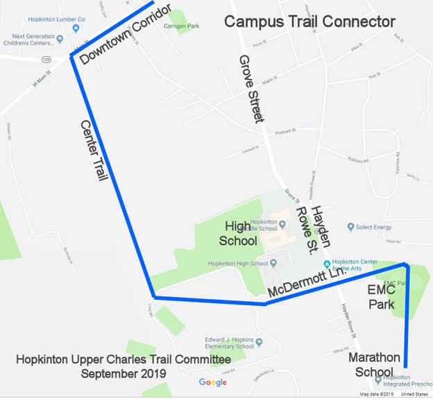
The Upper Charles Trail; Center Trail heads South, from Main St along the old rail bed. This wooded corridor consists of a crushed gravel surface. A high berm soon leads to several informational signs about the old RR. The first sign points to an old wooden RR Whistle Post on your left. + See; RR Whistle Post Below. You cross a couple of wooden bridges before the trail leaves the old rail bed and heads slightly uphill. You come to Loop Rd at 0.6 miles.
Note; The narrow, paved Loop Road Path follows alongside Loop Rd and travels past the Hopkinton High School & Edward J. Hopkins Elementary School forming a 1 mile Loop.
Note; The future Campus Trail Connector, will follow the old rail bed East, through the woods, crossing Loop Rd again. It will then continue through the woods out to and across Hayden Rowe St, where it will connect to EMC Park. See Below.
Head right, South, along the narrow, paved Loop Road Path, crossing a wooden bridge, before coming to Lot X/Fields 12 & 13 at 0.9 miles. Bear right through the parking lot, where the crushed gravel trail takes you left, past the ball fields and back into the woods. Yellow circles mark the route. The trail currently ends after 1.2 miles at Chamberlain St.
Note; A Gap exists South, to the Echo Trail.
Echo Trail:
Starting from Granite Street in Hopkinton [Northern End]; I haven't checked out this trail yet. The wide, stone-dust Echo Trail travels South, through the woods along the old rail bed. I believe it is 0.6 miles long.
Upper Charles Trail; Milford Section:
Starting from the Route 85 parking lot in Milford [Northern End]; Map Board here.
Note; Future plans call for continuing the trail North, through Hopkinton. The old rail bed continues on the Western Side of Route 85 and crosses into Hopkinton almost immediately. This section will connect to the Echo Trail. See; Hopkinton Section Above.
The paved Upper Charles Trail heads South, through the woods and there appears to be a second rail bed or old road on your left, paralleling this trail? When you come to a wide grassy area on the right with four boulders at the edges, just past a black access gate, this is where an old rail siding began. It runs past the two large boulders on the left and parallels the trail. At 0.5 miles you'll see a row of granite piers that used to support the elevated RR siding, which was built in 1897 and used to provide access to a nearby quarry. Just before Route 85 spot an old cement RR Whistle Post. + See; RR Whistle Post Below. After a mile an automatic cross-light takes you over Route 85 where you'll cross a small bridge over the Upper Charles River, travel past Wildcat Pond and return alongside Route 85 at 1.5 miles. Use Caution when crossing in front of the I-495 on-ramp, as well as, the off-ramp after you travel underneath the highway. The trail then heads down away from Route 85 and comes to an intersection.
Note; Left, South, follows an old road bed to Old Cedar St, which will bring you back out to Route 85. Places to eat and restock are located here.
Continuing West, after a hairpin turn, the trail heads up a slight incline. Just before a large stone abutment on the right and a granite bench on the left will be a dirt road at 2 miles. From the trail, take 32 paces (2 steps = 1 pace) down the road, just past a moss covered boulder poking into the road and next to a dead tree and stump off the right side of the road. Look to the left side of road and spot a stone wall between the gap of large trees. Go to the tallest section in stone wall (there should be a marble or quartz type rock on the very top). Go to the backside of the wall and remove only one flat rock that is leaning against the wall. Behind this rock is the Upper Charles Trail Letterbox. The trail winds through open woods, which are full of rocks and boulders and past granite and stone benches. A 2.6 miles you pass by a Spur Trail that leads to apartments off of Shadowbrook Lane. The trail then travels South, alongside Louisa Lake before coming to Louisa Lake Park. Check out the black "bike" gate leading to the parking lot. A Map Board, picnic tables and dam with spillway are located here. An automatic cross-light takes you over Dilla St at 3.1 miles. Check out the bike sculpture on your right as you travel through an industrial corridor along your right and Milford Pond along your left. At 3.4 miles you pass by another spur trail on your left.
Note; You can take a short side trip here along the Clark Island Loop Trail. Head left, East, along the wide dirt road as it travels alongside Milford Pond before ending at the tip of the island at 0.2 miles. To return head right along the grassy area to a hard packed dirt trail that follows along the opposite side of the island and back to the trail after a 0.5 mile Loop.
Continue past Cedar Swamp Pond to your left, followed by Fino Field before coming to an *Intersection at 3.8 miles. Turn left to continue along the Upper Charles Trail. No signs.
Note; From this *Intersection continue straight, South, along the Senior Center Spur which takes you past Hayward Field and out to Main St (Dunkin Donuts located here) and another automatic cross-light. The trail ends at the Milford Senior Center after 0.4 miles. If you continue South, through the parking lot you'll come to Central St. You can see the original RR tracks on the opposite side of the street. Head left and you'll come to the old stone Milford RR Station. Head inside and check out the beautiful wooden walls.
From this *Intersection head left, East and follow the trail past Fino Pool on your left and you'll come to another intersection.
Note; Straight takes you over a spillway for Cedar Swamp Pond and the Upper Charles River and out to Meade St.
Bear right, South and follow the trail past Hayward Field and you'll come to the Milford commuter parking lot at 4.1 miles. Map Board located here. Continue straight through the parking lot out to Main St.
Note; If you go to the East Side of the parking lot, you'll see where the Upper Charles River is diverted underground through town.
There are two cross-lights over Main St. Use either one and continue straight down Beach St (side walk available). Take a quick left on Mt Pleasant St, where you'll pick up the paved trail again on your left at 4.3 miles. The trail now travels Northeast, along a residential corridor crossing Hayward St and coming to Veterans Memorial Dr after 4.9 miles. The trail follows this road out to Route 109.
Note; Just before Route 109 on your left is the Veterans Memorial Drive parking lot.
An automatic cross-light takes you Northeast, across Route 109 to another a Map Board at 5.1 miles. Here the trail travels along the transmission line corridor. You pass the Route 16/Prezo Bar & Grill parking lot at 5.5 miles. Another automatic cross-light over Beaver St and then you travel underneath I-495. Next you'll pass through a large marsh and travel underneath two crossing sets of transmission lines. Enter the woods and travel along a berm before coming to the end of the paved Milford Section at 6.4 miles. Zain Circle is on your left. You now enter the Holliston Section.
Upper Charles Trail; Holliston Section:
Continuing from the end of the Milford Section; [Continuing Mileage] The Upper Charles Trail; Holliston Section has a stone-dust surface and travels Northeast, through the woods before emerging at South St at 6.8 miles. There are informational signs and some exercise stations located along the Holliston section. Turn left along the sidewalk, then right across the street where the stone-dust trail continues. A berm takes you alongside scenic Hopping Brook Marsh, crosses over Beaver Brook, then out to Hopping Brook Rd at 7.5 miles. You'll pass by a solar farm along your left followed by a high berm past scenic Hopping Brook Marsh and across an wooden bridge over Hopping Brook at 7.9 miles. Cross Chestnut St at 8.5 mile sand a small culvert next to a pond at 8.7 miles. Just before this culvert on your right is an old RR semaphore (railway signal of some type) followed by an old cement RR Whistle Post just past the culvert. + See; RR Whistle Post Below.
Note; Left a Spur Trail leads to ice cream!
You pass by a second old RR Whistle Post on your left, before a cross-light over Summer St at 9.2 miles. The trail travels alongside then over Chicken Brook where you'll pass by a Map Board for both the Upper Charles Trail, as well as, the Wenakeening Woods Conservation Area.
Note; Story Book Walk informational signs start from Cross St.
Just before Cross St, at 9.3 miles, look left to spot another old cement RR Whistle Post. Map Board and BIKE STATION, as well as, an Exercise Station. The trail then takes you through the beautiful stone arched Phipps Tunnel under Highland St at 9.7 miles. Brick lined ceiling and sides. This is a trail highlight. The trail now travels through a low cut with large cut stones lining the sides. Pass by two benches overlooking a horse farm on your left. Cross an old RR bridge over Arch St followed by a second over Exchange St. Hit Central St in the Mudville neighborhood of Holliston. A Map Board and gazebo are located here. Parking located along your right, as well as, across the street next to the old Mudville Depot. Use Caution, a crosswalk but this is a busy street. The trail follows the road past the old RR Depot to Church St at 10.7 miles. The stone-dust trail continues parallel to Woodland St before approaching the 8 Arch Stone Bogastow Brook Viaduct at 11.2 miles. Eight stone arches support the bridge as it crosses Bogastow Brook. Continuing straight across the bridge, you'll pass by an old granite RR Mileage Marker reading B26 (Boston 26 miles?). These old RR Mileage Markers were located every mile along the railroad. Cross Lowland St at 11.5 miles, where the stone-dust trail continues. Pass by a cement RR Whistle Post, before crossing Washington St at 11.9 miles. The trail continues North, along a straight long wooded corridor, crossing Mayflower Landing, before heading through the Dopping Brook Marsh. Cross the Sherborn town line after 13.2 miles where the Dopping Brook crosses. I haven't checked out this new section. The stone-dust trail continues North, to the Whitney Street parking area at 13.5 miles.
Note; The old rail bed continues North, through Sherborn, where RR tracks are still in place as it enters a RR Yard. No info about plans to extend this section, as of 2025.
Upper Charles Trail; Ashland Section:
Stone Park Trail-Trolley Brook Trail-Memorial Drive Path:
Starting from the Summer Street parking lot in Ashland for the Stone Park Trail [Southern End]; I haven't checked out these trails yet. The paved Stone Park Trail travels North, past Stone Park to Park Rd at 0.2 miles. Head left, on-road (low traffic) to Cherry St and continue right. Quick left on Megunko Rd and you'll come to the Upper Charles Trail; Trolley Brook Trail [Northern End] on your left, just shy of 0.4 miles. Map Board. The paved Upper Charles Trail; Trolley Brook Trail travels South, through the woods along an old rail bed. Pass by a pond on your left. Cross a bridge over a creek, before coming to Memorial Dr after 0.8 miles. Here, you'll pick up the Memorial Drive Path. The wide, paved Upper Charles Trail; Memorial Drive Path intersects here. Map Board & cross-light.
Heading East, left, the trail travels alongside the road, with woods along both sides, up a slight hill. Come to Route 135 after 0.2 miles.
Heading Northwest, right, the trail travels alongside the road, with a slight uphill grade. Pass by Walker Field (parking) where woods line both sides of the road. Come to the Ashland MBTA Station after 0.8 miles [1.6 miles Total].
Old Railroad Equipment:
+
RR Whistle Post:
The Whistle Post,
was a post with a large "W" engraved or painted on it. This
meant the railroad engineers were to start sounding the trains Whistle.
The Whistle posts
were usually placed 0.25 miles
in advance of a road crossing,
bridges, tunnels and other points. Usually, there would be a post placed on both
sides of the crossing, covering both directions.
HH
CLICK HERE FOR UPPER CHARLES TRAIL MAP
CLICK HERE FOR ASHLAND SECTION TRAILS MAP
CLICK HERE FOR ECHO RAIL TRAIL MAP
LETTERBOX LAST VERIFIED ON
NOVEMBER 18, 2016
TO EMAIL A VERIFICATION
bikeitorhikeitcontact@gmail.com
BEFORE YOU SET OUT BE SURE TO READ THE
WAIVER OF RESPONSIBILITY AND DISCLAIMER
BIKE IT OR HIKE IT