UNCLE SAM BIKEWAY:
SOUTH TROY RIVERFRONT BIKEWAY:
TROY, NEW YORK
-BIKE IT OR HIKE IT-
Last Updated: August 22, 2025
Length:
Uncle
Difficulty:
Uncle
Directions:
To start from the Waterford Harbor Visitor Center in Waterford; Take I-787 north to Route 787 north to Route 32 (Saratoga Ave) across the Mohawk River into downtown Waterford. Turn right down 2nd St which will bring you to the parking lot on your right just before the bridge.
To start from the Northern Drive parking area for the Uncle Sam Bikeway in Troy [Northern End]; From the junction of Routes 4 & 32 in downtown Waterford head east on Route 4 and cross over the Hudson River. Bear right on Route 4 (2nd Ave) at the light. At your next light turn left up Route 142 (125th St). At the five-way intersection, cross over to Northern Drive and follow it up a small hill. The bike trail starts across from Old Mill Hill Rd on the right. A gravel road on the right leads up to a small grass parking area.
The Uncle Sam Bikeway
runs along the
former rail bed of the Troy & Boston Railroad which was constructed
in 1850-52. This in turn became the Fitchburg Railroad in 1887 and then
the Maine Railroad in 1900. The tracks were dismantled in 1972. Samuel
Wilson was the Troy
meatpacker and Massachusetts
native who many believe was the inspiration for the Uncle Sam figure.
Supporters of the Wilson
story say he became associated with Uncle Sam when he stamped the initials
"US" on barrels of meat he supplied to American forces in the war of 1812.
Seeing the initials, soldiers began referring to Wilson
as Uncle Sam. Samuel Wilson died in 1854 and is buried in Troy
's
Oakwood
Cemetery, which is located on the hillside above the trail. The Uncle Sam Bikeway
travels from Northern Dr, South,
through Troy, along the former rail bed. You can then continue South,
along the South Troy Riverfront Bikeway, which is comprised of both paved
trails along the Hudson River and BIKE LANES. From the Northern
End of the Uncle Sam Bikeway, you can
travel West, on-road,
across the Hudson River to the Waterford Harbor Visitor
Center.
Here you can
access two other trails from the Waterford
Harbor Visitor
Center. See; Champlain Canalway Trail;
Waterford-Mechanicville and Black
Bridge Trail . For more information visit; TROY
URBAN TRAILS .
Waterford Harbor Visitor Center:
Starting from the Waterford Harbor Visitor Center parking lot; A small museum is located in the upper section of the Visitor Center, by the parking lot. A brick path from the parking lot will take you down to the Canal Walkway, which travels alongside both the Mohawk River & Erie Canal. Map Board & restrooms located here.
Note; Heading Northwest, along the Canal Walkway, alongside the Erie Canal, will take you to an intersection just below the South St bridge. Right, a brick & cement path will take you up and over the South St bridge, along the Southern End of the Champlain Canalway Trail; Waterford-Mechanicville . Continuing North, underneath the South St bridge, will take along the Champlain Canalway Trail; Waterford-Mechanicville .
Note; Heading Southeast, along the Canal Walkway, alongside the Mohawk River, will take you underneath the 2nd St bridge to a spur trail on your left. This trail will take you up to 2nd St, where a pedestrian bridge will take you South across the Erie Canal to Pebbles Island and the Black Bridge Trail .
To connect to the Uncle Sam Bikeway in Troy; Travel Southeast, along the Canal Walkway, alongside the Mohawk River, underneath the 2nd Street bridge and out to Battery Point and the Waterford Boat Launch parking lot. After checking out where the Mohawk River and Erie Canal flows into the Hudson River, head back through the parking lot to 1st St. Follow 1st St North, on-road (residential), out to Broad St (Route 4).
Note; You can take a quick detour to check out the old Waterford Train Station. Just cross over Broad St and continue North up 1st St. Take a left on Division St and then a right on 2nd St. This will bring you to Columbia St after 0.3 miles. The old combination Waterford Station and D & H Freight Office now houses the Waterford Public Library. This station, built in 1896, was part of the 1835 Rensselaer-Saratoga Railroad Line, later a branch of the D & H Railroad.
Turn right, East, following a sidewalk along Broad St and across the Hudson River to Troy. Continue straight across 2nd Ave (Route 4) and on-road along 126th St (residential). Follow this road as it turns South and narrows, bringing you to 125th St. Continue left, East, on-road (no shoulder or sidewalk) up a small hill. At the five-way intersection, bare left to Northern Dr (no shoulder) and follow it up a small hill to the start of the Uncle Sam Bikeway on your right after 1.2 miles.
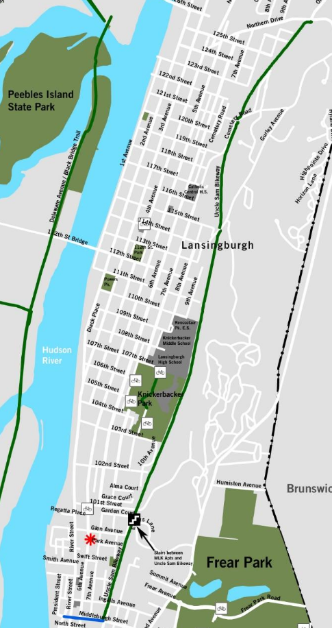
Uncle Sam Bikeway:
Starting from the Northern Drive parking lot in Troy [Northern End]; [Re-zeroing Mileage] The paved Uncle Sam Bikeway heads into the woods traveling South, along a ridgeline, with houses below to your right. Cross Cemetery Rd and then Gurley Road parking lot where the trail opens up for a bit. After heading back into the woods you'll come to Knickerbacker Park along the right side of the trail. A large pink obelisk monument is here with fields below. After passing through a corrugated tunnel, you enter a residential area. The trail ends at Middlebourgh St after 3 miles.
Note; You can extend your trip South, along the South Troy Riverfront Bikeway, which includes both paved trails along the Hudson River, BIKE LANES and some on-road sections.
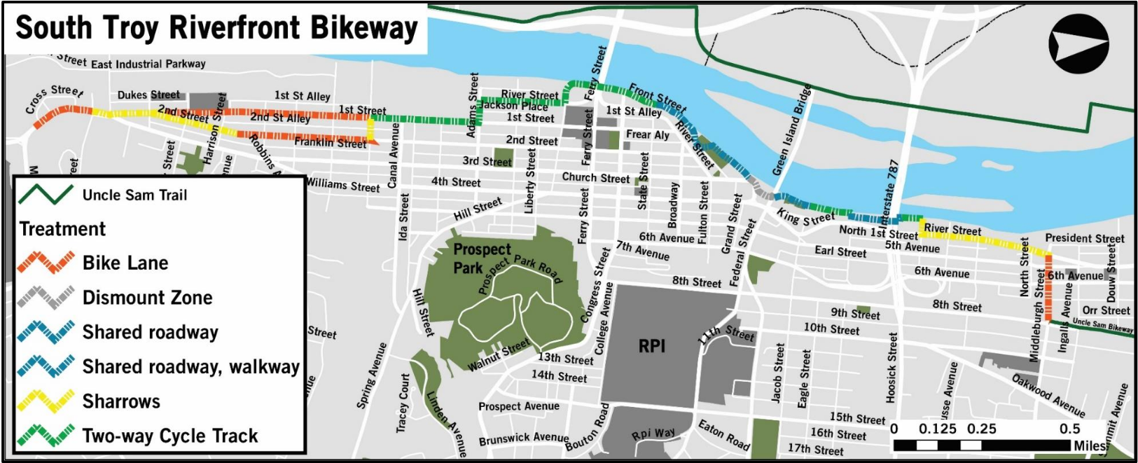
South Troy Riverfront Bikeway:
[Continuing Mileage] Head right, West, on-road, down Middlebourgh St to River St. Green Bike signs direct you along the South Troy Riverfront Bikeway.
Note; If you continue straight across River St and along Clyde Rea Pl, you quickly come to a parking lot. Here, a short section of the paved Troy Riverfront Trail travels North, along the Hudson River to the Ingalls Ave Boat Launch. Only 0.1 miles long.
Head left, South, on-road, along River St. Turn right after 3.6 miles on Vanderheyden St (spot the BIKE SHARROWS). Follow down to a parking lot next to the Hudson River. Head left, South, through the parking lot and travel underneath the Collar City Bridge (Route 7), past a gate and through another parking lot to Hutton St. This brings you to the off-road, cement, South Troy Riverfront Bikeway after 3.9 miles. The trail travels South, alongside the Hudson River. You travel underneath the Green Island Bridge (Lift bridge) and come to William Chamberlain Riverfront Park at 4.2 miles. Splash Park, amphitheatre, Korean War Memorial. Travel through the park, where a narrow trail continues, bringing you to a parking lot next to an old brick building. BIKE SHARROWS then bring you to State & Front Streets where you'll pick up a 2-Way CYCLE TRACK on your right at 4.6 miles. Continue South, along Front St, before turning inland to River St. Here the 2-Way CYCLE TRACK continues South, along River St, before turning left along Adams St, then right, South, along 1st St. Cross over Poesten Kill before coming to Madison St after 5.6 miles. This is the end of the CYCLE TRACK.
Note; If you travel right, West, on-road along Madison St, it will bring you to a promenade overlooking the Hudson River.
A One-Way BIKE LANE continues South, along 1st St. Just past Tyler St after 6.1 miles you'll follow BIKE SHARROWS (essentially "Share the Road" but with road markings). Come to the intersection of Polk St & 2nd St.
Note; If traveling North, use 2nd St. BIKE SHARROWS until just past Harrison St, where a BIKE LANE continues North, to Madison St. Head left back to 1st St and travel right along the 2-Way CYCLE TRACK back to State & Front Streets.
BIKE SHARROWS continue South, along 1st St to Burden Ave & Main St after 6.3 miles.
Note; If you travel right, West, on-road along Main St, cross the RR tracks and turn right on E Industrial Pkwy. The NPS BURDEN IRON WORKS MUSEUM parking lot will be on your right after 0.25 miles.
A BIKE LANE continues South, along Burden Ave (BIKE SHARROWS heading North). Come to High St after 6.6 miles, where the BIKE LANE ends.
Note; You can connect to the Mohawk Hudson Bikeway in Albany from here. Not recommended for novice bikers. Continue South, on-road (no shoulder/narrow sidewalk available) along High St to the Troy-Menands Bridge, where a pedestrian path on the bridge, takes you across the Hudson River to Albany. This path will take you directly to the Mohawk Hudson Bikeway after 0.8 miles.
HH
CLICK HERE FOR UNCLE SAM BIKEWAY MAP
CLICK HERE FOR SOUTH TROY RIVERFRONT BIKEWAY MAP
BEFORE YOU SET OUT BE SURE TO READ THE
WAIVER OF RESPONSIBILITY AND DISCLAIMER
BIKE IT OR HIKE IT