TROLLEY LINE TRAIL:
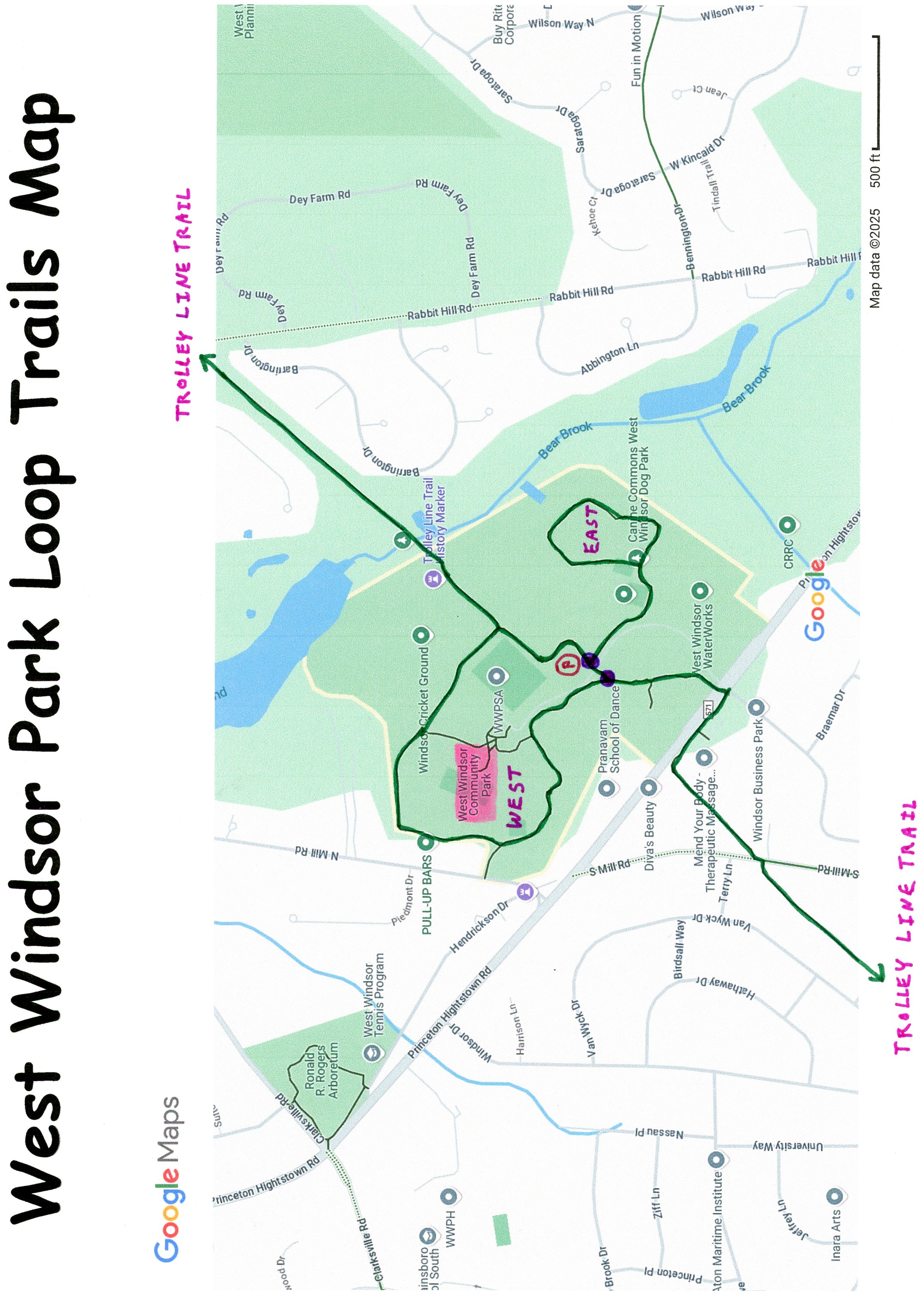
WEST WINDSOR COMMUNITY PARK LOOP TRAILS:
WEST WINDSOR, NEW JERSEY
-BIKE IT OR HIKE IT-
Last Updated: January 28, 2025
Length: Trolley Line Trail; 3 miles
West Windsor Park; West Loop; 1.1 miles
West Windsor Park; East Loop; 0.7 miles
Difficulty: Trolley Line Trail; Easy. Flat paved rail trail.
West Windsor Park; Easy. Flat paved trail.
Directions:
To Start from West Windsor Community Park [Northern Section]; From I-295 take exit 67 to Route 1 north. Take the first exit to Grovers Mill Rd. Cross Quakerbridge Rd and continue on Clarksville Rd for 4.6 miles. Turn right on Princeton-Hightstown Rd. The parks entrance will be on your left. Enter the park along Bernt Midland Blvd, pass by the large main parking lot on your right and take your next left to another parking lot. You can connect to all three trails from here.
The Trolley Line Trail travels North-South, following the rail bed of the former Fast Line Electric Trolley, that connected Trenton and New Brunswick through West Windsor. This is now a transmission line corridor. The trail passes through West Windsor Community Park, where you can access two Loop Trails through the park; West Windsor Park; West Loop and West Windsor Park; East Loop. There are no parking areas on either end of the Trolley Line Trail so you'll need to start from West Windsor Community Park.
Trolley Line Trail:
Starting from Village Road W for the Trolley Line Trail [Southern End]; The paved Trolley Line Trail travels Northeast, following an open transmission corridor. After 4 road crossings, cross S Mill Rd at 1.3 miles, where the trail veers into some woods alongside the power line. Come to Princeton Hightstown Rd and travel right, to a cross-light that takes you over to West Windsor Park. Briefly follow a sidewalk into the park, then head left along the paved trail. Travel through past ball fields and a playground to an *Intersection at 2.2 miles.
Note; Right will bring you to another **Intersection and the West Windsor Community Park parking lot on your left.
West Windsor Park; West Loop:
From the *Intersection, the paved West Windsor Park; West Loop travels straight, North, past a ball field to an intersection.
Note; Right, North, leads to parking lots, restrooms and a picnic pavilion.
Continue straight past the ball field, where the trail turns North, past the tennis courts and bear right at the next intersection. The trail then Loops around sports fields, turning Southeast, past more sports fields and you'll come to the Trolley Line Trail. Head right, South, passing by the West Windsor Community Park parking lot and you'll come to the **Intersection. Continue straight, back to the *Intersection, completing a 1.1 mile Loop.
West Windsor Park; East Loop:
Note; From the **Intersection, the paved West Windsor Park; East Loop travels East, past sports fields and the Skate Park before coming to a basketball court. Continue straight, past a Dog Park, where you enter some woods. The trail then travels North, into the woods, before Looping South, back past the basketball court, returning to the trail. Head right, West, back to the **Intersection, completing a Loop of 0.7 miles.
Trolley Line Trail:
Continuing from the **Intersection, travel straight, North, past the West Windsor Community Park parking lot, along the paved West Windsor Park; West Loop/Trolley Line Trail. The trail turns Northeast.
Note; The West Windsor Park; West Loop turns left.
The Trolley Line Trail continue straight along the power lines. Cross over Bear Brook via an old RR bridge, before coming to Rabbit Hill Rd after 3 miles.
HH
CLICK HERE FOR TROLLEY LINE TRAIL MAP
CLICK HERE FOR WEST WINDSOR PARK LOOP TRAILS MAP
BEFORE YOU SET OUT BE SURE TO READ THE
WAIVER OF RESPONSIBILITY AND DISCLAIMER
BIKE IT OR HIKE IT