SUDBURY AQUEDUCT TRAIL:
FRAMINGHAM-SHERBORN-NATICK-WELLESLEY-NEEDHAM-NEWTON, MASSACHUSETTS
-BIKE IT OR HIKE IT-
Last Updated: June 07, 2026
Length: Sudbury Aqueduct Trail; Framingham Northern Section; 1.4 miles
Sudbury Aqueduct Trail; Framingham Southeastern Section; 0.6 miles
Sudbury Aqueduct Trail; Natick Section; 1.3 miles
Sudbury Aqueduct Trail; Wellesley/Needham Section; 6.2 miles
Dudley Road Trail; 0.9 miles
Difficulty: Sudbury Aqueduct Trail; Moderate. Flat hard packed grass and dirt berm.
Dudley Road Trail; Easy. Wide paved trail.
Directions:
Starting from Winter Street parking lot in Framingham [Northern End]; From I-90 take exit 111 to Route 9 east. After 1.7 miles turn right along Winter St. Cross the Sudbury River and the parking lot is on your left, next to the brick building.
Starting from Memorial Elementary School in Natick [Eastern End]; From the intersection of Routes 27 & 135 in Natick head east on Route 135. After 0.4 miles turn right on Union St and travel 1.5 miles to Route 16 in S Natick. Head right and travel 0.5 miles to the school entrance on your right. Follow the entrance to an intersection and bear left past the tennis courts to a parking lot. Trailhead straight ahead.
The Aqueduct Trail System is an ongoing collaboration between the Mass Water Resources Authority and Metropolitan Area Planning Council. The focus is to identify and develop a connected trail system along the four Aqueducts (Cochituate, Sudbury, Wachusett, Weston). Starting from Berlin, the Wachusett Aqueduct Trail travels South, through Northborough, then East, to the Sudbury Reservoir in Southborough. The Weston Aqueduct Trail begins in Framingham and travels East, to the Weston Reservoir in Weston. The Sudbury Aqueduct Trail begins from the Sudbury River Reservoir in Framingham and travels East, to Newton. The Cochituate Aqueduct Trail starts from Natick and travels East, to Newton. For more information visit; AQUEDUCT TRAILS .
The Sudbury Aqueduct Trail follows the path of the Sudbury Aqueduct, which traveled 16 miles from Farm Pond in Framingham to Chestnut Hill Reservoir in Boston. The Aqueduct was constructed between 1875 and 1878, and was in use for almost 100 years. The main conduit from Farm Pond to Chestnut Hill Reservoir is inclined one foot per mile. At a number of places on the Aqueduct small buildings were built to house control equipment of various sorts, such as, Gate Houses, Metering Houses and Control Houses over Weirs where the Aqueduct crosses over other bodies of water. Parts of the Aqueduct are raised on an embankment, while others are in a cut, due to significant changes in local topography. Portions of the Aqueduct in Natick and Newton were created by tunneling, the longest being a 4,635-foot tunnel in Newton. In addition to the Echo Bridge, the Aqueduct also passes over the Waban Arches Bridge. The Sudbury Aqueduct Trail begins from the Sudbury River Reservoir in Framingham and travels East, through Sherborn, Natick, Wellesley, Needham, and Newton.
SUDBURY AQUEDUCT TRAIL:
Framingham East to Newton:
Framingham; Northern Section:
Starting from Winter Street parking lot [Northern End]; Map Board and informational sign. The grass w/single track Sudbury Aqueduct Trail travels South, from the Sudbury River Reservoir. The Sudbury River is briefly along your left before you travel through open woods along a residential corridor. Tree roots an issue. Come to Dudley Rd after about 0.6 miles. Head right along a narrow paved path to a crosswalk and cross over to the Dudley Road parking lot and Dudley Road Trail.
Note; The paved, 0.9 mile Dudley Road Trail travels North-South. I returned via this trail. See; Dudley Road Trail Below.
Continue straight through the parking lot and you'll come alongside Farm Pond, where the Aqueduct continues right, South, past the brick Aqueduct Gate House. You now travel between the pond and Farm Pond Park. Come to a *Causeway across the pond after 1.2 miles.
Note; You can follow the *Causeway Northeast, another 0.3 miles across the pond, to the large brick Aqueduct Gate House, but can't go any further and must back track.
From the *Causeway head right along a dirt trail which becomes a grass path through Farm Pond Park. Pass by a Skateboard Park on your right and continue straight. This will take you out to Fountain St & Dudley Rd at 1.4 miles.
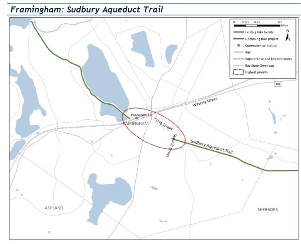
Note; A Gap exists, as of 2024, between the Framingham; Southeastern Section. See; Map Below.
Dudley Road Trail:
To return to the Winter Street parking lot, via the Dudley Road Trail; Head right to Dudley Rd, where the wide, paved Dudley Road Trail travels North, alongside the road. Farm Pond Park is along your right, Longs Athletic Field on your left. Pass by the Skate Park & parking lot, playground and another parking lot, before returning to the Winter Street parking lot & Sudbury Aqueduct Trail after 0.7 miles. The paved Dudley Road Trail continues North, before ending after 0.9 miles at Mt Wayte Ave. Here a BIKE LANE continues another 0.5 miles to Union St.
Sudbury Aqueduct Trail; Framingham Gap:

Framingham; Southeastern Section:
Starting from Summit Street in Framingham [Western End]; I haven't checked out this section. No parking available. The grass, Sudbury Aqueduct Trail travels East, through a residential corridor, crossing Irving St, along a partially open, industrial corridor. Pass by a brick Aqueduct Gate House, before crossing Leland St and coming to some RR tracks after 0.6 miles. Past the RR tracks the Aqueduct continues through Sherborn.
Sherborn Section:
I don't believe any sections of the trail are currently open to the public in Sherborn. From Sherborn, the Aqueduct enters a tunnel into Natick.
Natick Section:
Starting from Memorial Elementary School parking lot in Natick [Eastern End]; From the parking lot head straight past a signboard for the Eisenmenger Trail to an informational board for the Sudbury Aqueduct. The Sudbury Aqueduct Trail heads left, Southwest. Straight, North, is the Eisenmenger Trail which leads to Natick Center. Right, East, the trail dead ends.
Note; East, I believe the Sudbury Aqueduct enters a tunnel and so, is inaccessible.
The hard packed grass and dirt (occasional tree root) Sudbury Aqueduct Trail travels West, along the berm. Caution; Steep drop off both sides. After 0.3 miles you come to a brick Aqueduct Gate House. Continuing onward you'll notice granite culverts wherever water passes below. You'll also encounter square granite stones atop the berm every now and then. Most of these are surveyor's monuments marking the transition between straight segments and curved sections of the Aqueduct. Further investigation sometimes reveals a similar marker in the woods, which the surveyors used to determine the proper course, during construction of the Aqueduct. After 1.1 miles you come to another informational board at Cottage St. The trail continues across Cottage St, however, you soon get mucked down in water. The trail ends after 1.3 miles, where, I believe the Sudbury Aqueduct enters a tunnel and so is inaccessible. The tunnel then enters Sherborn. See; Sherborn Section Above.
Wellesley-Needham Section:
Starting from Echo Bridge, which crosses the Charles River between Newton & Needham [Eastern End];
Note; This section of the Sudbury Aqueduct Trail is also part of the Wellesley Trails .
The Sudbury Aqueduct Trail travels Southwest, along the paved bridge, to a set of stairs down to the dirt and grass trail along the Sudbury Aqueduct in Needham. The Sudbury Aqueduct Trail follows atop the Sudbury Aqueduct. After 0.3 miles you'll need to take an on-road detour to by-pass I-95. Head left down Reservoir St (residential), then right along Central Ave passing underneath I-95. Turn right up Saint Mary St and pick up the Aqueduct again on your left at 0.6 miles. Here, the trail travels Southwest, along a berm, out in the open, before crossing Cedar St and along the entrance to Eliot School. Bear right to pick up the trail again along the right and follow the Aqueduct through the woods to Hunnewell St at 1.6 miles. USE CAUTION as their is no cross-walk here. Continue along the wide grassy berm via a single-track dirt trail and you'll come to a brick Aqueduct Gate House structure. You can feel the cool air from the Aqueduct flowing through the bars in the windows. The trail heads downhill and comes to the intersection of the Southern End of the Charles River Path [Wellesley Trails] in Wellesley at 1.8 miles. After crossing Brookside Rd a short hill leads you up to another Aqueduct Gate House structure with marinates on top. The trail then comes alongside Wellesley Ave where you'll need to travel on-road (narrow shoulder) past the Wellesley Country Club. Just past the pool house on the right is an historical monument to the town and the Minuteman. When you reach the Forest St intersection, you'll need to turn left, then right into Babson College. Can be a bit tricky from here. A wooden post is located at ground level near the roads entrance with an arrow. Head up the road past Tomasso Hall (Babson College name above pillars) on your right and travel around the backside (look for arrows on light poles). Bear left along a paved path which weaves through the campus along Babson College Drive. You'll pass by the Olin School of Business before heading left along Bryant Way, then right Babson Way. The trail then heads left into the woods following a brook. Here the dirt trail is narrow and hilly before emerging at gas line in Needham. Parking lot across the gas line.
Note; You can check out Olin College by heading straight through the parking lot and then turning left into the courtyard surrounded by glass fronted buildings.
From the parking lot, turn right and follow the grassy path along the gas line to the bottom of the lot where the trail re-enters the woods. This dirt trail winds through the woods and comes to a T-intersection where it heads right. You come to another T-intersection and head right back along the Aqueduct. When you come to a berm the trail bears left alongside it before exiting out to Great Plain Ave.
Note; The Aqueduct continues along the other side of the road, however, the guardrail makes access difficult, so if biking it's easier to bypass.
To bypass, continue right along Great Plain Ave and quickly turn left, along the entrance road to the Recycling & Disposal facility You'll pick up the Aqueduct again on your right, where it crosses this road. Follow the wide, dirt & grass trail into the woods and soon you'll come to an Aqueduct Gatehouse at 4.3 miles. Fuller Brook travels underneath. Cross Wildon Rd and then a plank bridge where you'll head up a narrow dirt trail to Cartwright Rd. Next, cross over to Beebe Meadow at 4.9 miles and follow a paved trail past wildflower meadows. You'll come to a Map Board next to Benvenue St. Cross over and follow the trail left alongside the street. Cross Grove St for a short on-road section along this residential road. You'll come to Dover Rd at 5.5 miles. Head left up a short hill and return to the aqueduct on the right past a gate. The trail travels along a high berm (be sure to watch out for square granite T's along the center of the trail) past the Nehoiden Golf Course on your right. You cross the Waban Arch Bridge at 5.8 miles. Built in 1876, this 9 stone arch bridge crosses Fuller Brook, which feeds into the Charles River, which you can spot down to your left. Check out the old black iron railings marked BWW, which stands for Boston Water Works. Continue over the bridge and back along the trail before you come to a privately owned section. A dirt trail heads right, North and brings you to the Cheever House; Wellesley Center for Women parking lot at 6.2 miles. You then exit out to Washington St.
Note; West, the Aqueduct is broken up by private tracts, before it enters Natick. See; Natick Section Above.
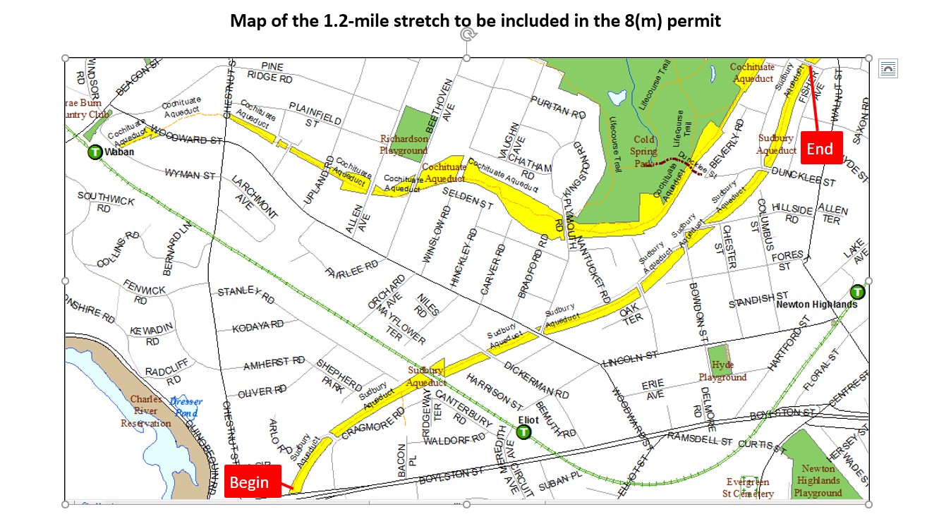
Newton Section:
Starting from Echo Bridge, which crosses the Charles River between Newton & Needham; The Sudbury Aqueduct Trail heads Northeast, along the paved bridge, to a set of stairs down to a narrow paved path.
Note; Stairs to your left lead down to Ellis St, where you can check out the stone arches of Echo Bridge, as well as, HEMLOCK GORGE RESERVATION. If biking, you can access Ellis St from Chestnut St by heading right on Chestnut St, then right down Ellis St.
Follow the narrow paved path out to Chestnut St in Newton.
Note; The Newton Section is very fragmented, with lots of on-road/off-road. I finally gave up halfway through after starting from Echo Bridge, as it wasn't worth it. Plans are underway to improve this section. See; WABAN COUNCIL along with the Newton Section Map Below.
A Gap exists Northeast, between Echo Bridge to Route 9.
On the Northern Side of Route 9, a short 0.3 mile section travels Northeast, before being blocked by RR tracks.
From the Northern Side of the RR tracks, the Sudbury Aqueduct Trail continues Northeast, crossing Dickerman St, as it travels through a residential corridor, with many street crossings and some blocked sections, that require a detour. Come to Bracebridge Rd after around 1.3 miles.
HH
CLICK HERE FOR AQUEDUCT TRAIL SYSTEM MAP
CLICK HERE FOR SUDBURY AQUEDUCT TRAIL; WELLESLEY SECTION MAP
CLICK HERE FOR THE SUDBURY AQUEDUCT TRAIL; NEWTON SECTION MAP
CLICK HERE FOR NATICK EISENMENGER TRAIL MAP
BEFORE YOU SET OUT BE SURE TO READ THE
WAIVER OF RESPONSIBILITY AND DISCLAIMER
BIKE IT OR HIKE IT