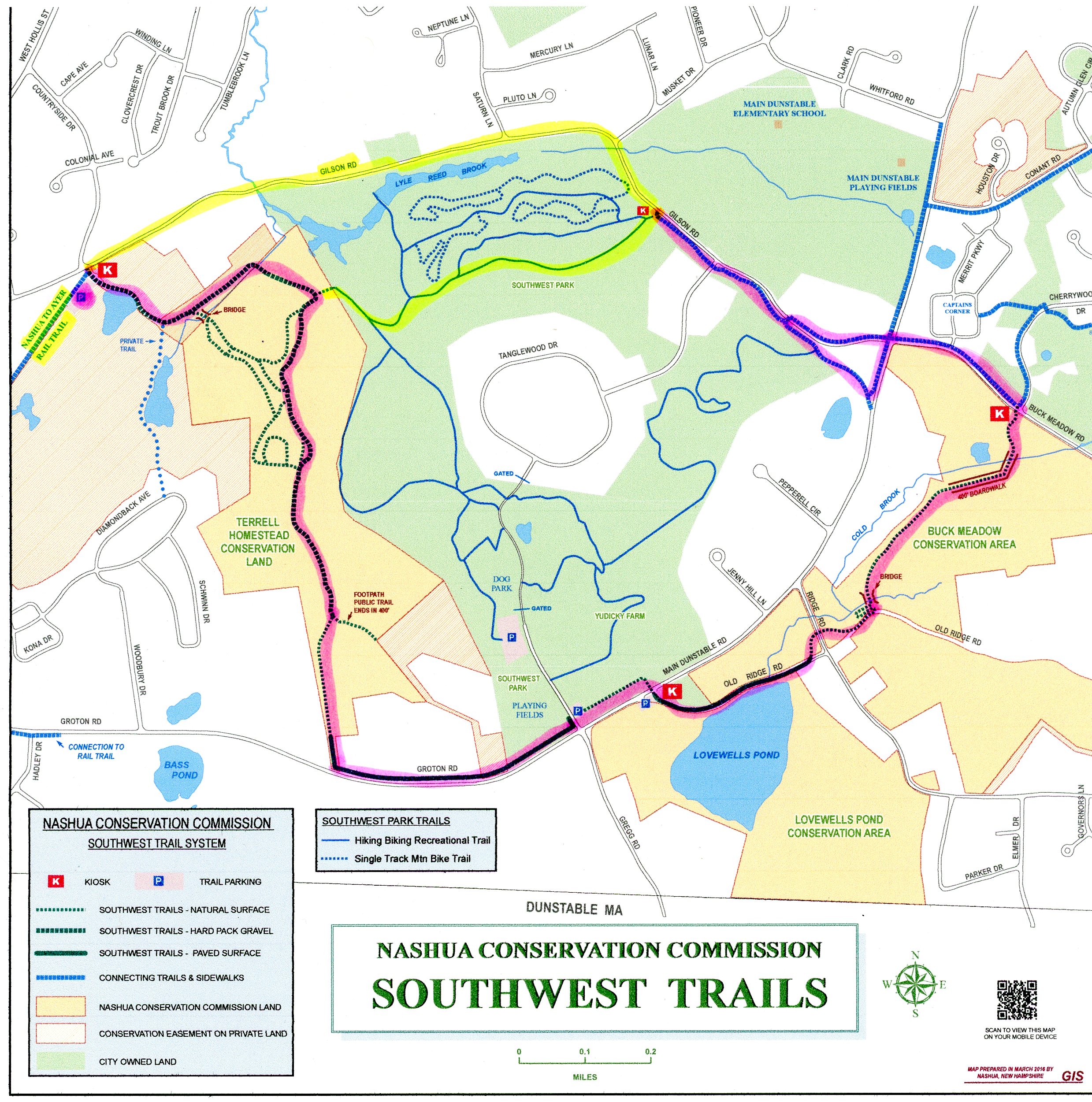
SOUTHWEST PARK TRAILS:
COLD BROOK NEIGHBORHOOD TRAIL:
NASHUA, NEW HAMPSHIRE
-BIKE IT OR HIKE IT-
Last Updated: August 17, 2025
Length: Southwest Trail; 4.3 mile Loop.
Cold Brook Neighborhood Trail; 3.2 mile Loop.
Difficulty: Southwest Trails; Moderate. Hard packed dirt, stone-dust and paved trails with some slight hills. On-road section.
Cold Brook Neighborhood Trail; Easy. Flat paved trail.
Directions:
Starting from the Gilson Road parking lot for the Nashua River Trail [Northern End] & Southwest Trail [Western End]; From Route 3 (Everett Turnpike) in Nashua take exit 5W to Route 111 west for 2.8 miles. Turn left on Country Side Drive, which will bring you to Gilson Rd. The parking lot is located straight ahead.
From the Northern End of the Nashua River Rail Trail [Gilson Road parking lot] you can connect to Southwest Park, which contains hiking and Mt biking trails, along with the Southwest Trail that Loops around the park. From the Eastern End of the Southwest Trail you may also access the scenic Cold Brook Neighborhood Trail. This trail travels East, through wildflower meadows and woods and is a great trail for kids. It the Loops West, Back to the Southwest Trail. Further North, in Nashua are two more trails. See; Nashua Heritage Rail Trail & Mine Falls Park Trails .
Southwest Trail:
Starting from the Gilson Road parking lot [Western End]; A Map Board is located next to the parking lot entrance.
Note; The paved Nashua River Rail Trail travels South, past the parking lot, crossing into MA after 1 mile.
Travel East, past the Map Board along the crushed gravel Southwest Trail past a gate and small pond before coming to an intersection. Head left, through the woods. Pass a wooden bridge on your right at 0.2 miles. Trail turns right and you soon come to an intersection.
Note; Left, Southeast, takes you to the Southwest Park; Yudicky Farm, where you can access Mt Bike Trails.
Head right, South, [Trails were not marked when I last rode trail (May be so now) so it can get confusing with all the intersecting trails, just keep along the wide gravel trail heading South] through the woods. Pass by some fields on your right followed by a sign for "Terrell Homestead Conservation Area" before emerging from the woods and connecting to a paved trail out to Groton Rd (Route 111A) at 1.1 miles. Follow the paved trail left, East, alongside the road and across the entrance to the Southwest Park; Yudicky Farm parking lot at 1.5 miles. Ball fields and a Dog Park located here. Continue straight, East, through the parking lot along a hard packed dirt trail. Turn right before the two boulders blocking the path to a cross-light over Route 111A to the Old Ridge Road parking lot at 1.7 miles. Map Board. Here the trail follows the old paved Ridge Rd East. Come to a scenic overlook of Lovewells Pond (Kettle Pond) where you find another informational sign. Head left, Northeast, when you come to a gate and a hard packed dirt & gravel trail will take you down and out to a cross-light over Ridge Rd at 2 miles. Continue along the hilly, hard packed dirt & gravel trail as you travel across an Esker. A switchback brings you down and across a bridge where the hilly trail winds through the woods before crossing a boardwalk at 2.4 miles across Cold Brook and Buck Meadow Conservation Area. Trail turns to stone-dust as you travel through a meadow, past a Map Board and across *Buckmeadow Road to a narrow paved trail at 2.6 miles.
Note; Straight, North, a narrow paved trail alongside Cherrywood Dr brings you to the Cold Brook Neighborhood Trail. You can ride this trail, which Loops back to *Buckmeadow Road, extending your trip. See; Cold Brook Neighborhood Trail Below.
Note; Right, across Cherrywood Dr, the narrow paved Buckmeadow Road Trail continues East, alongside Buckmeadow Dr before ending after 0.25 miles, just shy of DiAntonio Dr. Here a sidewalk leads to Brian S. McCarthy Middle School.
Follow the narrow paved Buckmeadow Road Trail left, West and you'll return to Route 111A (Main Dunstable Rd). Cross Route 111A and follow the narrow paved trail left, South, alongside Route 111A and you'll come to an intersection. Head right, Northwest, along the narrow, hilly, winding trail as it travels through the woods paralleling Gilson Rd. The trail ends after 3.3 miles next to Gilson Rd. Kiosk located here.
Note; You may attempt to Loop back to the Gilson Road parking lot from here by heading left, West, along the Southwest Park; Yudicky Farm Mt Bike Trails , however, I'm not sure how easy it would be to find the correct trail. Also the trail starts out sandy.
I chose to complete the Loop back to the Gibson Road parking lot via a 1 mile on-road detour. Head left, North, along Gilson Rd (low volume, but no shoulder and a hilly winding road: Not recommended for kids on bikes). Gilson Rd turns West and soon returns you to the Gibson Road parking lot after a 4.3 mile Loop.
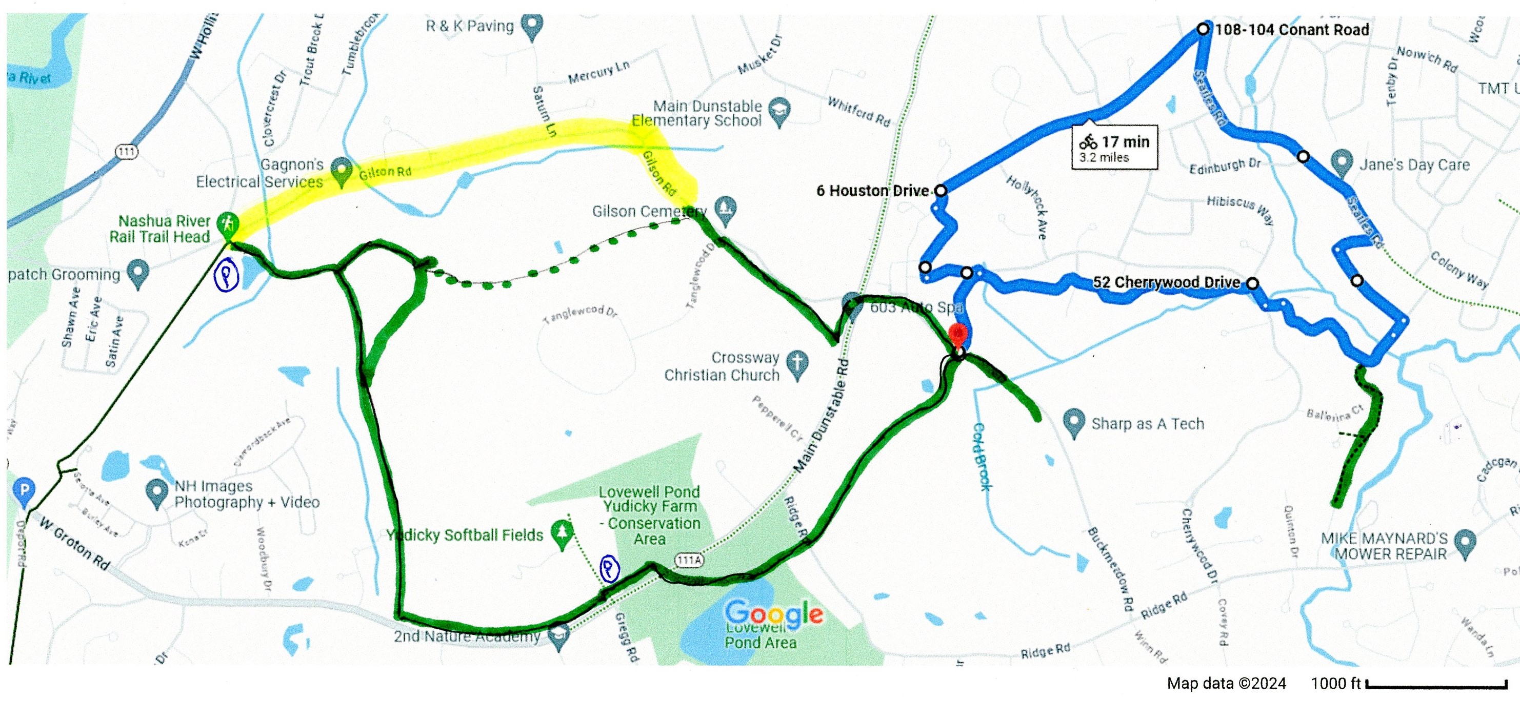
Cold Brook Neighborhood Trail:
Starting from *Buckmeadow Road and the Southwest Trail; Travel North, along the narrow, paved Cherrywood Drive Trail and come to an intersection.
Note; Left, West, the trail leads to Maplewood Plaza. This is where the trail will Loop back from.
Cross Cherrywood Dr and head East, into the open woods along the narrow, paved Cold Brook Neighborhood Trail. After one more street crossing you'll return to Cherrywood Dr. Turn right, South and cross over Cold Brook, then head left down a wide trail to a black fence. The trail continues right, South, along the fence past a small pond. After you travel through a Pine tree stand you'll encounter a gravel trail on your right.
Note; This gravel trail takes you 0.3 miles South to Curtis Dr.
Continuing left, North, along the paved trail that takes you over Cold Brook and out to Sheffield Rd at 1.2 miles. Continue straight, on-road, along Sheffield Rd (residential), then a quick left, Northwest, along Margate Rd (residential). Turn right on Millpond Dr, then left out to Searles Rd at 1.5 miles. Head left on-road (narrow shoulder) and travel to Conant Rd at 2.1 miles. Head left, Southwest, along the narrow, paved Conant Road Trail. Come to the Merrit Pkwy and the entrance to the Maplewood Commerce Center on your left at 2.7 miles. Enter Merrit Pkwy and take your first left on Mangerian Lane. Travel South, through the parking lot and follow the dirt road back to the paved Mangerian Lane. Head left through another parking lot, past which, on your left is the narrow, paved Cold Brook Neighborhood Trail. Travel East, through the wildflower meadow and you'll return to Cherrywood Dr. Return right, South, back along narrow, paved Cherrywood Drive Trail to *Buckmeadow Road and the Southwest Trail after a 3.2 mile Loop.
HH
CLICK HERE FOR SOUTHWEST TRAILS MAP
CLICK HERE FOR SOUTHWEST TRAILS LOOP MAP
CLICK HERE FOR SOUTHWEST TRAIL/COLD BROOK NEIGHBORHOOD TRAIL MAP
BEFORE YOU SET OUT BE SURE TO READ THE
WAIVER OF RESPONSIBILITY AND DISCLAIMER
BIKE IT OR HIKE IT