SARATOGA GREENBELT TRAIL:
SARATOGA SPA STATE PARK TRAILS:
SARATOGA SPRINGS, NEW YORK
-BIKE IT OR HIKE IT-
Last Updated: September 10, 2025
Length: Spring Run Trail; 1.1 miles.
Downtown Connector Trail; 2.5 miles.
Congress Park Outer Loop Trail; 0.7 miles
Railroad Run; 1.1 miles.
Geyser Road Trail; 2 miles
Saratoga Spa SP Inner Loop Trail; 4.5 mile Loop.
Saratoga Spa SP Outer Loop Trail; 6 mile Loop.
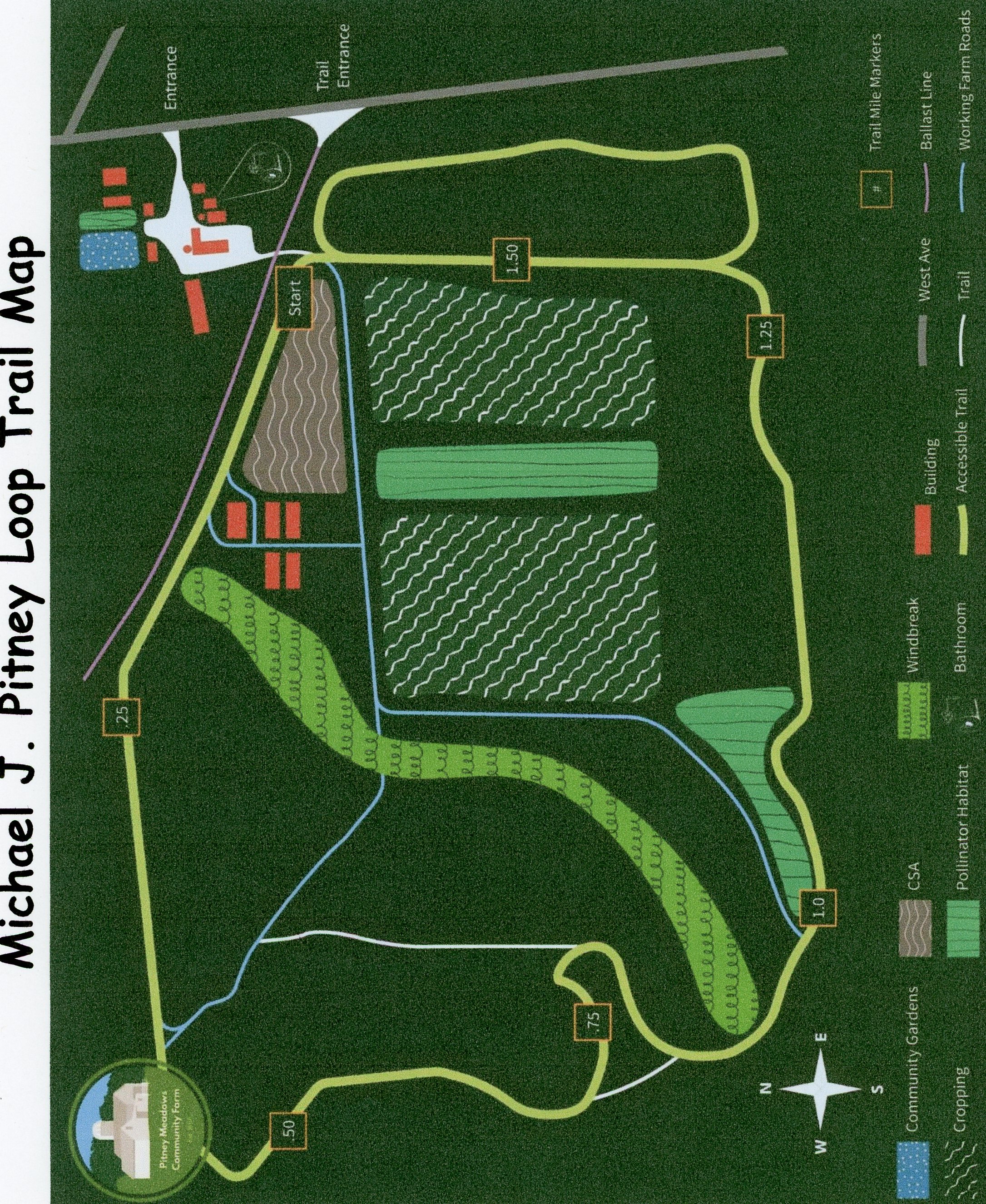
Michael J. Pitney Loop Trail; 1.7 mile Loop.
Difficulty: Spring Run Trail; Easy. Flat paved rail trail.
Downtown Connector Trail; Easy. Some on-road sections, paved trail & short 2-WAY BIKE LANE.
Congress Park Outer Loop Trail; Easy. paved trail, short hill.
Railroad Run; Easy. Flat paved rail trail.
Geyser Road Trail; Easy. Flat paved trail alongside Geyser Rd.
Saratoga Spa SP Loop Trails; Easy. Mostly flat paved, stone-dust and gravel trails. Some low traffic on-road sections. Couple of slight hills.
Michael J. Pitney Loop Trail; Easy. Flat, stone-dust trail.
Directions:
To Start from the Saratoga Automobile Museum parking lot/Saratoga Spa SP for the Saratoga Spa SP Loop Trails [Western End] & Geyser Road Trail [Eastern End]; From I-87 take exit 13N to Route 9 north and travel 2.9 miles. Turn left on Ave of the Pines. Come to an intersection and continue right. On your left is the entrance. Parking lots on your right and left. See; SARATOGA AUTOMOBILE MUSEUM .
To Start from the East Ave parking lot for the Spring Run Trail [Western End] & Downtown Connector Trail [Northern Section]; From I-87 take exit 15 to Routes 29 & 50 west. Just after Route 9 joins Routes 29 & 50 turn left on East Ave. Cross Excelsior Ave and come to the East Ave parking lot on your left.
To Start from the YMCA parking lot for the Railroad Run [Southern End]; From I-87 take exit 13N to Route 9 north. Pass by the park and turn left on W Fenton St. This brings you to Route 50. Cross over to New St and turn left on the YMCA entrance road. The trail runs from West Ave (other entrance) out alongside the road you just came in on.
The Saratoga Greenbelt Trail was envisioned to create a figure-eight Loop around and through the city, connecting together several existing & future trails. Starting from the Saratoga Automobile Museum parking lot/Saratoga Spa SP/Ave of the Pines; Heading West, you can access the Geyser Road Trail. Heading South, you follow the Saratoga Spa SP Loop Trail. Heading North, you follow the Saratoga Spa SP Loop Trail, which also connects to the Railroad Run, which travels North. From its Northern End, you can connect East, to the Downtown Connector, which travels Northeast, soon following alongside Route 50. It also connects to the Spring Run Trail, which travels East, along an old rail bed. The Bog Meadow Trail is also near by, but is a walking path. See; SARATOGA GREENBELT TRAIL & SARATOGA PLAN TRAILS .
The Railroad Run utilizes an old segment of the Rensselaer and Saratoga Railroad. In 1871, the D & H Railway, leased this RR and formally merged it in 1945. This old rail line also traveled South, where some sections of the old rail bed are utilized by the Saratoga Spa SP Loop Trails.
Saratoga Spa State Park Loop Trails:
Saratoga Spa State Park is listed as a National Historic Landmark and is noted for its diverse cultural, aesthetic and recreational resources. In addition to the nationally-known Saratoga Performing Arts Center ( SPAC ), the Spa Little Theater, the National Museum of Dance, the SARATOGA AUTOMOBILE MUSEUM , the Gideon Putnam Resort and Roosevelt Baths & Spa, the park offers a multitude of traditional recreation opportunities. There are many trails throughout the park. I've pieced together 2 Loop Trails that traverse the Park. The Outer Loop Trail encircles the park, while the Inner Loop Trail is a bit shorter but has more sights to see. For more information visit; SARATOGA SPA SP .
Starting from the Saratoga Automobile Museum parking lot/Saratoga Spa SP [Western End]; Exit the parking lot entrance out to Ave of the Pines; *Map Boards on both sides of the entrance.
Note; To access the Geyser Road Trail, follow the crosswalk over Ave of the Pines to a paved trail. Right, spot the stone spring water pavilion. Head left, West, along the Northern Side of the Ave of the Pines out to Route 50. Cross over to the start of the Geyser Road Trail after 0.2 miles. See; Geyser Road Trail Below.
Saratoga Spa SP Inner Loop Trail:
From the *Map Board: Head left, West, along the Southern Side of Ave of the Pines, along the paved Inner/Outer Loop Trail. Pass by the front of the Saratoga Automobile Museum, where the trail veers away from the road and around the back of the museum to the rear parking lot. Continue straight, South, away from the parking lot past a dam on Geyser Brook and into some woods. This brings you to a hard packed dirt rail trail. Turn right and travel between a fence on your left and a steep drop off to your right down to the brook. This is part of an old segment of the Rensselaer and Saratoga Railroad. In 1871, the D & H Railway, leased this RR and formally merged it in 1945. This brings you to the Saratoga Performing Arts Center. Travel around the box office to a paved trail next to the huge parking lot. Continue South, along this paved trail and you quickly come to a small gravel trail on your left at 0.9 miles.
Note; The Outer Loop Trail continues straight, South. See Below.
The Inner Loop Trail heads left, Southeast, down this gravel path to pick up the paved road (No cars allowed). Picnic tables located here. Head left around a short Loop to a pavilion overlooking Geyser Brook at Orenda Spring. Continue straight down the road, paralleling the brook and you'll come to a parking lot off Geyser Loop Road at 1.1 miles.
Note; The short, hiking Geyser Trail, starts here, next to Hayes Well Spring and Geyer Brook Geyser and Loops around Geyser Creek. Map Board and more picnic tables.
Cross Geyser Loop Rd to Picnic Lane, travel past a small shed and turn left along the stone-dust trail as it parallels the brook. Tons of picnic tables and kids wading in the warm spring water. Pass by a bridge over the brook, then the Karista Spring Pavilion on your right before you come to a second bridge. Head left over the brook, then left, North, along the parking lot. Pass by the Creekside Classroom on your left and continue straight out to Geyser Loop Rd. Cross the road to a gravel trail heading East, up into the woods. Follow this wide gravel trail uphill through a scenic ravine alongside a small stream. You'll come to the North-South Road Path at 1.8 miles.
Note; The North-South Road Path travels alongside North-South Rd for 0.5 miles between Roosevelt Dr and East-West Rd.
Head left, North, along the paved North-South Road Path, past the gate house and you'll come to Roosevelt Dr. The trail continues left, but you'll cross Roosevelt Drive and continue straight, on-road past the Roosevelt Bath Houses and Little Theatre (Center of the park) before coming to a cross-walk. Turn right, East, along the paved path through the open trees. Continue straight at the next intersection and you'll come to the Gideon Putnam Hotel. Travel left past the hotel to a parking lot and out to Gideon Putnam Rd. Head right. Just past the hotel the road is closed to traffic at 2.4 miles. Follow the open road out to Route 9 at 2.9 miles.
Note; Here you'll intersect with the Outer Loop Trail, coming in from your right, South.
Both the Inner Loop Trail and Outer Loop Trail travel left, North, along the paved trail which parallels Route 9. Open fields and marsh along your left. When the trail splits bear right out to the junction of Route 9 & Avenue of the Pines at 3.2 miles where you'll be rewarded with tons of flowers. This is the Main Park Entrance. Now head left, West, on the paved trail back into the park along Avenue of the Pines. You'll come to a road crossing for the Warming Hut at 3.4 miles.
Note; The Outer Loop Trail continues right, North, across the road.
Continue straight, East, alongside Ave of the Pines. After 3.6 miles spot a paved trail across the road.
Note; The Outer Loop Trail continues West, across the road.
Continue straight, South, alongside Ave of the Pines, where the trail bears left out to and across Gideon Putnam Rd. Head right along a stone-dust trail and return to the Saratoga Automobile Museum parking lot/Saratoga Spa SP & *Map Board after a 4.5 mile Loop.
Saratoga Spa SP Outer Loop Trail:
From the *Map Board: Head left, West, along the Southern Side of Ave of the Pines, along the paved Inner/Outer Loop Trail. Pass by the front of the Saratoga Automobile Museum, where the trail veers away from the road and around the back of the museum to the rear parking lot. Continue straight, South, away from the parking lot past a dam on Geyser Brook and into some woods. This brings you to a hard packed dirt rail trail. Turn right and travel between a fence on your left and a steep drop off to your right down to the brook. This is part of an old segment of the Rensselaer and Saratoga Railroad. In 1871, the D & H Railway, leased this RR and formally merged it in 1945. This brings you to the Saratoga Performing Arts Center. Travel around the box office to a paved trail next to the huge parking lot. Continue South, along this paved trail and you quickly come to a small gravel trail on your left at 0.9 miles.
Note; The Inner Loop Trail heads left, Southeast. See Above.
Continuing straight, South, on the Outer Loop Trail (old rail bed) along the parking lot the trail soon bears left bringing you out to Geyser Loop Rd. Head right through Coesa Pavilion, where you pass through some woods, before emerging next to the East-West Road parking lot after 1.4 miles.
Note; The Hathorn Spring #3 is located behind the parking lot and the old rail bed continues South, across the road.
Travel left, Southeast, on-road past the entrance gate following East-West Rd (low traffic/park road). A slight uphill grade. Pass by the Peerless Pool, cross over Geyser Creek and come to North-South Rd at about 2.4 miles.
Note; The paved, North-South Road Path travels North, alongside North-South Rd for 0.5 miles to Roosevelt Dr.
Continue East, along the paved East-West Road Path and pass by the entrance gate and just before Route 9 you'll pass by the East-West parking lot & Map Board at 2.8 miles. The paved trail winds through the woods, out alongside the golf course and heads North, paralleling Route 9 (separated by trees and bushes most of the way). Along your left is the tree nursery. You come to Gideon Putnam Rd (Closed to cars) at 3.8 miles.
Note; Here you'll intersect with the Inner Loop Trail, coming in from your left, West.
Both the Inner Loop Trail and Outer Loop Trail continue straight, North, along the paved trail which parallels Route 9. Open fields and marsh along your left. When the trail splits bear right out to the junction of Route 9 & Avenue of the Pines at 4.1 miles where you'll be rewarded with tons of flowers. This is the Main Park Entrance. Now head left on the paved trail back into the park along Avenue of the Pines. When you come to a road crossing for the Warming Hut stop.
Note; The Inner Loop Trail continues straight, West.
You'll need to cross over Avenue of the Pines, to another paved trail along the entrance to the old Washington Baths. The paved trail continues straight, North, to a parking lot, but you head left across the road and travel around the front of the white building which houses the Park Police. Continue straight past the Lincoln Baths, across a parking lot, to the front of the National Museum of Dance Hall of Fame. Head right out the entrance road to Route 9 and turn left. Follow the sidewalk North, to W Fenton St and turn left where you'll pick up a stone-dust trail. Travel Southwest, through a corridor of Pine trees out to Avenue of the Pines at 5.1 miles.
Note; The Inner Loop Trail continues across the road.
Continue right, West, which brings you out to Route 50. Head left, South, alongside Route 50 (golf course on your left) and come to a crosswalk after 5.5 miles.
Note; Right, West, across Route 50, leads to the Railroad Run. See; Below.
Continue South, between Route 50 and the golf course for a short distance, before the trail winds left into the Park. You travel around the golf course parking lot and out to Avenue of the Pines.
Note; Right, West, leads to the Geyser Road Trail. See Below.
Hang a left, East, to the crosswalk. Spot the stone spring water pavilion on your left. Cross Avenue of the Pines and return to the Saratoga Automobile Museum parking lot/Saratoga Spa SP & *Map Board after a 6 mile Loop.
Geyser Road Trail:
Starting from the Saratoga Automobile Museum parking lot/Saratoga Spa SP [Eastern End]; Exit the parking lot entrance out to Ave of the Pines; *Map Board here. Follow the cross walk over Ave of the Pines to a paved trail. Right, spot the stone spring water pavilion. Head left along this trail out to Route 50. Cross over to the start of the Geyser Road Trail after 0.2 miles.
[Re-zeroing Mileage] The wide, paved Geyser Road Trail travels West, along the Northern Side of the road. Some slight hills. Cross a bridge over the RR tracks at 0.5 miles. RR Yard on your right. You then travel past Veterans Memorial Park and its sports fields where the trail turns Southwest. The trail ends after 2 miles across from Hayes Dr as you enter a commercial corridor. Sidewalk available.
Saratoga Greenbelt Trail:
Starting from the Saratoga Automobile Museum parking lot/Saratoga Spa SP [Southern End]; Exit the parking lot entrance out to Ave of the Pines; *Map Board here. Follow the cross walk over Ave of the Pines to a paved trail. Right, spot the stone spring water pavilion. Head left, across the Par 29 Golf Course entrance road, to an intersection.
Note; If you continue straight, West, along the Northern Side of the Ave of the Pines, you'll come Route 50. Cross over Route 50, to the start of the Geyser Road Trail after 0.2 miles. See; Geyser Road Trail Above.
Continue North, along the Saratoga Spa State Park; Outer Loop Trail, alongside the Par 29 Golf Course entrance road. You'll soon come alongside Route 50. Come to a cross light over Route 50 after 0.5 miles.
Note; The Saratoga Spa State Park; Outer Loop Trail continues North, alongside Route 50.
Cross Route 50 and come to the Southern End of the Railroad Run. See; Below.
Railroad Run:
The Railroad Run is a rail trail that utilizes an old segment of the Rensselaer and Saratoga Railroad. In 1871, the D & H Railway, leased this RR and formally merged it in 1945.
Starting from the intersection of the Saratoga Spa State Park; Outer Loop Trail & Route 50 [Southern End]; [Continuing Mileage from the Saratoga Automobile Museum parking lot/Saratoga Spa SP/Ave of the Pines] The paved Railroad Run travels into the woods, quickly bringing you to the old rail bed. Continue right, North, passing by Spur Trail #1 on your left at 0.3 miles, before coming to Spur Trail #2 at 0.4 miles.
Note; Both Spur Trails lead to the YMCA parking lot, however, Spur Trail #2 takes you along a 0.2 mile paved nature trail, with informational signboards, that travels West, behind the YMCA and out to West Ave.
Note; The Michael J. Pitney Loop Trail is located across West Ave, on the PITNEY MEADOWS COMMUNITY FARM . I have not checked out this trail.
Note; Future plans call for the creation of the Waterline Trail, which will follow an old rail line through the Pitney Meadows Community Farm, located across West Ave.
Continuing North, you'll cross New St at 0.7 mile. Here, two parallel trails, one paved and the other stone-dust, with a tree and flower median between them continue along a residential/commercial corridor. Come to West Circular St after 1.1 miles and the end of the trail [1.6 miles Total]. Past here, the old rail bed no longer exists.
To connect to the Downtown Connector Trail cross West Circular St and continue straight, bearing right, on-road, along S Franklin St. Come to Congress Pl on your right and continue right, then left along this narrow road. Come to Congress St and head right, East, on-road (sidewalk available) to Broadway, where a cross-light takes you over to Congress Park and the Downtown Connector Trail after 0.5 miles [2.1 miles Total].
Note; Heading left, North, on-road along Broadway (Caution, busy traffic), you'll cross Van Dam St to N Broadway after 0.5 miles and pick up the North Broadway BIKE LANE, which continues North, past Skidmore College, terminating at Broadway Entrance Rd after 1.4 miles.
Downtown Connector Trail:
The Downtown Connector Trail is a combination of paved trail and on-road routes connecting the Railroad Run, Northeast, to the Spring Run Trail.
Continuing from Broadway & Congress Park West Entrance [Continuing Mileage from Railroad Run Above]; Bare right, East, past the park entrance and across E Congress St, into the park, along the along the stone-dust Downtown Connector Trail. Travel between the Columbian Spring on your right and Congress Spring on the left. Come to an intersection and head left. This will bring you to a flag pole.
Note; To your right, South, is the World War Memorial pavilion and pond.
Head left, North, across E Congress St, to the SARATOGA SPRINGS HISTORY MUSEUM & West Casino Fountain. Continue straight, past the museum along the wide paved trail, through the center of the park. This will bring you to the **Carousal after 0.2 miles [2.3 miles Total].
Note; Paved trails crisscross this park. I would suggest checking out the Congress Park Outer Loop Trail to experience the most of this wonderful park. From the **Carousal; Head right, East, past the Carousal along a stone-dust trail. You'll travels through the Italian Gardens coming to a Statute Garden. Head right, South, along Morrisey Creek. Walk your bike along this narrow path. Cross a bridge and head left past a fountain and alongside the Saratoga Springs History Museum. This brings you to E Congress St (this street intersects the park). Head left, East, up a short hill to a wide, paved trail on your right. This trail travels South, above the park with views below of the World War Memorial pavilion and pond and War Memorial. The trail then reverts to stone-dust. Come to an intersection and head right, West, down a paved trail to Putnam Pond. Bear left, North, around this pond, along the stone-dust trail, coming to the Deer Park Spring. Head left passing between the Columbian Spring on your left and Congress Spring on the right. Cross back over E Congress St and come to the Congress Park sign.
Note; The Downtown Connector Trail continues left, West, across Broadway, on-road along Congress St, eventually connecting to the Railroad Run. See Above.
Travel right back into the park keeping left, North, past the front of a large fountain. Come to an intersection.
Note; Left, West, leads to restrooms and the Saratoga Art building.
Head right, East, returning to the **Carousal after a 0.7 mile Loop.
Continuing from the **Carousal; Head right, East, past the Carousal along a stone-dust trail and quickly come to an intersection. Bare left out to Spring St.
Note; Future plans for the Downtown Connector Trail will create a trail South, through the park to Congress St.
Cross Spring St and continue North, on-road along low traffic Henry St to Lake Ave and cross over.
Note; Look right to spot the former 1889 Armory, which now houses the NY STATE MILITARY MUSEUM . Beautiful brick building with a castle like look.
Head left, West, to High Rock Ave, where you'll pick up the wide, paved Downtown Connector Trail as it travels North, alongside High Rock Ave at 0.7 miles. Pass by a small green space, with a stone-dust path that encircles it, before coming to a Map Board. Pass by the Farmers Market, before coming to High Rock Park (informational signs, picnic tables, gazebo, High Rock Spring and 911 Memorial). Trail turns East and passes by Old Red Spring, before continuing alongside Excelsior Ave. Come to East Ave at 1.3 miles.
Note; Turn right, South and you'll come to the East Ave parking lot and the start of the Spring Run Trail after 1.4 miles [3.5 miles Total].
Continuing East, you pick up a short, 2 WAY SEPARATED BIKE LANE, before re-joining the paved trail. After 2.2 miles, the trail connects to Route 50, where it continues East, alongside this busy road. Come to the I-87 interchange after 2.5 miles [4.6 miles Total]. A sidewalk takes you over I-87, but ends abruptly.
Spring Run Trail:
The Spring Run Trail follows the rail bed of the old Saratoga and Schuylerville Railroad, which was one of many short lines which proliferated in upstate New York in late-1800s and early-1900s. It was based in the summer resort community of Saratoga Springs, a spa and horse race/gambling Mecca, and ran East for approximately eight miles to Schuylerville, a small community on the west shore of the Hudson River. From there the S&S ran South, through Wayville to Stillwater Junction and Mechanicville. This trail travels East-West, North of Saratoga Springs.
Starting from the East Ave parking lot [Western End]; [Re-zeroing Mileage] Map Board.
Note; You can access the Downtown Connector Trail by traveling North, up to and across Excelsior Ave. See Above.
The paved Spring Run Trail starts from East Ave and heads East. After passing by a hardware store the trail heads past a marsh and over Spring Run. Travel underneath Excelsior Spring Ave at 0.5 miles, cross Spring Run and head into the woods. Pass by an old stone abutment and alongside Spring Run before traveling underneath Eureka Ave at 0.9 miles. Pass some type of old RR Marker? on your left reading 20419. The trail currently ends after 1.1 miles just below I-87.
HH
CLICK HERE FOR SARATOGA SPA SP TRAILS MAP
CLICK HERE FOR SARATOGA SPA SP MAP
CLICK HERE FOR RAILROAD RUN MAP
CLICK HERE FOR SPRING RUN TRAIL MAP
CLICK HERE FOR SARATOGA GREENBELT TRAILS MAP
CLICK HERE FOR CONGRESS PARK MAP
CLICK HERE FOR MICHAEL J PITNEY LOOP TRAIL MAP
CLICK HERE FOR REGIONAL TRAIL MAP
BEFORE YOU SET OUT BE SURE TO READ THE
WAIVER OF RESPONSIBILITY AND DISCLAIMER
BIKE IT OR HIKE IT