ROCHESTER, SYRACUSE & EASTERN TRAIL:
PERINTON, NEW YORK
-BIKE IT OR HIKE IT-
Last Updated: May 22, 2025
Length: Rochester, Syracuse & Eastern Trail; 4.3 miles
Difficulty: Easy. Flat stone-dust rail trail.
Directions:
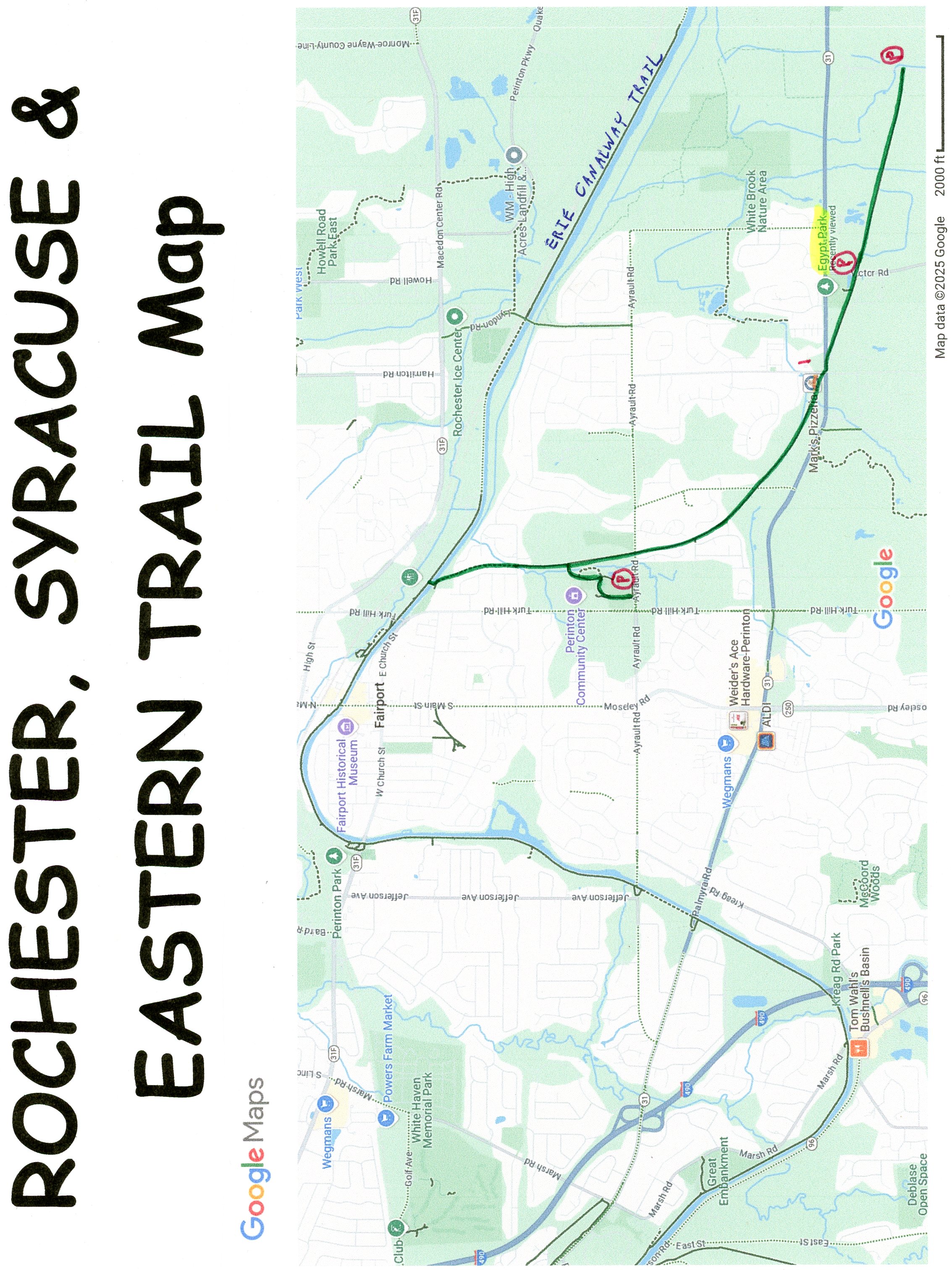
To Start from the Pannell Road parking lot in Perinton [Southern End]; From I-490 take exit 26 to Route 31 east for 5.5 miles. Turn right on Pannell Circle. Follow to Pannell Rd and turn right. The parking lot will be on your right.
To Start from Egypt Park in Perinton [Southern Section]; From I-490 take exit 26 to Route 31 east for 4.5 miles. Turn right on Victor Rd. The park entrance is on your right. At the far end of the parking lot is a spur trail out to the main trail.
To Start from Center Park in the Fairport Village of Perinton [Northern Section]; From I-490 take exit 26 to Route 31 east for a 1/4 mile. Turn left on Route 21 and travel 2.5 miles east to the parks entrance. From the end of the parking lot follow the paved trail straight for 0.3 miles to the main trail.
The Rochester, Syracuse & Eastern Trail follows an abandoned rail bed that once carried two electric trolley lines operated by the Rochester, Syracuse, and Eastern Rapid Railroad from 1906 until 1931. The trail travels from Perinton, Northwest, to the Fairport Village section of Perinton, where it connects to the Erie Canalway Trail; Syracuse-Rochester .
Starting from the Pannell Road parking lot in Perinton [Southern End]; I haven't checked out this section. The wide, stone-dust rail trail heads West, along an open and wooded corridor. Cross Victor Rd (Use Caution; high speed road) and you'll come to a side trail at 1.2 miles on your right leading to the Egypt Park parking lot in Fairport Village. Come to Route 31 at 1.6 miles and head left along the sidewalk to a traffic light across route 31, then left across Mason Rd. Head right to pick up the trail on your left. Here the trail travels North, along an industrial corridor, crossing Hogan Rd at 2.4 miles where you travel along a residential corridor before crossing Ayrault Rd (Route 21) (Use Caution; high speed road) at 3.2 miles. I've checked out this section. Pass by a Spur Trail on your left at 3.5 miles before crossing Pebble Hill Rd.
Note; This paved Spur Trail crosses an iron bridge over a creek, winds through the woods and brings you to Center Park where you'll find an amphitheatre, play ground, picnic pavilion and Porto-Potty's. Come to the Center Park parking lot after 0.3 miles.
Continuing North, you cross Pebble Hill Rd and soon come to the Erie Canal, where a series of bridges take you across the Erie Canal, down a ramp to the Erie Canalway Trail; Syracuse-Rochester at 4.3 miles.
HH
BEFORE YOU SET OUT BE SURE TO READ THE
WAIVER OF RESPONSIBILITY AND DISCLAIMER
BIKE IT OR HIKE IT