ONONDAGA CREEKWALK:
SYRACUSE, NEW YORK
-BIKE IT OR HIKE IT-
Last Updated: March 07, 2025
Length: Onondaga Creekwalk;
Difficulty: Easy. Flat paved & cement trail.
Directions:
To Start from the Destiny USA parking lot [Northern End]; From I-81:
Northbound take exit 23 to park St and turn right. First right on Hiawatha Blvd. Come to the mall on your right. Turn left on Solar St and take your first right into the parking lot. The trail is along your right, between the parking lot & Hiawatha Blvd.
Southbound take exit 23B to Destiny USA Dr and turn left. Travel past the mall and left out to Hiawatha Blvd. Cross the Blvd to Solar St and take your first right into the parking lot. The trail is along your right, between the parking lot & Hiawatha Blvd.
To Start from the Van Renssellaer Street parking lot [Northern Section]; From I-690:
Westbound take exit 10 to N Geddes St and turn right. Follow to Van Renssellaer St and turn left. The parking lot is on your right.
Eastbound take exit 9 straight onto Bear St. Take your 3rd right onto Van Renssellaer St. Parking lot is on your left.
To Start from the Hunter Ave parking lot [Southern End]; From I-80:
Southbound take exit 17 to State St and turn right. Turn left on Colvin St and just after you cross Onondaga Creek turn right on Hunter Ave. Parking lot on your right.
Northbound take exit 17 and turn left underneath the interstate to S Salina St and head right for 0.6 miles. Turn left on Colvin St and just after you cross Onondaga Creek turn right on Hunter Ave. Parking lot on your right.
The Onondaga Creekwalk starts from the Southern End of Onondaga Lake and travels South, following Onondaga Creek through the Inner Harbor & downtown Syracuse. A short, unconnected section of the Onondaga Lake Park; Loop the Lake Trail, connects to the Northern End of the Onondaga Creekwalk. Part of the Northern Section is also utilized by the Erie Canalway Trail; Utica-Syracuse , which is part of the EMPIRE STATE TRAIL . For more information visit; ONONDAGA CREEKWALK .
Starting from Onondaga Lake [Northern End]; Benches, overlook the lake.
Note; A short, 0.3 mile section of the Onondaga Lake Park; Loop the Lake Trail travels Northeast, along the Southern End of Onondaga Lake through Murphy's Island. This section closes from Dec. 1 to March 31 every year to protect Bald Eagles. I have not checked out this new section. See; Onondaga Lake Park . Future construction will continue the trail Northwest, to Onondaga Lake Park, where the Loop the Lake Trail is complete.
The paved Onondaga Creekwalk travels Southeast, underneath an active RR bridge and along the East Side of Onondaga Creek. Benches and lampposts dot the trail. Travel underneath Hiawatha Blvd where the trail turns left, passing by the Destiny USA parking lots along your right at 0.4 miles. The cement trail then turns left and travels Southwest, alongside Hiawatha Blvd, crossing over Onondaga Creek where the trail turns left.
Note; If you continue straight, alongside Hiawatha Blvd, the cement trail will bring you to Van Renssellaer Street, where you can connect to the Erie Canalway Trail; Utica-Syracuse . This trail will also connect you to the Onondaga Lake Park; Loop the Lake Trail .
Turn left and continue Southeast, as the trail now travels along the West Side of Onondaga Creek. Travel underneath Bear St and you'll come to an intersection.
Note; Right, this paved trail leads to the Van Renssellaer Street parking lot. The Erie Canalway Trail; Utica-Syracuse , follows this trail out to Van Renssellaer Street, where it utilizes a BIKE LANE right, Northwest to Hiawatha Blvd. This trail will also connect you to the Onondaga Lake Park; Loop the Lake Trail .
The Onondaga Creekwalk/Erie Canalway Trail continues Southeast, along the West Side of Onondaga Creek. Come to your 1st intersection: Right brings you to the Progress Park parking lot. Continue straight and you'll pass through the Inner Harbor Amphitheatre before reaching a 2nd intersection at 1.2 miles.
Note; Turn left, East, to check out the Inner Harbor Park Trail. Cross the iron pedestrian bridge and follow the paved trail alongside an interesting building. Turn left down the ramp, then right along the brick lined Inner Harbor promenade. Follow the promenade around the harbor North, past a boathouse and two large earthen docks. Trail ends after 0.3 miles.
Straight brings you out to W Kirkpatrick St, so head right. This brings you to the Progress Park parking lot. Turn left, along a brick pathway and cross W Kirkpatrick St. The trail continues Southeast, past the stone Parks Dept. building and out to Spencer St. Turn left to reach a cross-walk. The trail travels alongside Maltbie St, before turning left back alongside the creek. Cross the creek over an old iron RR bridge at 1.5 miles. This bridge was built in 1911 by the Delaware, Lackawanna & Western RR. The trail now follows the East Side of Onondaga Creek through a more urban section. Pass by the Plum Street Bridge, where the trail turns to brick, as it travels by two more pedestrian bridges. You'll come to a ramp that leads down to the cement trail alongside the river.
Note; This is the Franklin Square area which contains old brick buildings and Franklin Square Park. Worth a side trip.
The trail then travels South, underneath I-690, before pulling away from the creek and out to and across W Genesee St. Head left, East, to N Franklin St and turn right, South. Cross Erie Blvd, then look back to spot the 1932 Art Deco Niagara Mohawk Building. Continue straight along N Franklin St and across W Water Street.
Note; The Erie Canalway Trail; Utica-Syracuse continues left, East, along W Water Street.
Head right along W Water Street, then left, to W Washington St. Across the street is the site of the old Washington RR Station. Head right, along W Washington St, to a plaza with granite blocks. Behind the maroon iron fence is the creek below. A cross-light will take you over W Washington St, where the trail continues straight, South. The creek is buried here. Turn left, across the creek, where a ramp brings you back along the East Side of Onondaga Creek. Cross W Fayette St and come to Walton Street at 2.5 miles.
Note; If you continue straight, across the street, the cement trail, it will bring you to W Jefferson St & Armory Square. Parking lot located here (Fee). If you travel left, along W Jefferson St, it will take you around the old brick Armory, which is now the site of the MUSEUM OF SCIENCE & TECHNOLOGY . Lots of places to grab a bite among the old brick buildings.
I haven't checked out this next section. Continue right, along Walton Street, across the creek, crossing the street where the trail continues straight, to S West St. Here, a 2 Way SEPARATED BIKE LANE, known as a "Cycle Track", travels South, underneath a RR bridge. Past Seymour St, a cement trail continues to W Onondaga St. Cross the street and continue left, where you'll pick up the paved trail on your right at at 3.2 miles. Map Board. You quickly pick up Onondaga Creek on your left. The trail continues South, along the West Side of Onondaga Creek. Cross Temple St, W Taylor St and Tallman St, before coming to Midland Ave. Head left, back across the creek, then right across the street, where the trail now travels Southwest, along the East Side of Onondaga Creek. Come to Rich St at 4.2 miles and turn right, back across the creek, then left into Onondaga Park along a 2 Way SEPARATED BIKE LANE. I believe the trail then follows Lower Onondaga Park Dr (Closed to cars?) South, along the West Side of Onondaga Creek, before you pick up the paved trail again, as the trail turns Southeast. The trail then pulls away from the road and travels underneath South Ave. Pass by a pedestrian bridge on your left.
Note; This pedestrian bridge crosses the creek to the Kirk Park Dr parking lot. Here you can access Kirk Park. Sports fields & courts, playground and community center.
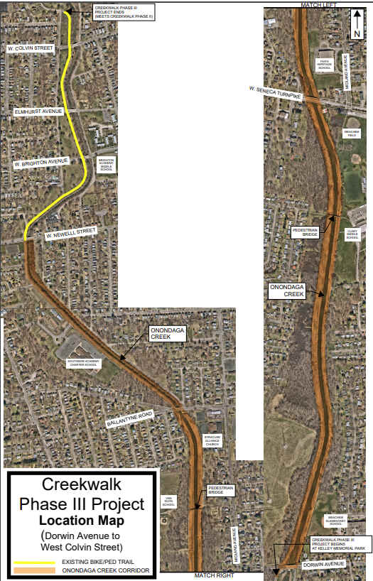
Come to Onondaga Creek Pkwy at 4.8 miles. Across the road is the Hunt Ave parking lot. The trail then utilizes Onondaga Creek Pkwy, which is closed to traffic, South. Cross W Colvin St, Elmhurst Ave & W Brighton Ave, before coming to W Newell St after 5.5 miles and the end of the trail.
Note; Phase 3 will continue the trail South, alongside Onondaga Creek, 3 miles to Dorwin Ave. Design phase 2025.
HH
CLICK HERE FOR ONONDAGA CREEKWALK MAP
CLICK HERE FOR EMPIRE STATE TRAIL MAP
BEFORE YOU SET OUT BE SURE TO READ THE
WAIVER OF RESPONSIBILITY AND DISCLAIMER
BIKE IT OR HIKE IT