MILL RIVER GREENWAY:
STAMFORD, CONNECTICUT
-BIKE IT OR HIKE IT-
Last Updated: May 222, 2025
Length: Mill River Greenway/Harbor Point/Kosciuszko Park Combined Loop; 7.3 mile Loop
Kosciuszko Park Loop Trail; 0.9 mile Loop
Scalzi Park Loop Trail; 0.9 mile Loop
Difficulty: Mill River Greenway; Easy. Flat, paved, stone-dust trail w/some on-road sections.
Kosciuszko Park Loop Trail; Easy. Flat, stone-dust trail.
Scalzi Park Loop Trail; Easy. Flat paved trail.
Directions:
To Start from the Kosciuszko Park parking lot [Southern End]; From I-95 take exit 7:
Eastbound: to Greenwich Ave. Continue straight along State St to Washington Blvd and turn right. Follow to Dyke Ln and continue straight to Elmcroft Rd and continue straight to the Kosciuszko Park parking lot.
Westbound: to N State St and follow to Washington Blvd and turn left. Follow to Dyke Ln and continue straight to Elmcroft Rd and continue straight to the Kosciuszko Park parking lot.
To Start from the Scalzi Park parking lot [Northern End]; From I-95 take exit 7:
Eastbound: to Greenwich Ave. Continue straight along State St to Washington Blvd and turn left. Travel 1.5 miles north to Bridge St and turn left. Enter the park on your left. Trail begins from the northeast corner of the park.
Westbound: to N State St and follow to Washington Blvd and turn right. Travel 1.5 miles north to Bridge St and turn left. Enter the park on your left. Trail begins from the northeast corner of the park.
The Mill River Greenway is a series of connected trails & BIKE LANES that start from Kosciuszko Park and travels North, to Mill River Park, where it follows the Mill River (Rippowam River) North, to Scalzi Park. The Mill River Greenway travels along both the Western & Eastern Sides of the Mill River, however it is not complete along both sides. Heading North, I follow the Eastern Side of the river and returning South, I follow the Western Side of the river, but switch river sides to bypass Gaps. For more information visit; MILL RIVER PARK .
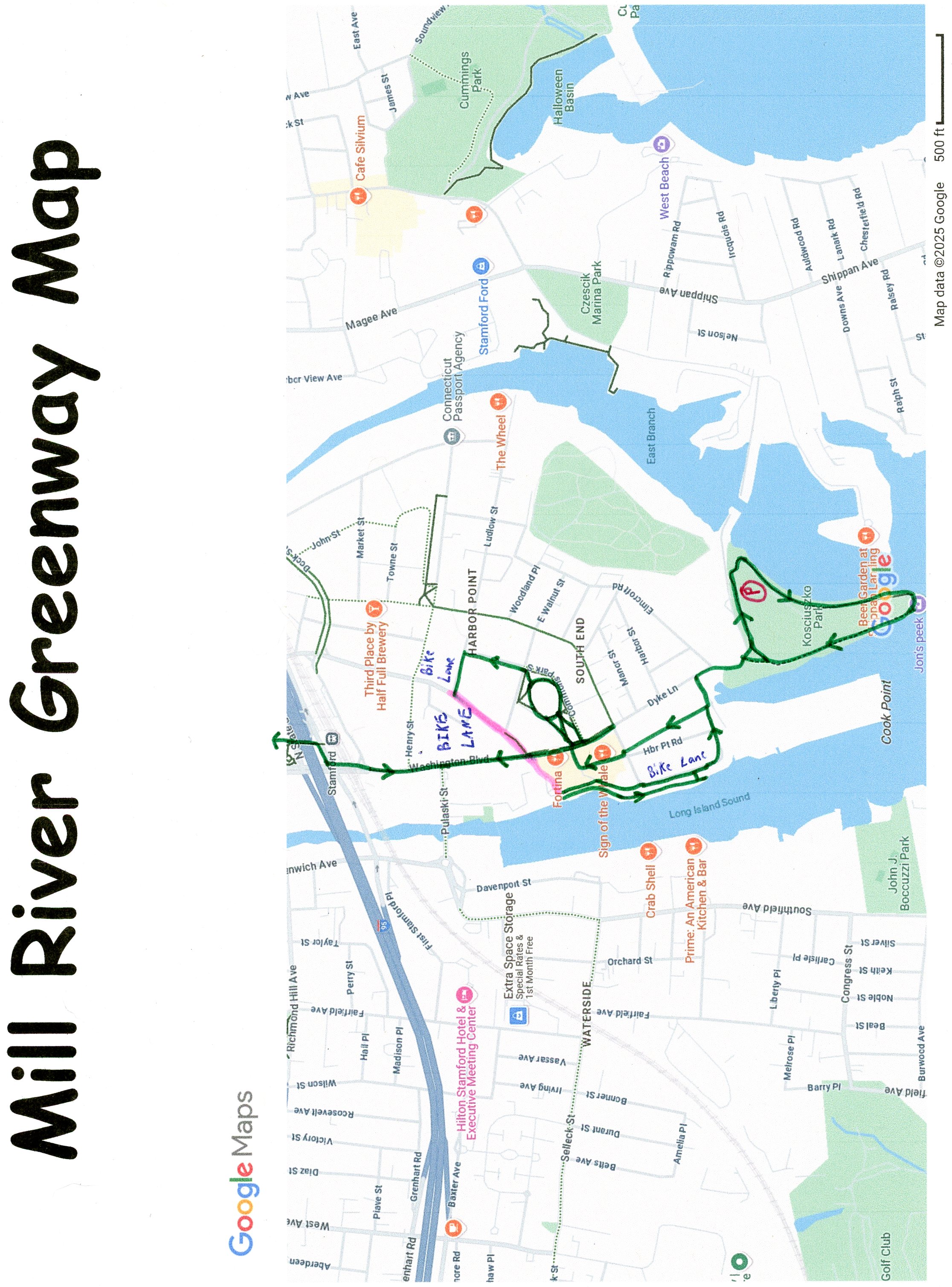
Kosciuszko Park Loop Trail:
Starting from the Kosciuszko Park parking lot [Southern End]; The stone-dust Kosciuszko Park Loop Trail begins here. Heading East, the trail comes to the East Branch of the Rippowam River, where the trail travels South, above the river. Pass by overlooks, picnic pavilion, and a playground, before traveling along meadows. Come to the Southern Tip of the park, where the trail is paved. Overlook of Stamford Harbor. The trail now travels North, along the West Branch of the Mill-Rippowam River, where it returns to stone-dust. Pass by a restroom and ball field, before coming to an intersection at 0.8 miles.
Note; Right, East, the stone-dust Kosciuszko Park Loop Trail returns to the Kosciuszko Park parking lot after a 0.9 mile Loop.
Harbor Point/Downtown Stamford Section:
[Continuing Mileage] Continue left to Elmcroft Rd, where a double-wide sidewalk takes you North, to Dyke Ln, which leads to Bateman Way. Travel left, along a BIKE LANE (double-wide sidewalk available) up Bateman Way to Harbor Point Road S & Pacific Street at 1 mile. This is Harbor Point development, which contains paved paths, boardwalks, residential & commercial buildings and many amenities. Travel right, North, along a BIKE LANE (one-way) on Harbor Point Rd S. A greenspace is along your left, with cement paths, benches, Triangle Park and playground. Cross Pacific St and continue on-road (low traffic/sidewalk available) before quickly coming to another median on your left (Harbor Point Square) with cement paths, tables & chairs and Map Board. Places to eat. Head right out to Washington Blvd. Cross to Harbor Point Commons Park, Map Board and veer right along the wide cement path. Pass by a playground and come to a water fountain. Travel around the right side and continue around the open grass area to an intersection at the Northern Side of the park. Bear right down to Walter Wheeler Dr, at 1.5 miles, where you'll follow a wide paved trail North, alongside Commons Park S to Woodland Ave. A BIKE LANE takes you left, West, to Atlantic Street. Head left, South, on-road (sidewalk available) back to Washington Blvd at 1.8 miles. Travel right, North, along the Washington Ave BIKE LANE and travel underneath a RR bridge to S State St at 2 miles. Cross the street and take an immediate right, along a wide cement path, which takes you underneath I-95 to N State St and the Stamford Gateway transportation center. Cross the street to Gateway Commons. Continue North, along a wide cement plaza, past the Stamford Cone, keeping to your right. Come to the front of the WWE headquarters and head left, West, past the giant WWE championship belt to Washington Blvd. Cross the Blvd and travel on-road, along Division St (sidewalk available) to Clinton Ave. Continue right, North, on-road (sidewalk available) to Tresser Blvd and cross. Head left, on-road (wide shoulder & sidewalk) across the Mill River and pick up the Mill River Greenway on your right.
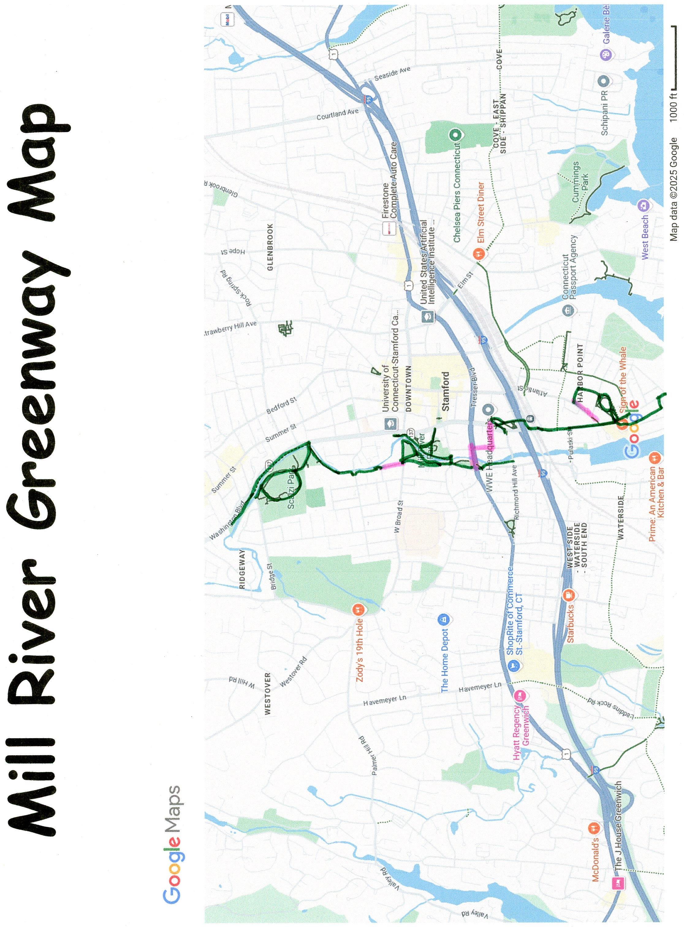
Mill River Greenway:
Eastern Side:
Note; This section of the Mill River Greenway was still under construction, as of May 2025. Detour North, along W Main St (wide sidewalk).
[Continuing Mileage] The wide, cement Mill River Greenway travels North, through the park, between W Main St and the Western Side of the river. It contains a playground, water fountains & picnic tables. Come to a *Red Pedestrian Bridge over the river at 2.7 miles. Cross this bridge, back over the river and continue North, along the Eastern Side of the river along the paved trail. Come to Mill River Park, where you'll find nice overlooks of the river. Several other trails traverse this park. Come to Broad Street at 3 miles. UConn Stamford campus located here. Cross the road and head left.
Note; A cement trail continues straight, but quickly ends at a UConn parking lot. Unfortunately, they didn't extend the trail between the parking lot and river. Missed opportunity.
Cross the river and continue on-road (no shoulder/sidewalk available) to Hanrahan St and travel right, on-road (one-way residential/sidewalk). Pick up the paved trail on your right at 3.3 miles. Map Board. Continue along the Western Side of the river, passing by a school playground and ball field, before coming to W North St.
Note; A pedestrian bridge crosses the river here, but doesn't really lead anywhere and has stairs at the end.
Cross the street, where the trail travels past a school, briefly sharing a school road and continuing alongside the river. Come to an **Intersection at 3.7 miles. Travel right, across a pedestrian bridge or the river to Washington Blvd. Here, a narrow, cement trail travels between the Eastern Side of the river and the road above. Come to Bridge St at 4.1 miles.
Note; The paved trail continues North, between the river and road, however it is in poor shape and quickly ends after 4.3 miles at Washington Blvd.
Instead, head left, along a sidewalk, across the river and pick up the paved Mill River Greenway on your left in the Scalzi Park.
Mill River Greenway:
Western Side:
[Continuing Mileage] The paved Mill River Greenway travels South, along the Western Side of the river through Scalzi Park. Travel past the restrooms (water fountain) and come to a parking lot.
Note; The paved Scalzi Park Loop Trail begins across the park road. I haven't checked out this trail. This 0.5 mile trail Loops around some ball fields & a playground, alongside the park road, returning here.
The trail travels alongside the parking lot, passing by some restrooms, before turning left, past the Scalzi Skatepark. Bear right.
Note; A paved trail travels left, East, before dead ending.
Travel down past a ball field, returning to the **Intersection at 4.6 miles. Return South, back to W Broad Street. Cross the road to the front of the Carousel Pavilion at 5.2 miles.
Note; A cement trail travels right, alongside Mill River St and another cement trail travels straight, through the park to the river, but has stairs.
Instead head left, along a wide cement trail, next to W Broad St to the river. Map Board. Here, the paved trail travels South, alongside the river. Very scenic and tranquil. Come to Mill River St, where you continue along the cement trail. This returns you to the *Red Pedestrian Bridge at 5.6 miles. Return South, back along W Main St, to Tresser Blvd.
Note; This section of the Mill River Greenway was still under construction, as of May 2025. Detour South, along W Main St (wide sidewalk).
Cross Tresser Blvd to a Map Board and continue alongside the river through Rotary Park to Richmond Hill Ave at 5.9 miles. Current end of the Mill River Greenway.
Harbor Point/Downtown Stamford Section:
[Continuing Mileage] Cross Richmond Hill Ave and continue South, on-road along Greenwich Ave (no shoulder/sidewalk available) past a cemetery. Travel underneath I-95, cross S State St and travel underneath a RR bridge to a traffic circle at 6.2 miles. Head left, across the Pulaski Street bridge and over the river where you'll pick up a BIKE LANE out to Washington Blvd. Travel right, South, returning along the Washington Ave BIKE LANE, back to Atlantic Street. Head right, on-road (low traffic/sidewalk available) to the end. Spot a ramp to your left. Travel up this ramp and out to a boardwalk at 6.6 miles, which overlooks the West Branch of the Mill-Rippowam River. Follow the boardwalk South, through Harbor Point and above the river. Boat docks, places to eat, pivnic tables, swings and overlooks. Come to Pacific St.
Note; A ramp leads down along the river, but brings you to a set of stairs that you'll have to carry your bike up.
Instead, follow a BIKE LANE (one-way) along Pacific St. You turn East, bringing you back to Harbor Point Road S & Pacific Street. Continue down to Dyke Ln at 7 miles. Head right, South, where a double-wide sidewalk continues along Elmcroft Rd, returning you to Kosciuszko Park and the stone-dust Kosciuszko Park Loop Trail. Continue East, along this trail, returning to the Kosciuszko Park parking lot after a 7.3 mile Loop.
HH
CLICK HERE FOR MILL RIVER GREENWAY SOUTH MAP
CLICK HERE FOR MILL RIVER GREENWAY NORTH MAP
CLICK HERE FOR MILL RIVER PARK MAP
BEFORE YOU SET OUT BE SURE TO READ THE
WAIVER OF RESPONSIBILITY AND DISCLAIMER
BIKE IT OR HIKE IT