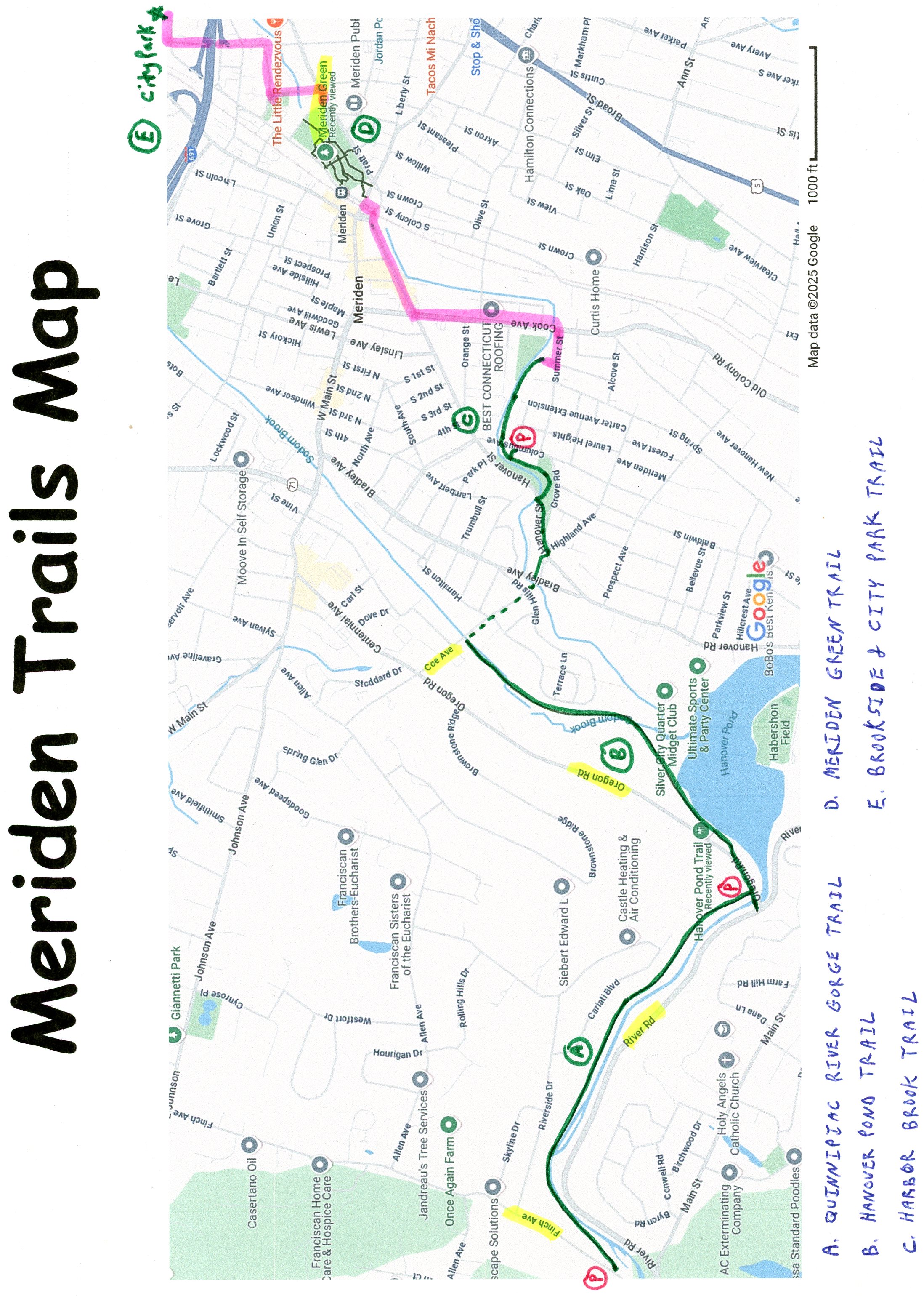
MERIDEN LINEAR TRAILS:
QUINNIPIAC RIVER GORGE TRAIL:
HANOVER POND TRAIL:
HARBOR BROOK TRAIL:
MERIDEN GREEN LOOP TRAIL:
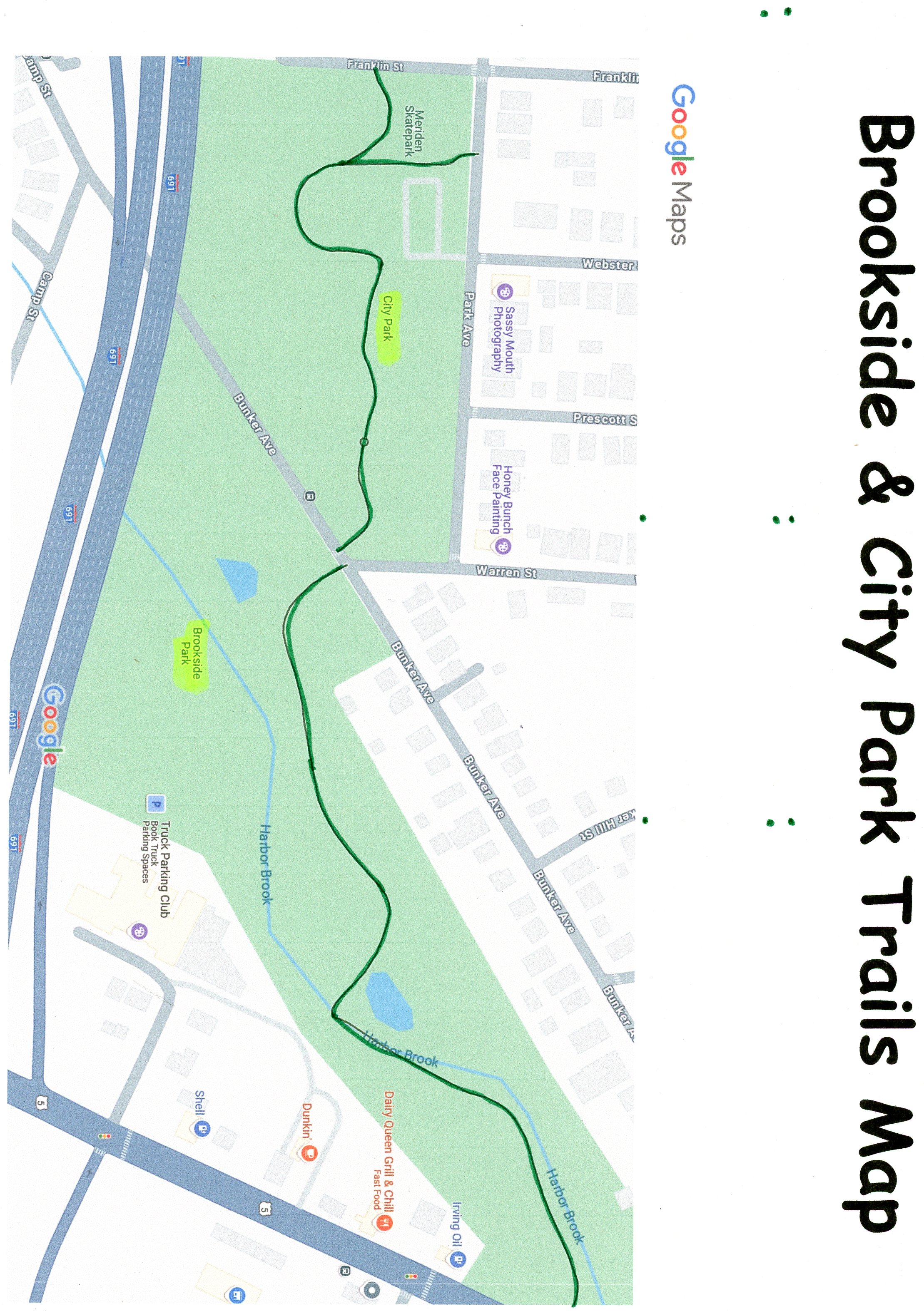
BROOKSIDE & CITY PARK TRAIL:
MERIDEN, CONNECTICUT
-BIKE IT OR HIKE IT-
Last Updated: July 23, 2025
Length: Meriden Linear Trail [Quinnipiac River Gorge-Hanover Pond-Harbor Brook Trails]; 3.4 miles combined
Quinnipiac River Gorge Trail; 1.3 miles
Hanover Pond Trail; 1.1 miles
Harbor Brook Trail; 0.6 miles
Meriden Green Loop Trail; 0.7 mile Loop
Brookside & City Park Trail; 0.6 miles
Difficulty: Quinnipiac River Gorge Trail; Easy. Flat, paved rail trail.
Hanover Pond Trail; Easy. Flat, paved rail trail.
Harbor Brook Trail; Easy. Flat, paved trail.
Meriden Green Loop Trail; Easy. Flat, cement trail.
Brookside & City Park Trail; Easy. Flat, cement trail & old paved road.
Directions: From Route 15 take exit 66 to Route 5 south. Turn right, on Route 68 and take your second right on Hanover St to Main St:
For the Quinnipiac River Gorge Trail [Western & Eastern Ends] & Hanover Pond Trail [Southern End]; Turn left on Main St and travel 0.5 miles. Turn right on River Rd and come to River & Oregon Roads.
The River Road parking lot is located next to the old "Red Bridge" for the Quinnipiac River Gorge Trail [Eastern End]. Right, just up Oregon Rd is the Oregon Road parking lot for the Hanover Pond Trail [Southern End].
Continue along Route 70 (River Rd) for another 1.5 miles and take a right onto Norton Ln and another right onto Cheshire St. Take your next right onto Sindall Rd, which becomes Finch Ave. The Finch Ave parking lot is on your right just past the Meriden Waterworks building.
For the Columbus Ave parking lot for the Harbor Brook Trail [Central Section]; Turn right on Main St, then left on Hanover Rd. Travel 1 mile and turn right on Highland Ave. Take your third left on Columbus Ave and travel 0.3 miles. Parking lot on the left.
The Quinnipiac River Gorge Trail, Hanover
Pond Trail & Harbor Brook Trail are all part of Meriden Trails.
The Quinnipiac River Gorge Trail & Hanover
Pond Trail follow the abandoned rail bed of the former Meriden
& Cromwell Railroad, which operated from 1885 to 1888 until its
name changed to the Meriden, Waterbury & Connecticut River
Railroad, when it was extended to Waterbury. In 1892 it became the New
York & New England Railroad. Water power was used to power industry along
the river including the Meriden Gorge Carpenters Dam, which fed a civil
war button factory. Larger dams created lakes such as Hanover Pond.
Between these 2 trails you'll find the 78 foot long "Red
Bridge" as it crosses over the river. The City of
The
Quinnipiac River Gorge Trail:
Starting from the Finch Ave parking lot [Western End]; Here you'll find the brick Meriden Waterworks building, built in 1914. The wide, paved Quinnipiac River Gorge Trail travels East, past a brownstone entrance column into the woods and alongside the Quinnipiac River. There are benches and informational signs located along the trail, as well as, Mileage Markers located every 0.25 miles. After 0.3 miles you'll come to a set of benches and the remnants of an old stone bridge abutment. Containing along the trail, which now travels between the river and high ledge, there will be benches on your right and the remnants of an old stone dam across the river. Pass by two brownstone entrance columns and come to a Map Board, Oregon Rd and the "Red Bridge" on your right after 1.3 miles. This is the Eastern End of the trail and the start of the Hanover Pond Linear Trail. Across the "Red Bridge" is the River Road (Route 70) parking lot.
Hanover Pond Trail:
Starting from the River Road/Oregon Road parking lots [Southern End]; [Continuing Mileage from the Quinnipiac River Gorge Trail] The paved Hanover Pond Linear Trail travels East, across Oregon Rd via a cross-light, then turns North, alongside a double-wide sidewalk. Just before the Hanover Pond parking lot the trail becomes paved as it takes you between the parking lot and Hanover Pond to a brownstone entrance column and Map Board at 1.5 miles. Storybook signs located here. The trail travels Northeast, briefly alongside the pond, with a nice overlook before coming to an intersection at 1.7 miles.
Note; A dirt path to your right travels East, alongside the pond.
You'll cross over Sodom Brook twice, as the trail follows the power line. Pass by a parking lot for Platt High School and out to Coe Ave at 2.4 miles. The old rail bed is undeveloped past here.
Note; [Continuing Mileage] To connect to the Harbor Brook Trail travel right, Southeast, on-road along Coe Ave (wide shoulder & sidewalk). Cross Harbor Brook and Bradley Ave where a wide paved trail takes you up to and across Hanover Street. Head left, East and you'll come to a Map Board and brownstone column for the paved Harbor Brook Trail at 2.8 miles.
Ha
rbor Brook Trail:[Continuing Mileage] 911 Call Boxes located along this trail. The paved Harbor Brook Trail travels East, along the Southern Side of Hanover Street, before veering right, above Harbor Brook, below along your left. The partially shaded trails travels between the tree line and river North. Come to an intersection at 3 miles.
Note; Right, will take you up to the Columbus Ave parking lot. Brownstone entrance column & Map Board.
Continue straight, along the river and travel East, through a tunnel underneath Columbus Ave. The trail ends after 3.4 miles at Summer Pl. Map Board.
Note; 2 more sections of the Harbor Brook Trail are located Northeast and travel through the Meriden Green & Brookside Park, however, an on-road detour is necessary. [Re-zeroing Mileage] Travel out Summer Pl to Summer St (residential) and head left, on-road to Cook Ave. Head left, North, along Cook Ave (wide shoulder) to Hanover St at 0.5 miles. Head right, Northeast, along Hanover St (no shoulder) to Perkins St and turn right, crossing some RR tracks. Turn left on State St to E Main St and cross over to the start of the Harbor Brook Trail; Meriden Green Trail after 0.9 miles.
Harbor Brook Trail; Meriden Green Trail:
Starting from E Main & State Streets [Southwest Corner]; The buried Harbor Brook emerges at the Southwest Corner of the Green. Harbor Brook used to be buried through the park, which was once a contaminated brownstone site, but was uncovered when they built the Green.
3 Trails travel Northeast, through the park, creating several Loops. Check out the Meriden Green Map Below. The Orange Trail (along the Northern Side of the Green), the Yellow Trail (through the center of the Green) and the Blue Trail (along the Southern Side of the Green). A Pedestrian Bridge cuts through the middle (North-South) of the Green.
Heading Northeast, the double-wide cement Orange Trail, travels between State St and the brook, along the Northern Side of the Green. Pass by a Spur Trail on your right.
Note; This Spur Trail crosses the brook to the Yellow Trail (center trail).
Continuing straight, the trail briefly splits, as it travels underneath a Pedestrian Bridge. Come to another intersection and Spur Trail on your right.
Note; This Spur Trail crosses the brook to the Yellow Trail (center trail).
Continue straight, to another intersection. Left takes you out to State St and the top of an amphitheater. Bare right, past an amphitheater, to Mill St after 0.3 miles. Restrooms. Head right, South, following a sidewalk to Pratt St.
Note; 2 Options from here:
Option 1: Complete the Loop. Take the 2nd trail off Pratt St (1st trail has stairs) and travel Southwest, along the Blue Trail (along the Southern Side of the Green) & Yellow Trail (center trail). Return to the brook and come to an *Intersection and a Spur Trail.
Note; This Spur Trail crosses the brook to the Orange Trail (along the Northern Side of the Green).
Option 1a: From this *Intersection the Yellow Trail (center trail) continues straight, alongside the brook, traveling underneath the Pedestrian Bridge to an intersection and a Spur Trail.
Note; This Spur Trail crosses the brook to the Yellow Trail (center trail).
Continue straight and come to another **Intersection.
Note; A Spur Trail straight, leads to the Southeast Corner of the Green and Pratt & E Main Streets.
Note; The Blue Trail comes in from the left.
The Yellow Trail & Blue Trail both bare right, returning to the Southwest Corner after a 0.7 mile Loop.
Option 1b: From this *Intersection the Blue Trail bares left, to another intersection.
Note; A Spur Trail left, leads to both Pratt St, as well as, a ramp up to the Pedestrian Bridge. This bridge takes you North, 0.3 miles over the Green & Harbor Brook to State St and the Meriden RR Station.
Continue straight, underneath the Pedestrian Bridge, along the Southern Side of the Green, to an **Intersection.
Note; A Spur Trail left, leads to the Southeast Corner of the Green and Pratt & E Main Streets.
Note; The Yellow Trail comes in from the right.
The Yellow Trail & Blue Trail both bare right, returning to the Southwest Corner after a 0.7 mile Loop.
Option 2: Connect to the Harbor Brook Trail; Brookside & City Park Trail via an on-road detour. [Re-zeroing Mileage] Head left, following a sidewalk alongside Pratt St to Cedar St (low traffic) and continue left on-road, crossing over Harbor Brook, before coming to Park St (low traffic) and heading right. This brings you to Center St. Head left, on-road (no shoulder) and travel underneath I-691 to Park Ave. Head right, (low traffic), crossing Franklin St and coming to City Park after 0.7 miles.
Harbor Brook Trail; Brookside & City Park Trail:
Starting from Park Ave [Western End]; [Re-zeroing Mileage] The wide, cement Harbor Brook Trail; Brookside & City Park Trail travels South, past a Splash Park, Skate Park & playground, before turning East, winding through the park. Cross Bunker Ave to Brookside Park at 0.2 miles, where you follow an old paved road East, through this open park. Come to an old parking lot where the trail splits. Continue right, along a rough gravel trail, crossing a stone bridge over Harbor Brook. Continue alongside the brook along a rough stone-dust and large gravel trail. Pass by another stone bridge at 0.5 miles.
Note; You can Loop back to the old parking lot by crossing this bridge and traveling West.
Trail continues out to Route 5 after 0.6 miles.
HH
CLICK HERE FOR QUINNIPIAC RIVER GORGE TRAIL MAP
CLICK HERE FOR QUINNIPIAC RIVER GORGE TRAIL MAP
CLICK HERE FOR HANOVER POND TRAIL MAP
CLICK HERE FOR HANOVER POND TRAIL MAP
CLICK HERE FOR HANOVER POND TRAIL; MERIDEN GREEN SECTION
CLICK HERE FOR BROOKSIDE & CITY PARK TRAIL MAP
CLICK HERE FOR MERIDEN LINEAR TRAIL MAP
BEFORE YOU SET OUT BE SURE TO READ THE
WAIVER OF RESPONSIBILITY AND DISCLAIMER
BIKE IT OR HIKE IT