LITCHFIELD COMMUNITY GREENWAY:
LITCHFIELD, CT
-BIKE IT OR HIKE IT-
Last Updated: July 17, 2025
Length: Litchfield Community Greenway; 2.1 miles
Difficulty: Easy. Flat crushed gravel trail. White Memorial Section hard packed dirt & gravel.
Directions:
To Start from the North Shore Road parking lot [Southern End]; From the junction of Routes 63 & 202 in Litchfield travel west on Route 202 for 2.6 miles. Turn left on North Shore Rd. Parking lot on the left.
The Litchfield Community Greenway follows portions of the old Shepaug, Litchfield & Northern RR, a short independent RR that was chartered as the Shepaug Valley Railroad in 1868 and operated from 1872 to 1891 when it was taken over by the Housatonic Railroad. In 1898 the Housatonic operation was assumed by the New York, New Haven & Hartford Railroad (NH). As the Litchfield Division of the NH the line was operated until abandonment in 1948. The trail will start in Litchfield from the old Litchfield RR Depot, which is the headquarters for the Litchfield Land Trust. It will travel South, along the old rail bed. Here the trail continues Southwest, along the old rail bed. It then detours off the old rail bed and travels South, then West, through the White Memorial Conservation Area. It then turns Southwest, back along the old rail bed to Bantam (Borough of Litchfield). Future construction will continue the trail West, through Bantam.
For more information visit; LITCHFIELD COMMUNITY GREENWAY and WHITE MEMORIAL CONSERVATION CENTER .
Starting from North Shore Road parking lot in Litchfield [Southern End]; Map Board located here, along with maps. This is on the border with Bantam (Borough of Litchfield)
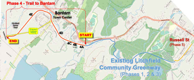
Note; Future Phase 4 will continue the Greenway West, through the borough of Bantam. Construction slated for 2025. See Map Below.
Heading North, the narrow, crushed gravel Litchfield Community Greenway enters the woods. Butternut Brook wetlands along your right. Part of the White Memorial Conservation Area. The trail comes alongside Route 202 before crossing a bridge over Butternut Brook. Map Board. Next the trail turns right away from the road, passing a sub-station and crossing Whitehall Rd (entrance road for White Memorial Conservation Center) at 0.5 miles. Here you briefly pass through a Pine forest before crossing Bissell Rd (cross-light) to a boardwalk. Follow the boardwalk alongside Bissell Rd South, to an entrance for the White Memorial Conservation Area. Map Board for White Memorial Conservation Area located here. Travel past the gate along a hard packed dirt, grass and gravel trail through a wooded corridor. Some root issues. Lots of intersecting paths. Green triangular signs mark the route, however there are no arrows at intersections so pay attention. Turn right, East, at the first intersection. Continue straight past Duck Pond, where a boardwalk heads left around it (No Bikes). Head left, North, at the next intersection. Stay straight when the Red Trail turns right. This will take you out of the woods and along Mallard Marsh at 1.4 miles. Crushed gravel trail follows a causeway. Cross a small bridge and pass another White Memorial Conservation Area Map Board as you exit the marsh. To your left you'll spot where the old RR bed traveled through the marsh. Cross Whites Wood Rd and you'll come to another Map Board. Here the crushed gravel trail follows the old RR bed East, along a causeway through more marsh. Pass a cemetery along your left before reaching the currant end of the trail after 2.1 miles at the intersection of Whites Wood Rd, Lake St and Russell St. Map Board and benches here.
Note; The old rail bed continues North, alongside Russell Rd, but has not been developed as of 2024. Phase 5 construction is planned for 2025 to extend the trail North, along the old rail bed to the old Litchfield RR Depot, which now houses the Litchfield Land Trust. A new parking lot will be built here as well.
HH
CLICK HERE FOR LITCHFIELD COMMUNITY GREENWAY MAP
CLICK HERE FOR WHITE MEMORIAL CONSERVATION MAP
BEFORE YOU SET OUT BE SURE TO READ THE
WAIVER OF RESPONSIBILITY AND DISCLAIMER
BIKE IT OR HIKE IT