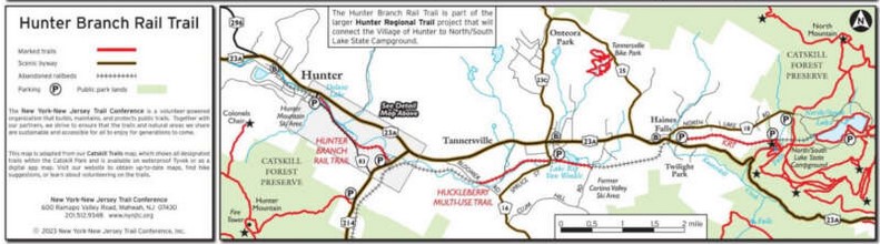
HUNTER REGIONAL TRAILS:
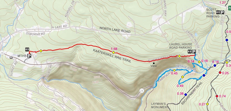
KAATERSKILL RAIL TRAIL:
PALENVILLE to HAINES FALLS, NEW YORK
HUCKLEBERRY TRAIL:
TANNERSVILLE, NEW YORK
HUNTER BRANCH RAIL TRAIL:
HUNTER, NEW YORK
-BIKE IT OR HIKE IT-
Last Updated: August 24, 2025
Length: Kaaterskill Rail Trail; 1.6 miles
Laurel House Trail; 0.3 miles
Huckleberry Trail; 2.1 miles
Hunter Branch Rail Trail; 1.8 miles?
Difficulty: Kaaterskill Rail Trail; Moderate to difficult. First section still has old RR ties in place. Crushed gravel & dirt rail trail.
Laurel House Trail; Moderate. Steep, stone-dust trail.
Huckleberry Trail; Moderate. Flat, hard packed gravel rail trail. Mountain bike recommended.
Hunter Branch Rail Trail; Eastern Section: Moderate. First short section still has old RR ties in place. Hard packed dirt and grass rail trail with some tree roots.
Hunter Branch Rail Trail; Western Section: Easy. Flat, paved trail. On-road Section between Eastern & Western Sections.
Directions:
From I-87 take exit 20 to Route 32 northwest. In Saxton, turn left onto Route 32A. In Palenville, take Route 23A northwest into the Catskills. Very scenic drive to Haines Falls.
To start from the Mountain Top Historical Society in Haines Falls [Kaaterskill Rail Trail; Western End]: Just after you enter Haines Falls spot the Welcome Center (Mountain Top Historical Society) on your right. Follow road to parking lot. A path north takes you to the old Haines Falls RR Station and trailhead.
To start from the Laurel House Trail parking lot in Palenville [Kaaterskill Rail Trail; Eastern End]: Continue west along Route 23A and take your first right along N Lake Rd. Turn right on Route 18 and follow for 1.7 miles. Turn right on Laurel House Rd and follow to parking lot.
To start from Rip Van Winkle Lake in Huckleberry [Huckleberry Trail; Center Section]; Continue west 1.7 miles along Route 23A from N Lake Rd in Haines Falls to Tannersville. Take a left down S Main St which will run into Railroad Ave. Park at the Lake, where the trail passes through.
To start from Bloomer Road in Huckleberry [Huckleberry Trail; Western End]; Continue west 2 miles along Route 23A from S Main St. Turn left on Bloomer Rd. Just before Gooseberry Creek you'll see the trailhead on your left. Just past here spot a pullout on your left for a couple of cars.
To start from Stoney Clove Road in Hunter [Hunter Branch Rail Trail; Eastern End]: Continue west 0.7 miles along Route 23A and turn left on Route 214. Cross Schoharie Creek and turn right on Stoney Clove Rd. Parking for a few cars..
To start from Dolan's Lake in Hunter [Hunter Branch Rail Trail; Western End]: Continue west 1.8 miles along Route 23A to Hunter and turn left on Route 83. Take your first left into the Dolan's Lake parking lot.
The Hunter Regional Trail is a network of rail trails that run along a former railroad corridor in Hunter, NY. During its peak in the late 1880s and early 1900’s, the trains would run from Kingston and bring visitors to local hotels such as the Catskill Mountain House and the Hotel Kaaterskill. Starting from the East, the Kaaterskill Rail Trail begins at the historical Ulster & Delaware Train Station, built in 1913, that serves as headquarters for the Mountain Top Historical Society and offers a small museum and information center. The rail-trail continues East along the former U&D RR, which once took tourists through the area, into the Kaaterskill Wild Forest to end at the top of Kaaterskill Falls, one of the highest waterfalls in the state. A new footbridge built by New York State DEC crosses Spruce Creek (Lake Creek) above Kaaterskill Falls and now links the rail-trail to the Escarpment Trail. To the West, the Huckleberry Trail (also known as the Tannersville Bike Path) runs East-West, along the former Huckleberry Line Railroad bed, originally owned by the Ulster & Delaware and Canajoharie & Catskill Lines. Finally, further West, the Hunter Branch Rail Trail travels from Stoney Clove Rd, Northwest, along a segment of the Hunter Branch of the Stony Clove and Catskill Mountain RR, which was discontinued in 1939. The trail continues on-road along Ski Bowl Rd (Country Road 83) to Dolan's Lake in the Village of Hunter. For more information check out; HUNTER REGIONAL TRAILS & KAATERSKILL RAIL TRAIL .
Kaaterskill Rail Trail:
Starting from the Mountain Top Historical Society parking lot in Haines Falls in Palenville [Western End]; Map Board. A gravel road will take you up to the old rail bed and some Porto-Potty's.
Note; Heading West, the old rail bed is undeveloped and quickly disappears.
Heading East, the crushed gravel Kaaterskill Rail Trail, passes by the old RR Depot and some old RR tracks, before heading into the woods.
Note; This first section can be tough, as the old RR ties are still embedded in the trail. Not recommended for kids on bikes. For the most part, a single track along the edges will help you avoid them.
The surface consists of crushed gravel, hard packed dirt, some tree roots and stumps. After 0.8 miles the trail improves. Soon, a steep drop is along your right. Come to the Laurel House Road parking lot after 1.6 miles. Map Board & Porto-Potty's.
Note; You may continue South, downhill, along the switch-back, stone-dust Laurel House Trail, to view the top of Kaaterskill Falls after 0.3 miles. Informational signs.
Huckleberry Trail:
Starting from Bloomer Road in Huckleberry [Western End]; The Huckleberry Trail starts just up the road from the pullout near a wooden railing. The crushed gravel rail trail heads East, into the woods and brings you alongside a green fence. Down below is Gooseberry Creek. You'll cross Allen Lane (parking area) followed by a wooden bridge at 0.5 miles and enter a Hemlock forest with a wooden fence along your left and the creek below to your right. Continuing along the trail, after 0.9 miles, pass by a nice Pine forest along your right overlooking Gooseberry Creek. Nice spot to check out the creek. After crossing a wooden bridge, you then cross Railroad Ave to Rip Van Winkle Lake Park parking lot. The stone-dust trail continues past sports courts, skate park, picnic pavilion, playgrounds and restrooms to Rip Van Winkle Lake at 1.3 miles. Bike Rentals. Another bridge takes you across the creek, into the woods and back along the rail trail as it parallels the lake. The trail eventually veers off the old rail bed and ends at Clum Hill Rd after 2.1 miles.
Hunter Branch Rail Trail:
Starting from Stoney Clove Road in Hunter [Eastern End]; A gravel path takes you up to the old rail bed.
Note; Heading Southeast, the old RR used to cross Stoney Clove Rd (you can still see the old stone abutment).
The flat, hard packed dirt & cinder Hunter Branch Rail Trail follows a berm to a pedestrian bridge over the Schoharie Creek before entering the woods. The trail travels Northwest, along the old rail bed and above Schoharie Creek below right.
Note; As of June 2024, this section still has old RR ties in place, making for a difficult, bumpy ride. However, plans call for improving the trail in the future.
This is a short rough section, which includes a rock cut, past which the trail improves at 0.3 miles. The hard packed dirt, grass and some tree roots trail continues. At 0.8 miles you come to Ski Bowl Rd (Route 83) and must continue right, on-road. Low traffic, but no shoulder. You then come alongside Schoharie Creek. Come to a pedestrian bridge across the creek and pass through a gap in the wooden fence to rejoin the trail at 1.3 miles.
Note; If you cross the bridge it brings you to Ferraro Rd, which leads out to Main St (Route 23A). Not sure how this bridge fits into future trail plans?
The paved trail continues along the Western Side of Dolans Lake.
Note; The Map shows the Hunter Branch Rail Trail following the Eastern Side of Dolans Lake, however, it is a grass trail. It will bring you to Dolans Lake parking lot.
The trail passes by benches, picnic tables and a picnic pavilion, where it follows alongside the road. All along your left is Hunter Mountain . Cross a small bridge and come to an intersection.
Note; Straight will bring you to Dolans Lake parking lot after 1.7 miles.
If you head left, you'll cross Route 83 to a pavers path that travels right, across a pedestrian bridge over Schoharie Creek, to Main St (Route 23A) after 1.8 miles.
HH
CLICK HERE FOR HUNTER REGIONAL TRAIL MAP
CLICK HERE FOR KAATERSKILL RAIL TRAIL MAP
CLICK HERE FOR HUCKLEBERRY TRAIL MAP
CLICK HERE FOR HUNTER BRANCH RAIL TRAIL MAP
BEFORE YOU SET OUT BE SURE TO READ THE
WAIVER OF RESPONSIBILITY AND DISCLAIMER
BIKE IT OR HIKE IT