HOOKSETT RAIL TRAIL:
HOOKSETT RIVERWALK TRAIL:
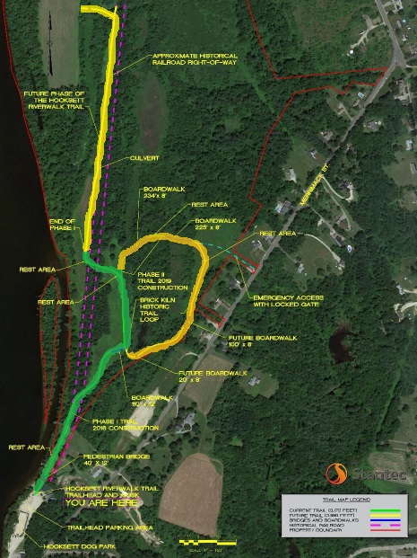
BRICK KILN HISTORIC LOOP TRAIL:
HOOKSETT SKYLARK BRIDGE:
HOOKSETT, NEW HAMPSHIRE
ALLENTOWN RAIL TRAIL:
ALLENSTOWN, NEW HAMPSHIRE
-BIKE IT OR HIKE IT-
Last Updated: September 21, 2025
Length: Hooksett Rail Trail; 1.6 miles
Hooksett Riverwalk Trail; 1.5 miles
Brick Kiln Historic Loop Trail; 0.3 miles
Allentown Rail Trail; 0.6 miles
Difficulty: Hooksett Rail Trail; Easy. Flat, stone-dust rail trail.
Hooksett Riverwalk Trail; Easy, stone-dust trail.
Brick Kiln Historic Loop Trail; Easy, stone-dust & boardwalk trail.
Allentown Rail Trail; Easy. Flat, stone-dust rail trail.
Directions:
From I-93 take exit 11 to Hackett Hill Rd and turn left. Take your next left onto W River Rd and follow to Main St. Right on Main St crossing over the river to College Park Dr.
Hooksett Skylark Bridge [Southern End]; Continue straight along College Park Dr and take your first left on Merrimack St. Take your first left on Veterans Dr. Park on right. Unfortunately they haven't built a dedicated parking area.
Hooksett Riverwalk Trail [Southern End]; Continue straight along College Park Dr and take your first left on Merrimack St. After 0.8 miles turn left at the Hooksett Dog Park sign. Trailhead parking is just past the Dog Park.
Hooksett Rail Trail; Continue straight along College Park Dr to Route 3 and turn left. Travel a mile and look right for the dirt parking lot.
The Hooksett Rail Trail, also known as the Heads Pond Trail travels North-South, along the old rail bed of the former Concord & Portsmouth Railroad which was founded in 1845 to build an East-West railroad line, connecting the ports of the seacoast to the capital city of Concord. The following year, a Branch Line from Hooksett to Suncook was granted to supply service to Suncook and surrounding towns.
The Hooksett Riverwalk Trail utilizes part of a spur line that connected the old Concord & Montreal Railroad to the Concord & Portsmouth Railroad, from where it crossed the Merrimack River (just above the falls) in Hooksett. It then utilizes the Concord & Portsmouth Railroad to the Allentown border, where the Allentown Rail Trail continues North, along the old rail bed. The Brick Kiln Historic Loop Trail is a Loop off of the Hooksett Riverwalk Trail. The name commemorates the Head & Son Brick Yard that operated on and near this property from 1850 to 1930 and is depicted on the Hooksett Town Seal. Bricks made in Hooksett were used in building the Manchester mills. Beginning in 1830, rich clay deposits along the Merrimack River in Hooksett were mined to produce millions of bricks used across the region. Bricks were loaded above the falls on the Merrimack River and lowered via Locks through a Branch Canal on the West Side of the river. Remnants of a Branch Canal at Head's Brickyard. Later Railroad tracks were laid to the brickyards. Also, between these two trails I recommend a quick stop to check the out Hooksett Skylark Bridge, a pedestrian bridge that crosses over the Merrimack River, next to the old 1931 B&M RR trestle bridge. This used to be the Hooksett Village vehicle bridge (1909) before being replaced with the current Main St bridge. For information See; HOOKSETT RAIL TRAIL .
Hooksett Skylark Bridge:
From Veterans Drive [Southern End]; Informational signs and some old trusses located here. The pedestrian Hooksett Skylark Bridge travels North, across the Merrimack River. On your left is the old B&M RR trestle bridge. At the end of the bridge, on your left, are the old RR tracks and Robie's Country Store. On your right is the Hooksett Village water precinct building. The building was formerly owned by the B&M Railroad and survived the 1936 flood which inundated the area. Less than 0.2 miles long.
Note; Robie's Country Store is a historic store. As a business, the general store was in continuous operation between 1822 and 1997, the last 110 years under the ownership of the Robie family from 1887, from whence it gets its name. The current building, constructed in 1906 following a fire, is a rare regional example of a store with a "boomtown" facade. It has been a political stop for presidential candidates since the early 1950s. Robie's Country Store was added to the National Register of Historic Places.
Hooksett Riverwalk Trail & Brick Kiln Historic Loop Trail:
Starting from Hooksett Riverwalk Trailhead next to Dog Park [Southern End]; Kiosk & Map Board located here.
Note; Just South, of the entrance road is a dirt parking area. Here you can spot the old RR abutments in the Merrimack River where 3 covered RR bridges used to cross. See; COVERED BRIDGES OF NH . The old rail bed is now part of the entrance road.
The stone-dust Hooksett Riverwalk Trail travels North, along the old rail bed, crossing Browns Brook along the Merrimack River. Informational signs all along the trail. You pull away from the river as you travel through woods. Turn off the old rail bed and travel through open fields. Cross a boardwalk and come to an *Intersection at 0.3 miles.
Note; This is the start of the Brick Kiln Historic Loop Trail heading right, Northeast. This stone-dust trail crosses a bridge, followed by a boardwalk as it travels around wetlands, woods and open fields. Turn left, Southwest, along a couple more boardwalks and a bridge before returning to another **Intersection and the Hooksett Riverwalk Trail after 0.3 miles.
Heading left, North, from the *Intersection, along the stone-dust Hooksett Riverwalk Trail, you follow an open field to an **Intersection with a sign board at 0.5 miles.
Note; This is where the Brick Kiln Historic Loop Trail re-joins the Hooksett Riverwalk Trail.
Continuing left, West, you cross the old rail bed and come to a 3rd ***Intersection.
Note; Straight along a grass trail leads to a bench overlooking the Merrimack River.
The trail turns right, North, alongside a field. The old RR bed is in the woods along your right. Come to an intersection at 1 mile. This was as far as I traveled.
Straight brings you to the old RR bed. It then continues left, North, along the old rail bed, ending at the Allenstown town line after 1.5 miles.
Allentown Rail Trail:
[Re-zeroing Mileage] I have not checked out this section. The Allentown Rail trail continues North, along the old rail bed, ending at Ferry Street after 2.1 miles. Parking lot.
Hooksett Rail Trail:
Starting from Route 3 & 28 parking lot; A Map Board is located near a short gravel path down to the rail trail.
Heading left, Northeast; The stone-dust Hooksett Rail Trail passes through a large culvert underneath Routes 3 & 28 and ends at Pleasant St after 0.2 miles.
Note; The old Portsmouth & Concord RR bed continued Northeast, where it connected into the old Portsmouth to Manchester RR.
Heading right, Southeast; The stone-dust Hooksett Rail Trail travels Southeast, past a marsh on your left with Browns Brook traveling through it. Spot an information sign board located here and elsewhere along the trail. You'll soon leave the few houses on your right behind and travel into the deep woods. You come alongside scenic Lakins Pond at 0.2 miles. The trail opens up after 1.1 miles. After 1.4 miles you come to a bench overlooking a stunning vista of Heads Pond.
Note; The trail ends here, however, dirt and sand roads continue around this pond and out to places unknown. Not sure how much of the old rail bed is still navigable.
HH
CLICK HERE FOR HOOKSETT RIVERWALK TRAIL MAP
CLICK HERE FOR HOOKSETT RIVERWALK TRAIL/ALLENTOWN RAIL TRAIL/HOOKSETT RAIL TRAIL MAP
BEFORE YOU SET OUT BE SURE TO READ THE
WAIVER OF RESPONSIBILITY AND DISCLAIMER
BIKE IT OR HIKE IT