HERITAGE TRAIL:
HARRIMAN-MIDDLETOWN, NEW YORK
-BIKE IT OR HIKE IT-
Last Updated: August
30, 2025
Length:
Heritage Trail; 19.5 miles
Crane Park Loop; 1.6 miles
Difficulty:
Heritage Trail; Easy. Flat, paved rail trail.
Directions:
To start from Harriman
[Southeastern End]; From the junction of Routes 17
& 32 in Harriman follow Route 17 south. Travel underneath Route 6 and take
your 2nd right on Evergreen Rd. Turn left on River Rd and follow to N Main St.
Parking lot on your right.
To start from Monroe [Southeastern
Section]; From
I-87 (NY State Thruway) take exit 16 to Route 17 west. Take exit 130 to
Route 208 south.
To
start from the Orange & Rockland Road parking lot;
Take a right when you see a sign that reads "Village of Monroe" (This
is Orange-Rockland Rd). There are two parking areas on this road. The first will
be a Park & Ride Lot B on your left 0.3 miles along this road,
followed by a small trail parking lot on your left just past Lot A.
To
start from Airplane Park;
Continue along Route 208 south to Route 17M and turn left. Take your
first left onto Millpond Pkwy and the park is on the left.
To start from Goshen
[Central Section]; From I-87 (NY State Thruway) take exit 16 to Route 17 west
or from I-84 take exit 19A to Route 17 east. Take exit 124 to Route 207
north (Greenwich Ave). Next take a right down Green St
and a left on St. James Place. The parking lot is on the left across from the trail.
To start from Middletown
[Northwestern End]; From From
I-84 take exit 15B to Route 6 W/17M. Continue along Route
17M for 1.6 miles, then continue straight along Academy Ave to E Main St.
Turn right and quickly pass the trailhead on your right. Turn right into the Middletown
& NJ RR Depot parking lot.
The Heritage Trail, formally known as
the Orange Heritage Trail, follows the
former rail bed of the Erie Railroad. This railroad originated at Piermont,
NY
in 1832 and ended at Dunkirk
on the
Lake Erie. The line was completed to Goshen
in 1841 and extended to Middletown
in 1843. In 1962, the Erie Railroad
becomes the Erie-Lackawanna Railroad
and the Goshen-Monroe line is downgraded to local freight service. The last
train-run ended in 1983. The trail begins in Harriman and travels Northwest,
through Monroe-Chester-Goshen-New Hampton to Middletown. For more information
visit; HERITAGE TRAIL .
Starting from the River Road parking lot in Harriman
[Eastern End]; Porto-Potty located here.
The paved Heritage Trail travels alongside River Rd before heading left,
Northwest,
across a brook via an old RR bridge. Here the trail follows the old rail bed
along a wooded corridor. You cross into Monroe
where a small brook follows along your left. Pass by
a marsh and Mountain Lakes on your right. Travel
underneath Freeland St at 1.5 miles. Cross a bridge over Mapes Pl at 2.2 miles
where the trail travels through downtown Monroe. Beautiful
brick buildings. You'll pass by the 0 Mileage Marker. There are
Mileage Markers every ½ mile (they start in Goshen
and end in Monroe). The trail now travels above Millpond
Pkwy, passing by a park bench on your right and wood fence on your left at 2.6
miles.
Note; A
paved path takes you down to the Millpond Pkwy; Heritage Trail parking lot.
Pass by
Mileage
Marker 9.5, an informational board & granite benches on your
right, before come to a paved access path & kiosk on your left at 2.7 miles.
Note; This
paved path takes you down to the Airplane Park
parking lot (which has an old jet plane in it, hence the name). Crane
Park is across the road.
Note; You
can follow a 1 ½ mile Loop
Trail around Crane Park
from the Airplane Park
parking lot; A crosswalk over Millpond Pkwy brings you to the paved Crane Park
Loop Trail. Head right, West,
out to Route 17M. Here the trail
travels South, between Crane Park
and Route 17M, passing by Upper Monroe Pond
(gazebo on a small island in lake). Cross
Lake St, traveling alongside Lower Monroe
Pond. You pass a small gazebo and butterfly garden, before passing a small
stone dam and coming to Stage Rd at 0.9 miles. Head left, North, up Stage Rd
(sidewalk) and you’ll quickly return to the paved trail on your left as it travels
between Millpond Pkwy and Lower Monroe
Pond. Cross Lake St again and continue alongside Upper Monroe Pond. You’ll pass by the Millpond Pkwy; Heritage
Trail parking lot across the road at 1.3 miles. Return to the Airplane Park
parking lot after
a 1.6 mile Loop.
The Heritage Trail continues
Northwest. Police Bike Patrols monitor the trail.
Travel underneath Route 208 and after 3.5 miles you
pass by the Park & Ride Lot B parking
area. Across Orange & Rockland Rd is Orange-Rockland Lake. Just past 3.7 miles you'll spot an old RR
Mileage Marker JC50, meaning 50 miles to Jersey
City. These old RR Mileage Markers were
located every mile along the
railroad. You then pass by the Orange
& Rockland Road parking lot at 3.8 miles. Here the trail heads into the
woods and travels along a berm traveling underneath Routes 6 & 17 at 4.6 miles where
you’re afforded some great views of the rolling hills to your left. Cross an
old RR bridge over Craigville Rd (Route 51) with a parallel bridge next to it that still has
tracks laid out at 4.9 miles. This must have been a double wide railroad bed.
Continuing along the trail, after crossing over two more bridges, you travel
along a steeper berm as the trail becomes more remote. A Police sub-station sits
alongside the trail at 6.5 miles.
Note; This area is part of
the old Camp
Laguardia. In 1918
New York built a prison (Greycourt Women’s Prison, also known as the Farm
Colony at Greycourt) for young women following a sharp spike in female
criminal activity in New York City. In 1934, Greycourt
Women’s Prison was converted into Camp Greycourt, a work camp for
homeless men. Renamed Camp LaGuardia in 1935 after the NY Mayor. The camp
closed in November 2006.
Note; Another old rail bed (old Erie Railroad)
heads Northeast, from here through Blooming
Grove, Washingtonville to Moodna Viaduct,
a scenic railroad trestle in the Salisbury Mills section of
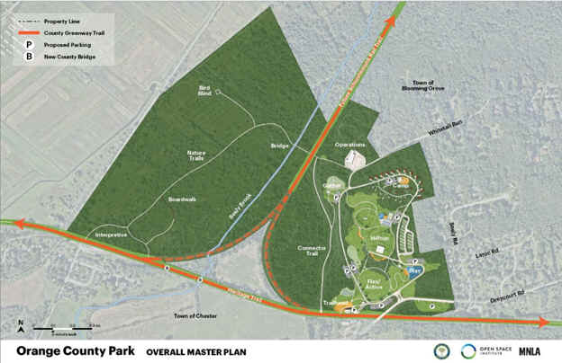
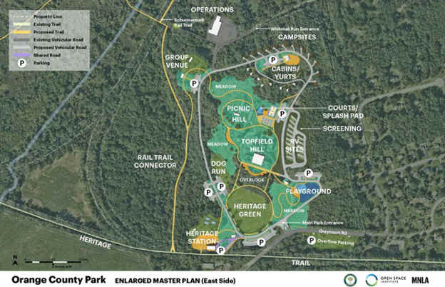
Cornwall. Phase
1 construction is underway in 2025 to convert the first 2.5
miles of the 10
miles of this old rail bed into the Schunnemunk
Rail Trail and turn Camp LaGuardia into
a Park. See Maps Below.

After crossing another old RR bridge over Seely
Brook, some old tracks are still laid out along the left side of the trail,
along with an old rail car and two flatcars. Next you pass below a railroad
trestle at 7.2 miles. The trail then passes through open fields and begins a
slight upgrade. You pass by the old Chester Railroad Depot at 8 miles (parking available here) in Chester
and travel through a rock cut with thick
stone block walls. Cross Black Meadow
Creek at 9.6 miles and Old Chester Rd at 10.1 miles. As the trail tops out at
11.5 miles, keep an eye out to your right to spot an old RR
Whistle Post. + See;
RR Whistle Post Below. You come to a Map Board at 11.8 miles and cross South St. Next you pass
by the 0 Mile Marker at 12 miles and finally come to the end of the paved trail
in Goshen at 12.3
miles. The Goshen parking lot is located
directly in front of you.
Note; No official trail currently takes you
through downtown Goshen, to connect to the
next section, which starts just off of W Main St. Continue straight
through the two Goshen parking lots and you'll come to Route 207 (Greenwich Ave).
Across the street is Railroad Ave (No crosswalk).
Head right to access a cross light. Follow Railroad Ave to W Main St. Use the cross-walk over to Grand St. Pass by
the gazebo type structure on your left and travel in front of the old Goshen
Train Station, now the Goshen Police Station. Just past the station turn left back along Railroad
Ave and head right. Continue straight on Railroad Ave through Northgate Manor
to a cul-de-sac. Continue straight
along a sidewalk and through a gate. Travel straight along a gravel road. This will bring you to a paved road. Continue
straight and you'll see the trailhead on your right past a gate at 13
miles.
The paved Heritage Trail continues
Northwest,
through an open wooded corridor, along the old rail
bed. Benches located all along the trail. Travel underneath Route 17 at
13.3 miles. Follow a causeway between a pond and large marsh. Travel past a Map
Board before crossing 6 1/2 Station Rd at 14.4 miles. You'll spot an old railroad box on your right,
just before you cross over an old double-tracked railroad bridge. Cross another
bridge, pass by a BIKE STATION then cross Hartley Rd at 15.3 miles.
Cross a bridge over a creek, followed by a bridge over the Wallkill River
to at 15.6 miles to New Hampton. Slight upgrade starts here. Cross a high bridge over a creek
before coming to the Route 50 parking lot on your right at 16.6 miles.
Place to grab some refreshments. Cross Ryerson Rd at 17.3 miles before traveling
underneath I-84. Cross Monhagen Brook before traveling through a
tunnel underneath Dolsontown Rd at 17.8 miles. Cross another bridge over a
brook. Large marsh on your right. You then briefly parallel some RR tracks on
your left before coming to Palmer Ave at 18.6 miles. Porto-Potty. You are now on the
outskirts of Middletown. The trail continue straight underneath a RR
bridge, with a shed underneath protecting riders from debris above. Cross an old
RR bridge over Genung St and cross Washington St at 19.6 miles. Cross Houston
Ave and another bridge over Sprague Ave, before coming along some active RR
tracks. Come to E Main St in Middletown
and the end of the trail after 19.5 miles.
Spot the old Middletown & NJ RR building on your right. The old rail
bed continues through town, but is no longer visible.
Note; You can
cross E Main St and travel through the parking lot to Railroad Ave, which was
either the old rail bed, or which follows alongside the old rail bed. You can
then either travel on-road along Railroad Ave, which curves left, West,
or travel through the parking lots (Caution one-way)
alongside it. Nice old brick buildings along the route. However, when you
reach Grove St, you'll need to follow the parking lots along your left, as
Railroad Ave continues straight. This will bring you to North St. Right leads
to a cross-walk. Across North St, enter Union St, but immediately turn left
through the Erie Station parking lot.
This will bring you to the old 1896 Erie RR Station, which now houses
the Middletown Thrall Library. Beautiful brick building. Informational
sign here about the old RR. Head left, along a cement walkway, between the
Library and another, smaller, old RR building to Depot St at 20 miles. Turn
right, along a brick walkway and follow it around the Library to James St. Across
James St you'll pick up a paved trail heading West,
through Erie Way Park. Skate Park, sports court and Porto-Potty. Come
to W Main St. Across the street is Hanford St and to the right of that is a
parking lot. Travel through this parking lot and you'll come to the old rail
bed after 20.2
miles.
Note:
The next phase, slated to begin in 2025, will extend the trail another 2.5
miles from West Main
St, West, along the
abandoned railroad bed, then turning North,
along the East Side of Monhagen Ave,
until it reaches Ingrassia Rd.
Old Railroad Equipment:
+
RR Whistle Post:
The Whistle Post,
was a post with a large "W" engraved or painted on it. This
meant the railroad engineers were to start sounding the trains Whistle.
The Whistle posts
were usually placed 0.25 miles
in advance of a road crossing,
bridges, tunnels and other points. Usually, there would be a post placed on both
sides of the crossing, covering both directions.
HH
CLICK
HERE FOR HERITAGE TRAIL MAP
BEFORE YOU SET OUT BE
SURE TO READ THE
WAIVER
OF RESPONSIBILITY AND DISCLAIMER
BIKE IT OR HIKE IT
HOME
PAGE