EAST ITHACA RECREATION
WAY:
SOUTH HILL RECREATION
WAY:
ITHACA, NEW YORK
-BIKE IT OR HIKE IT-
Last
Updated: August 17, 2025
Length: East Ithaca Recreation Way;
2.7 miles.
East Ithaca Recreation Way; Vincent
and Hanna Pew Trail; 0.8 miles.
South Hill Recreation Way; 5.7 mile Loop
Upper Trail: 2.3 miles.
Lower Trail (including
Connecting Trail): 1.1 miles.
Difficulty: East Ithaca Recreation Way; Easy. Flat paved rail trail with one steep
hill.
East Ithaca Recreation Way; Vincent
and Hanna Pew Trail; Moderate. Paved trail. One section flat, the other travels up a steep
hill.
South Hill Recreation Way; Slight grade. Wide, crushed gravel/stone-dust rail trail.
Directions:
Starting from
the Game Farm Road parking lot for the East Ithaca
Recreation Way [Northeastern
End] & Dryden
Rail Trail [Western
End]; From the junction of
Routes 13, 34 & 79 in Ithaca travel east on Route 79 for a mile. Turn left
on Route 366 (Mitchell St-Ithaca Rd-Dryden Rd) and follow for 2.1 miles. Turn
right on Game Farm Rd and travel 0.7 miles to parking lot on your right.
Starting from
the Snyder Hill Road parking lot for the East Ithaca
Recreation Way [Southern
End] & East Ithaca Recreation Way;
Vincent and Hanna Pew Trail
[Northern
End]; From the junction of
Routes 13, 34 & 79 in Ithaca travel east on Route 79 for 2 miles. Turn
left on Honness Ln and follow to Pine Tree Rd. Head left, then a quick right on
Snyder Hill Rd. Parking lot on your right.
Starting from the Burns Road parking area
for the South Hill
Recreation Way [Southern End]; From the junction of
Routes 13, 34 & 79 in Ithaca travel east on Route 79 for 3.7 miles. Turn
right on Burns Rd and travel less then a mile where you'll find some off road
parking along your right.
The East Ithaca & South Hill Recreation
Ways are built along former rail beds. The South Hill Recreation Way
rail bed was first constructed in 1834 by the Ithaca & Owego RR,
using horsepower to tow rail cars up the steep grades, and was the second
railroad chartered in New York State. In 1843 it became the Cayuga &
Susquehanna RR until 1855 when it was purchased by the Delaware,
Lackawanna & Western RR and operated until 1956. By means of a zigzag
or switchback, it reached the top of South Hill. The switchback line was turned
into the South Hill Recreation Way in the 1980s. The middle part of the
switchback is missing, though, substituting a steep Connector Trail between the
Upper Trail and Lower Trail portions. The East Ithaca Recreation Way on
East Hill is
primarily built upon the rail bed of the old Ithaca & Cortland RR,
which later became part of the Lehigh Valley RR. See; ITHACA's
RR's for more information. The East Ithaca Recreation Way begins
from the Western End
of the Dryden Rail Trail and
travels West,
then South to
the Snyder Hill parking lot. Here, the East Ithaca Recreation Way; Vincent
and Hanna Pew Trail continues South,
to Tudor Park. The South Hill Recreation Way
travels Northwest,
from Burns Rd to Vincenzo Iacovelli Park,
where the trail splits. The Upper Trail continues straight, Northwest,
out to Hudson St, while a Lower Trail travels parallel, below the Upper
Trail Northwest,
out to Hudson St. You can then travel on-road between these 2 trails to create a
Loop. Also in Ithaca is the Cayuga
Waterfront Trail . For more
information visit; ITHACA
TRAILS .
East Ithaca Recreation Way:
Starting from
the Game Farm Road parking lot [Northeastern End]; Map Board located here.
Mile Markers every 0.5 miles.
Note; The Dryden Rail Trail
[Western End] begins across the street
heading Northeast, through Varna.
The paved East
Ithaca Recreation Way heads West,
into the
woods, with a
stone-dust jogging path alongside. Catch a glimpse of Cascadilla Creek which
parallels the trail on your left at 0.4 miles. Cross a bridge over the creek, followed
by another bridge over Pine Tree Rd before coming to an Intersection
at 1.1
miles. Here, you lose the old rail bed.
Note; The paved Pine Tree Road
Path travels left, South, to Maple Ave,
where the Maple Ave Path continues West,
up a slight hill, where it re-joins the East
Ithaca Recreation Way on your right
after 0.5 miles.
Note; The paved Pine Tree Road
Path travels right, North,
to Dryden Rd. Cross to another intersection.
Note; Straight, a
stone-dust Cornell University
Trail
travels West, to the
Cornell University Oxley
Lot parking lot, then back out to Dryden Rd after
0.4 miles.
Note; Heading right, across
Synchrotron Dr, a Cornell University
Trail
crosses a bridge over Cascadilla Creek,
where a paved Trail travels North,
alongside Judd Falls Rd to Campus Rd
after 0.25
miles. Here you can access all the cement paths that travel through
Cornell University.
The East
Ithaca Recreation Way continues
straight, South, up a steep hill to the Maple Ave
Path at 1.2 miles.
Note; The paved Maple
Ave Path travels left, East,
downhill to the
Pine Tree Road Path.
Head right,
West and follow the paved Maple
Ave Path alongside Maple Ave,
past the greenhouses of Cornell University. The trail narrows as it heads
downhill. When you come alongside a
parking lot on your right at 1.5 miles, a cross-walk takes across the road to a
wide plaza. Just past this plaza you'll rejoin the
flat, wide, paved East
Ithaca Recreation Way as it
travels South, through a residential
corridor along the old rail bed. Cross Mitchell St at 1.8 miles and
travel around the building to rejoin the rail trail. This section is more
wooded. Come to Honness Lane after 2.4 miles and the
end of the old rail bed. Head left, East
and follow the paved trail up and alongside Honness Lane
to Pine Tree Rd at 2.6 miles. Utilize the cross-walk and continue past a Map
Board to an intersection.
Note; On your right is
the Northern
End of the Vincent and
Hanna Pew Trail. See Below.
Continue left to the Snyder Hill Road
parking lot and the end of the East
Ithaca Recreation Way after 2.7
miles.
East Ithaca Recreation Way;
Vincent and Hanna Pew Trail:
Starting from
the Snyder Hill Road parking lot for the Vincent
and Hanna Pew Trail [Northern
End]; I
haven't checked out this trail. [Continuing
Mileage] From the parking lot follow
the paved trail to an in intersection.
Note; Right, West,
the East
Ithaca Recreation Way continues.
Travel left, along the paved Vincent
and Hanna Pew Trail as it travels South,
into the woods up a slight grade, before the trail levels out next to a water
tower at 0.4 miles. A Spur on your left takes you out to Regency Ln. The trail
now starts to descend. Pass by a sign for the Nature Preserve and a pavilion. Road on your left leads to Park Ln & Joanne Dr. Come to Tudor
Park and a playground before the trail ends at Park Ln after 0.8
miles [3.5 miles
Total].
South Hill Recreation Way:
Starting from
the Burns Road parking area [Southern
End];
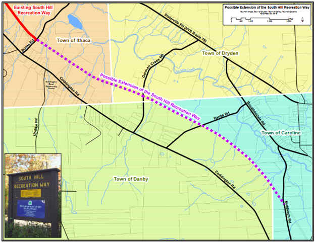
Note;
Plans are underway in 2024, to extend the South Hill Recreation Way,
Southeast,
another 3 miles to Middaugh Rd in Caroline.
Further plans will extend the trail another 5 miles
to the Tioga County border. See;
EXTENSION
PROJECT . See; Map Below.
The steep, paved South Hill Recreation Way
takes you down to the old rail bed where you'll find a Map Board and informational signs.
This heavily forested crushed gravel trail travels Northwest,
alongside a ridgeline with
some steep drop offs. Very scenic. Gorge-like. Mile Markers every 0.5
miles. Trail
turns to stone-dust after 1.5 miles and becomes more open. Pass by a Map Board
on your right and the small Juniper Drive parking area on your left
before coming to an intersection at Vincenzo Iacovelli Park at 1.7 miles. Here
the South Hill Recreation Way
splits.
Note; The paved Connector
Trail to your right leads Northeast,
down to the parallel Lower Trail. I Looped
back to here along this trail.
The Upper Trail now travels
Northwest, along a more
residential corridor. Pass a Map Board and come to Hudson St and the end of the
trail after 2.3
miles.
Note; Across Hudson St a paved
Trail zig zags 0.3
miles South, up to Ithaca College.
Note; To
Loop back to the Upper Trail via
the Lower Trail turn right and
travel on-road (sidewalk available) North,
downhill along Hudson St.
Pick up the Lower Trail at 2.8 miles on your
right at the sign. Map Board located here. The wide crushed
gravel Lower Trail travels Southeast,
up a slight hill along the ridgeline and travels through the woods. After 3.6 miles you reach the Connector
Trail. This paved trail zigzags South,
up past the playground and picnic pavilion
at Vincenzo Iacovelli Park, before returning you to the Upper
Trail at 3.9 miles. Head left,
Southeast, to return back to the Burns Road
parking lot for
a 5.7 mile Loop.
HH
CLICK HERE FOR
ITHACA TRAILS MAP
BEFORE YOU SET OUT BE
SURE TO READ THE
WAIVER
OF RESPONSIBILITY AND DISCLAIMER
BIKE IT OR HIKE IT
HOME
PAGE