DELAWARE & LEHIGH TRAIL;
BRISTOL-MT TOP, PENNSYLVANIA
-BIKE IT OR HIKE IT-
Last Updated: May 30, 2026
Length: D&L Trail; Delaware Canal Trail; Bristol-Easton Section [Southern End]; 60 miles
D&L Trail; Southern Lehigh Canal; Easton-Allentown Section [Southern Section]; 16.4 miles
D&L Trail; Central Lehigh Canal; Allentown-Northampton-Jim Thorpe Section [Central Section]; 30.7 miles
D&L Trail; Lehigh Gap & Gorge; Jim Thorpe-White Haven Section: [Northern Section]; 24.5 miles
D&L Trail; Black Diamond; White Haven-Mt Top Section: [Northern End]; 10.7 miles
D&L Trail; Black Diamond; Mt Top-Laurel Run Section; [Northern End]; 1.2 miles (4.7 mile section under construction in 2026)
Difficulty: D&L Trail; Delaware Canal Trail; Bristol-Easton Section [Southern End]; Easy. Flat crushed gravel Towpath.
D&L Trail; Southern Lehigh Canal; Easton-Allentown Section [Southern Section]; Easy. Flat paved & crushed gravel Towpath.
D&L Trail; Central Lehigh Canal; Allentown-Northampton- Jim Thorpe Section [Central Section]; Easy. Flat paved & crushed gravel Towpath and Rail Trail. Some on-road sections.
D&L Trail; Lehigh Gap & Gorge; Jim Thorpe-White Haven Section: [Northern Section]; Easy. Crushed gravel rail trail with a slight grade from White Haven to Jim Thorpe.
D&L Trail; Black Diamond; White Haven-Mt Top Section: [Northern End]; Crushed gravel trail.
D&L Trail; Black Diamond; Mt Top-Laurel Run Section; Easy. Unknown surface.
Directions:
D&L Trail; Delaware Canal Trail Section:
To start from Bristol Lions Park in Bristol [Southern End]; From I-95 take exit 42 to Route 13 south. After 1.5 miles come to Bath St and turn left. Follow to Mill St and follow south to Basin St and turn right. Follow straight to the parking lot and trailhead.
To start from Washington Crossing Gateway Heritage Park in Washington Crossing [Central Section]; From I-95 take exit 51to Taylorsville Rd and travel north. Turn right on Washington Cross Rd (Route 532) and the parking area will be on your left next to the canal. If you continue along Washington Cross Rd you'll come to River Rd (Route 32) just before the river. Turn left to visit Washington Crossing Historic Park.
To start from the Northern Terminus; Delaware Canal Trail parking lot in Easton [Northern End]; From the junction of Routes 22 & 611 in Easton follow Route 611 south. Cross the Lehigh River and turn left. You will quickly come to the parking lot on your left.
D&L Trail; Southern Lehigh Canal; Easton-Allentown Section:
To start from the Northern Terminus; Delaware Canal Trail parking lot in Easton [Eastern End]; See Above.
To start from Lehigh Canal Park in Allentown [Western End]; From I-78 take exit 57 to Lehigh St north. Cross the Little Lehigh River and turn right on Martin Luther King Jr Drive. Turn right on Union St and cross over the Lehigh River. Turn left on Albert St and follow around heading south along the RR tracks. Turn right on E Walnut St and cross over the RR tracks. Travel alongside the old D&L Canal, cross underneath a RR bridge and turn right into Lehigh Canal Park. Make an immediate left to reach the trailhead parking lot.
D&L Trail; Central Lehigh Canal; Allentown-Jim Thorpe Section:
To start from Lehigh Canal Park in Allentown [Southern End]; See Above.
Starting from Northampton & Cementon; Whitehall [Central Section]; From the junction of Routes 145 and 329 in Cementon; Whitehall travel East along Route 329 (Main St). Just before the Woodward Bridge over the Lehigh River, turn left on Railroad Street and follow to the parking lot at the end. If you continue East across the Woodward Bridge to Northampton and take your first right on Canal St, you'll find the Canal Street parking lot on your right.
To start from Jim Thorpe [Northern End]; From I-476 take exit 74 to Route 209 south. After you enter Jim Thorpe look right for the parking lot (parking fee). Enter and turn left to the end of the parking lot. For free parking continue on Route 209 and turn right over the River St bridge, then left on Front St/Main St. Turn left for Lehigh Gorge SP. You'll come alongside the trail where you'll find multiple parking areas.
D&L Trail; Lehigh Gap & Gorge; Jim Thorpe-White Haven Section:
To start from Jim Thorpe [Southern End]; See Above.
To start from White Haven [Northern End]; From I-80 take Exit 273 to Route 940 east. Travel 0.3 miles and turn right on Berwick St (Route 940). Cross main St and turn right into the White Haven Shopping Center. Go through the shopping center parking lot and bear left. Here you'll find POCONO BIKING and the shuttle drop-off spot. Continue straight for the D&L State Park parking lot.
D&L Trail; White Haven-Mountain Top Section:
To start from White Haven [Southern End]; From I-80 take Exit 273 to Route 940 east. Travel 0.3 miles and turn right on Berwick St (Route 940). Take your 4th left on Main St and follow to parking lot.
To start from the Woodlawn Ave parking lot in Mountain Top [Northern End]; From I-80 take Exit 273 to Route 940 east. Travel through town and continue straight to Route 437 north. Travel 7 miles. Parking lot will be on your right.
To start from the Lehigh Street parking area in Mountain Top [Northern End]; From I-80 take Exit 273 to Route 940 east. Travel through town and continue straight to Route 437 north. Travel 11.5 miles and turn right on Lehigh St. Parking area on right.
The Delaware & Lehigh National Heritage Corridor preserves, interprets and leverages the nationally significant history of the over 165-mile transportation route between Bristol and Wilkes-Barre, following the route that anthracite coal took from mine to market. It winds through northern mountains and along the banks of the Lehigh and Delaware Rivers through Northeast Pennsylvania, the Lehigh Valley and through Bucks County. The D&L Trail passes through towns, industrial powerhouses and along remnants of the Lehigh & Delaware Canals. Some sections of the trail run along the old Towpaths and other sections travel along old rail trails. The trail has lots of informational signs, Wayfinding signs and Mile Markers. The plan is to create a continuous trail. For more information visit; D&L NATIONAL HERITAGE CORRIDOR & RAILS to TRAILS; D&L TRAIL & LEHIGH GORGE SP .
D&L Trail; Delaware Canal Trail Section:
[Southern End]
Delaware Canal State Park Segment; The Delaware Canal Trail, which is part of the D&L Trail, travels North, from Bristol to Trenton, then turns Northwest, to Easton. This follows the linear Delaware Canal State Park for 60 miles. This is the longest section of trail, with only minor interruptions.
Along the New Jersey side of the Delaware River travels the Feeder Canal, part of the Delaware & Raritan Canal. There are many bridge crossings bikes can utilize to create a Loop along both sides of the river. See; Loop Map below. The Main Canal of the DELAWARE & RARITAN CANAL runs Northeast, from Trenton to New Brunswick. See; D&R Canal for bike trail information. For more information visit; DELAWARE CANAL & DELAWARE & LEHIGH CORRIDOR .
Inspired by the tremendous success of New York State's Erie Canal, the Commonwealth of Pennsylvania began building a 1,200-mile system of Canals to connect Philadelphia, Pittsburgh, and Lake Erie. These new transportation routes would carry the raw materials and manufactured products that would power this country's industrial revolution. The 60 mile long Delaware Canal is part of this great network. Completed in 1832, it runs from Bristol to Easton, where it connects with the Lehigh Canal. The primary purpose of these two waterways was to transport anthracite coal from the Northeastern Pennsylvania coal regions, to the cities on the eastern seaboard. Over its course of 60 miles, the Delaware Canal drops 165 feet through some 23 Locks. Ten aqueducts carry the waterway over small valleys and streams. Including its Towpath and berm bank, the Canal is approximately 60 feet wide and originally was five feet deep. As railroads began to seriously compete for freight contracts, Canal-generated revenues to the Commonwealth dropped. In 1858, the decision was made to sell the Delaware Canal to private operators. From 1866 to 1931, the Delaware Canal was run by the Lehigh Coal & Navigation Company, which also owned of the Lehigh Canal. Canal traffic and revenue declined until the "iron horse" finally beat the mule, when the last paying boat locked through in October 17, 1931. The significance of the Delaware Canal was recognized in 1978, when it was designated a National Historic Landmark. It is preserved today as the most intact and fully watered of America's Towpath Canals. For more information visit; DELAWARE CANAL TOWPATH .
I haven't checked out this Section. The D&L Trail starts from the Bristol Lions Park parking lot, next to the Delaware River. Informational signs all along the trail. Porto-Potty's. The paved Delaware Canal Trail/Bristol Spurline Park Trail travels from the parking lot to a circle, overlooking the Delaware River. Brown Delaware Canal Trail signs mark the route. The trail travels Northwest, between the parking lot and Bristol Marsh. Cross Canal End Rd and follow the brick trail Northeast, crossing Mill St, then left over *Old Route 13 at 0.4 miles.
Note; The Bristol Spurline Park Trail splits from the Delaware Canal Trail here. You may utilize the Bristol Spurline Park Trail to bypass the next section of the Delaware Canal Trail that has a 0.3 mile on-road section.
Bristol Spurline Park Trail:
Note; Straight, Northeast, the paved Bristol Spurline Park Trail [Continuing Mileage] continues alongside Old Route 13/Pond St. Trail then pulls away from the road heading through an urban corridor. Several street crossings before you cross Jefferson St, before coming to an intersection at 1.2 miles.
Note; Left, Northwest, will bring you to **Jefferson Ave & the Delaware Canal Towpath after 1.3 miles and back to the Delaware Canal Trail. See Below.
Continue straight, past a community garden, sports court, track, sports fields and playground before coming alongside some RR tracks. Cross Trenton Ave after 2 miles as the trail turns Southeast. Residential corridor with a couple of street crossings. Come to Radcliff St after 2.5 miles and the end of the trail. Part of this trail follows the old rail bed of the Philadelphia & Trenton Railroad and some of the former Canal Towpath.
Delaware Canal Trail:
From *Old Route 13 travel left, North, through a small parking lot where the paved Delaware Canal Trail [Continuing Mileage] travels through an open area (Delaware Canal is buried along here). Continue along the stone-dust trail and you'll pass by the remnants of Lock 2 or 3? The trail then follows a gravel road out to Buckley St at 0.7 miles. Head right, Northeast, on-road, to Beaver St and head right. You'll pick up the stone-dust trail on your left at 1 mile, as it travels through a residential corridor to Washington St. Across the street the narrow, stone-dust Delaware Canal Towpath continues along the Southern Side of the Canal (across which is Grundy Commons Park) to **Jefferson Ave at 1.4 miles.
Note; A paved trail in Grundy Commons Park, also follows the old Delaware Canal Towpath along the Northern Side of the Canal to **Jefferson Ave.
Cross **Jefferson Ave to Delaware Canal SP; Lagoon Park.
Note; On the Northern Side of the Canal, a paved trail takes you across the Canal Lagoon to a small island, where you'll find a gazebo.
Note; Right, East, a paved trail brings you back to the Bristol Spurline Park Trail. See Above.
The wide, stone-dust Delaware Canal Towpath continues North, along the Eastern Side of the Canal. Travel through Tullytown & Penn Valley, before coming to a tunnel underneath E Trenton Ave in Morrisville at 11.2 miles. Map Board & restrooms located here. Informational signs located all along the Canal.
Note; If you head right, past the restrooms to N Delmorr Ave and turn left, you'll come to E Trenton Ave. Right, Northeast, you can cross the Delaware River Bridge to Trenton, NJ. Here you can access the D&R Canal .
Continuing Northwest, [I've checked out this next section] the stone-dust Delaware Canal Towpath travels underneath E Trenton Ave along the Eastern Side of the Canal. You can briefly spot the Delaware River, to your right, across N Delmorr Ave, before the Canal turns inland. Cross by the E Ferry Road parking lot as the trail becomes more isolated. You’ll pass by a bench with an informative signboard on “Wide Water”, where the Canal widens. Come to the Black Rock Road parking lot at 13.2 miles where you’ll find some picnic tables. Just before you travel underneath a RR bridge at 14.3 miles, you'll pass by a Spur Trail on your right.
Note; This Spur Trail leads to Macclesfield Park, where you'll find a parking lot, restrooms, picnic tables and sports fields.
Pass by Lock 5 (Yardley Lock) as you enter Yardley, before you travel underneath Letchworth Ave. Residential corridor. Travel underneath a couple more bridges before you cross over Buck Creek. Here you follow a ¼ mile on-road (residential) section at 15 miles. Leave the town behind and pass by a wood pedestrian bridge over the Canal, followed by a red bridge over the Canal. You then pass by Lock 6 (Lear’s Lock) followed by a sluiceway before traveling underneath I-93 and coming to Woodside Rd at 16.2 miles.
Note; On your right, a paved trail leads up to a pathway that takes you East, across Scudder Falls Bridge (I-93) and over the Delaware River.
Note; On your left, a pedestrian bridge over the Canal leads to a paved trail that takes you West, past the 1799 House, to a Park & Ride parking lot. From here, you can access the paved Woodside Road Trail, which travels West, along the Northern Side of the road. Come to Merrick Rd, where the trail now continues along the Southern Side of the road. Come to Lindenhurst Rd after 2.2 miles. Here, the paved Lindenhurst Road Trail travels right, North, alongside the road, to Washington Crossing Road after 0.8 miles.
Continuing North, you immediately pass by a Canal Gate. Pass by Lock 7 (Borden’s Lock), Map Board & possibly an old Canal Tenders House at 16.5 miles. A Porto-Potty is located down the drive. Next you'll pass by a sluiceway at Dryers Creek, before traveling underneath Mt Eyre Rd. Travel underneath a couple of red bridges, before open fields along your right, before you cross a Canal Aqueduct over Houghs Creek at 18 miles. Travel underneath a red bridge, then underneath a 2nd red bridge, underneath GW Memorial Blvd at 18.9 miles.
Note; If you head right, East, along a paved Spur Trail, it leads to the Washington Crossing Gateway Heritage Park parking lot.
Note; If you continue East, along the Northern Side of GW Memorial Blvd (narrow paved trail), you'll quickly cross this road and continue East, along the Southern Side of the road. The narrow trail soon turns to brick. Just before a bridge over the river, you'll come to a wide paved trail that crosses the road after 0.4 miles.
Note; Right, South, this trail takes you through the Southern Side of the Lower Section of the park and quickly ends after 0.2 miles.
Note; Left, North, this trail takes you through the Northern Side of the Lower Section of the park, past the NPS Visitor Center, to River Rd after 0.3 miles. For more information See; WASHINGTON CROSSING HISTORIC PARK & PARK MAP .
I haven't checked out this next section. The wide, stone-dust Delaware Canal Towpath continues North, passing by the Upper Section of the WASHINGTON CROSSING HISTORIC PARK at 23.1 miles. It continues through New Hope, Lumberville, Point Pleasant, Upper Black Eddy, Kintnersville, Riegelsville before coming to Easton. You'll travel underneath 3 RR bridges before coming to the end of the Delaware Canal and the final Lock. A dam on your right separates the Delaware River from the Lehigh River on your left. Cross a bridge over the Canal to the Northern Terminus; Delaware Canal Trail parking lot after 60 miles. This is the start of the D&L Trail; Lehigh Canal; Easton-Allentown Section. See Below.
D&L Trail; Southern Lehigh Canal; Easton-Allentown Section:
[Southern Section]
The Lehigh Coal Mine Company was founded in 1792, a few months after anthracite coal was discovered. The coal was then transported down to Mauch Chunk (present day Jim Thorpe). The Lehigh Canal begins at the mouth of Nesquehoning Creek on the Lehigh River. It was built in 2 Sections over a span of 20 years beginning in 1818. The Lower Lehigh Canal traveled from Jim Thorpe (originally called Mauch Chunk) South, to Easton, using 44 Locks. In Easton, the Lehigh Canal met the Delaware Canal, which continued South, to Bristol. The Upper Lehigh Canal was built from 1837 to 1843. This section of the Lehigh River was a turbulent river with steep sides; a large portion was in a ravine, the Lehigh Gorge. The Canal rose over 600 feet in elevation to the Mauch Chunk slack-water pool. Unlike the Lower Lehigh Canal, where most Locks lifted less than 6 feet in easy stages, the Upper Lehigh Canal design relied on deep-lift Locks. The maximum lift on the Lower Lehigh Canal was less than 20 feet, but the Upper Lehigh Canal Locks lifted a maximum of 58 feet and had 29 Locks.
Starting from the Northern Terminus; Delaware Canal Trail parking lot in Easton; This is the start of the D&L Trail that travels from Easton West, through Bethlehem to Allentown. I haven't checked out this section. [Re-zeroing Mileage] The paved D&L Trail travels West, between the Lehigh River and Route 611. Travel underneath the Route 611 bridge at 0.3 miles. The trail then travels between the RR tracks and Lehigh River. The old Lehigh Canal and Locks 48 & 49 were buried by the RR through here. Lock 49 was the final Lock out to the river, however, when the Lehigh Valley RR was built a new Lock was built out to the river. Travel past the replacement Lock that leads to the river, as you pick up the old Canal. Next, travel underneath a RR bridge and cross Lock 47 over the Canal to the old Lehigh Canal Towpath at 1 mile. From here the trail splits. You can continue left, along the Northern Side of the Lehigh Canal Towpath or head straight along the Lehigh River. Both paved trails turn South and merge at 1.5 miles, where the Towpath travels between the river and Canal and RR tracks follow along the Southern Side of the Canal. The trail then pulls away from the Canal, passing by Easton Bicycle Skills Park, where a BIKE LANE takes you out to Hill Rd at 2.4 miles.
Note; Across Hill Rd is the entrance for Hugh Moore Park and parking lot. With more than 2 miles of restored Lehigh Canal, a Canal Boat attraction (rides on the 110-passenger Josiah White II Canal Boat (June-October) and one of the country’s largest Canal Heritage Museums, the 520-acre park is nestled between the Lehigh Canal and Lehigh River. Also in the park, a playground, Dog Park and Welcome Center (June-October) where you can rent bikes, canoes, paddleboats, and kayaks. A 1 mile section of the Lehigh Canal Towpath travels South, through the park. After passing by the Lehigh River Chain Dam you'll come to the old Locktender's House and old Lock. No outlet.
Continue right, West, across the Lehigh River (narrow path) and across Lehigh Dr, where the paved D&L Trail continues South along a ridge, utilizing a former RR bed. As you travel underneath the S 25th St bridge you enter Palmer Township. This is the start of the Palmer Township Bike Path, which is utilized by the D&L Trail. Cross Lehigh Dr into the Riverview Park parking lot at 2.9 miles. You'll come to a gate and Map Board next to a 2nd parking lot. Here the trail splits. The Palmer Township Bike Path is part of both trails. The D&L Trail continues straight through the park before entering the woods.
Note; The other section of the Palmer Township Bike Path travels left, through the 2nd parking lot, then left again, South, alongside the Lehigh River. Looks more scenic. It brings you to the Lehigh River Chain Dam and Fish Ladder at 0.4 miles, where a tunnel takes you underneath the D&L Trail (I'm not sure if both trails connect here) and up to Chain Dam Rd at 0.6 miles, where it continues Southwest, on-road. See; Map Below.
Come to the Lehigh River Chain Dam and Fish Ladder at 3.4 miles.
Note; The Palmer Township Bike Path travels underneath the trail here (I'm not sure if both trails connect).
The Lehigh River splits here. The trail turns Southwest, along what I assume was the section of river used by the Canal. Come to an intersection at 4.7 miles.
Note; The Palmer Township Bike Path continues right. See; Map Below.
Continue straight and you'll pass through the Hope Road parking lot. The trail then zig zags down past the Route 33 Boat Launch and back into the woods at 5.2 miles.
Note; This next section was hard packed dirt & gravel and is rough, as of 2021. I would bypass this section, by following the gravel access road West, which parallels the trail. Travel underneath Route 33 before coming to an intersection. Head left, through a tunnel and you'll rejoin the Lehigh Canal Towpath after 0.8 miles next to the *Bethlehem Boating Club.
Heading into the woods, you'll soon come alongside the Lehigh Canal, where it connects to the river. This section consisted of hard packed dirt and gravel, as of 2021 and is rough in spots. Next, you travel underneath Route 33 before coming to an intersection, next to the *Bethlehem Boating Club at 5.8 miles. The stone-dust Lehigh Canal Towpath continues between the river and Canal, although I believe the Canal is mostly dry. At 6.7 miles pass by Lock 45, where the Canal exited the river, along with some benches. The trail widens past here. Pass by Trail Spur at 7.2 miles.
Note; This Trail Spur leads to Farmersville Rd.
Pass by another Trail Spur at 8.4 miles.
Note; This Trail Spur leads to the Wilson Ave parking lot at Nagy's Landing.
Again, the old Canal is mostly dry. Come to Old Freemansburg where you'll find Lock 44, an old Mule Barn, Locktender's House and the FREEMANSBURG CANAL EDUCATION CENTER . Past here, the Lehigh Canal Towpath follows a full Canal as it travels South, next to the river along your left. Residential Freemansburg is across the Canal. Come to a bridge over the Canal at 9.2 miles.
Note; This bridge takes you over to Main St.
Travel underneath the Freemansburg Bridge, after which the trail turns West. Travel underneath the Minsi Trail Bridge in Bethlehem at 10.9 miles. If you look across the river you'll spot the smokestacks from the old Bethlehem Steel Plant. Come to Bridge 1 on your left at 11.6 miles. I've checked out this next section.
Note; Bridge 1 takes you over Monocacy Creek to Sand Island.
Continuing along the Lehigh Canal Towpath, you'll travel underneath the Fahy Bridge before coming to Bridge 2 on your left.
Note; Straight is where the Lehigh Canal Aqueduct crossed over Monocacy Creek. Lock 42 here. Dead end.
You'll need to cross Bridge 2 over Monocacy Creek to Sand Island at 12 miles.
Note; Left, East, the stone-dust Sand Island Trail travels through Sand Island, past sports courts and a parking lot. Come to the Eastern End of the Island where you'll find Bridge 1 on your left that will return you to the Lehigh Canal Towpath after 0.4 miles.
Heading right, West, the stone-dust Sand Island Trail & Lehigh Canal Towpath travels past a playground, picnic tables and the Ice House, where it follows the Canal to Main St.
Note; You can access the South Bethlehem Greenway & Colonial Industrial Quarter on-road from here. Turn right, North, on Main St and cross the Canal and RR tracks. Travel past the old Historical Bethlehem Central Railroad of New Jersey Station & Freight House) on your right to W Lehigh Street.
Note; To check out the Colonial Industrial Quarter, continue along Main St to Spring St. Cross the road and travel through the Spring Street parking lot. I haven't checked out this area. Travel underneath the off-ramp and turn right across the Waterworks Pedestrian Bridge, which crosses Monocacy Creek. Here a paved Trail travels North, past the Bethlehem Waterworks, Historical Tannery, Dye House and other old structures.
Note; Head right, East, on-road along W Lehigh Street to the Fahy Bridge. Head right, South, along a separated path, over the Lehigh River and W 2nd St to and across W 3rd St to S New St. Just up this street you'll come to the South Bethlehem Greenway after 0.8 miles
Continue across Main St and travel underneath the Hill to Hill Bridge and a RR bridge before passing by a BIKE STATION. You then exit Sand Island at 12.5 miles and continue along a causeway between the Canal and Lehigh River. Isolated. Pass by old Lock 41 at 13.5 miles, where the trail starts to Loop Southwest, as you cross into Allentown. RR tracks follow across the Canal and soon lead to a large freight yard. Pass by the Lehigh Canal Park parking lot and Boat House before coming to the park entrance road.
Note; Left will take you up to Lehigh Canal Park and more parking. A short trail will take you alongside the Lehigh River to a canoe launch and picnic pavilion.
Right, you'll cross over the Canal to Lock 40, next to E Walnut & S Albert Streets at 16.4 miles.
D&L Trail; Central Lehigh Canal; Allentown-Northampton-Jim Thorpe Section:
[Central Section]
Starting from Lehigh Canal Park in Allentown [Southern End]; [Re-zeroing Mileage] I haven't checked out this section. Exit the park, crossing the Canal to Lock 40, next to E Walnut & S Albert Streets. The hard packed dirt & grass D&L Trail travels left, North, along the Southern Side of the Canal.
Note; You can also travel on-road, along S Albert Street (low traffic).
Travel underneath a RR bridge and across a Sluiceway. Come to a pedestrian bridge over the Canal, that will take you out to S Albert Street and continue left, on-road (low traffic). Cross over the RR tracks and travel underneath E Hamilton St. To your left, across the RR tracks is the Hamilton Dam, where the Canal connects to the Lehigh River. You'll then pick up the D&L Trail on your left at 0.7 miles. The Lehigh Canal utilized the Lehigh River past here. This paved section travels North, through the woods. As you come alongside the RR tracks the trail ends at N Bradford St after 1.2 miles. Continue left, on-road (low traffic), to N Dauphin St and continue left, on-road (wide shoulder). Travel underneath the American Pkwy bridge and come to the Kimmett's Lock parking lot at 2 miles.
Note; To your left, is a boat ramp. This was where Lock 39 (Kimmett's Lock) was located until it was destroyed by the Flood of 1942.
Note; I believe the hard packed dirt & grass Lehigh Canal Towpath starts at the Northern End of the parking lot, following the old Canal, although if so it dead ends.
Instead, you'll need to travel on-road, North, along N Dauphin St (wide shoulder), to Hanover Canal Park parking lot at 3 miles. Restrooms & picnic pavilion. Travel left, South, through the parking lot, then right past the large picnic pavilion-small pavilion and 2nd small pavilion. Here you'll find a Map Board and Lock 37. The hard packed dirt & grass Lehigh Canal Towpath continues North, past Catasauqua Lake, then I believe crosses the Canal and connects to a stone-dust trail.
Note; This trail travels right, South, back along Catasauqua Lake, passing a dock overlooking the lake and returning you to the parking lot after a 0.6 mile Loop.
The Lehigh Canal Towpath continues North, through Catasauqua to Catasauqua Creek.
Note; Construction of a bridge over this creek was underway in 2024 and will continue the trail out to Race St.
Travel right, out to Lehigh St and head left, on-road (no shoulder) a short distance to Race St. Check out all the stone buildings. Travel left across the bridge. Just before the RR tracks, turn right and spot a D&L Trail sign at 3.7 miles. A path will take you down to the stone-dust Lehigh Canal Towpath which travels North, alongside the Canal. Quickly pass by a bridge over the Canal, which leads to the Deily Coal Yard parking lot. Picnic tables here and an "Old Company Lehigh Coal "building. This section travels between the Canal and RR tracks, traveling underneath the Pine St bridge, crossing into North Catasauqua and traveling underneath a RR bridge. After traveling underneath the Lehigh St bridge, this is where the Canal connected to the Lehigh River. Not sure if there is a Lock here. The D&L Trail now travels between the river and RR tracks. Come to a tunnel underneath the RR tracks on your right at 5.2 miles.
Note; If you travel through this tunnel, a paved trail takes you to the North Catasauqua Public Works parking lot.
The D&L Trail continues North, between the river and RR tracks, crossing into Northampton. Cross a bridge over Dry Run at 5.7 miles, before traveling under a RR bridge, followed by the Chestnut St Bridge and crossing another bridge over Hokendauqua Creek, bringing you to the Canal Street parking lot at about 6.1 miles.
Note; If you travel right, out of the parking lot, on-road along Canal St, then left, along W 10th St, you'll come to Main St after 0.2 miles. Here you can access the paved Nor Bath Trail . If you continue right, on-road along Main St to E 9th St. Turn right, across the Lehigh River to N Front St in Coplay. Head left to Ridge St. Down this road will bring you to the Ironton Rail Trail .
The now paved D&L Trail continues North, between the river and Canal St, passing by Canal Street Park (ball fields, sports fields, playground and parking lot). Come to the Canal Street parking lot after 7.3 miles.
Note; The trail then continues underneath the Woodward Bridge (Route 329) where the wide, stone-dust Lehigh Canal Towpath continues alongside the Canal. Cross an un-named road after 0.4 miles, next to the Tri-Boro Sportsmen Club. The trail continues as hard packed dirt & grass, although I'm not sure how far.
The D&L Trail continues across the Lehigh River, so from the Canal Street parking lot you'll need to travel left, along Canal St to Route 329, then left, West, across the Woodward Bridge to Cementon; Whitehall. Immediately turn right to access the Railroad Street parking lot after 7.6 miles. The stone-dust D&L Trail travels North, along the former Lehigh Valley RR bed. Map Board. Lehigh River is along your right and residential on your left. Pass by Riverwalk Park, where you'll find a playground, sports court & picnic tables. Past here, you leave the town behind and continue through woods. At 9.6 miles you pull away from the river as you approach Laurys Station. Cross River Dr before crossing over Fells Creek. The trail then Loops South, passing by the Cove Road parking lot at 11.6 miles. Map Board. You quickly pass the Treichlers Bridge Boat Launch parking lot before traveling underneath Route 145. The trail now travels closer to the river, passing by the location of the old Treichlers Dam. Across the river is where the Lehigh Canal connected to the Lehigh River. The trail turns Northwest and soon brings you to a sharp left (I believe briefly leaving the old rail bed to bypass residential), then right, North, inland. Trail turns West, back along the river, then North. Pass by the Shady Nook Road parking lot at 15.8 miles as you follow the river and skirt Slatington and Railroad St. You'll come to an intersection on your left.
Note; This is the Eastern End of the Slate Heritage Trail which travels West.
Continue straight past the Main Street parking lot, before coming to Main St at 17 miles. Map Board & restrooms.
Note; Another section of the Lehigh Canal Towpath can be accessed by traveling right, East, across the Lehigh River to Walnutport. The trail crosses Main St just after you cross the bridge.
Note; Heading right, South, down Lehigh St to the Walnutport Boat Launch. The hard packed dirt & grass Lehigh Canal Towpath follows the Lehigh Canal, quickly passing by Lock 23 and the Locktender's House. Picnic table. After 0.4 miles you leave the town behind. Across the Canal, RR tracks parallel the Canal. Pass by Lock 24 at 0.7 miles. You then come alongside the Lehigh River and some old bridge abutments. Pass by Lock 25 at 1.5 miles. Some stone remains of the old Locktender's House. After 2.1 miles come to remains of the old aqueduct at Bertsch Creek and Lock 26. I believe this is as far as you can go. Another 0.1 miles brings you to Lock 27, where the Canal connects to the Lehigh River.
Note; Heading left, North, the hard packed dirt & grass Lehigh Canal Towpath follows the Lehigh Canal past Earl F Snyder Park. Trail travels between the Canal and Lehigh River. Pass by a pedestrian bridge over the Canal that leads to the N Canal Street parking lot. Come to the end of the trail after 1.8 miles, where Lock 22 and the Canal connected to the Lehigh River.
Continuing North, along the stone-dust D&L Trail from Slatington, you'll continue along the former rail bed into the woods. Pass by the treatment plant, followed by the Slatington Airport, as you skirt the town. Head back into the woods again at 18.3 miles. Pass by the site of the old Lehigh Valley RR Station and Paint Mill Road parking lot at 18.9 miles. Quickly pass by the Lehigh Gap Boat Launch parking lot before traveling underneath the Route 873 bridge, where you briefly travel alongside Paint Mill Rd, passing by the Lehigh Gap Nature Center. The isolated trail now travels alongside the Lehigh River. At 20.4 miles the trail turns West. Pass by River Point Canine Park at 22 miles before the trail travels alongside Riverview Rd as it turns North. You then pass by the Riverview Park parking lot. The trail then crosses over Riverview Rd and continues paved, crossing over Lizard Creek, before crossing E Lizard Creek Rd (Route 895) and traveling down to Bowmans Road parking lot at 23.2 miles in West Bowmans. Picnic pavilion overlooking the Lehigh River. You then travel right, a short distance, along Bowmans Rd where you pick up the stone-dust D&L Trail. The trail continues North, along the river and below I-476, up on your left. Travel underneath I-476 at 24.5 miles, where the trail turns Northwest, continuing along the river. Travel past a treatment plant before coming to Lehigh Dr at 25.7 miles. Here you travel on-road (low traffic), crossing over Mahoning Creek and traveling underneath E Bridge St and Bridge St. On your left a paved trail takes you up to Bridge St in Lehighton at 26.4 miles. Head left, East, across Bridge St (BIKE LANE) over the Lehigh River to Railroad St in Weissport. Continue on-road (no shoulder, but only 0.2 miles) along Bridge St, crossing White St and some RR tracks. On your left is the Lehigh Canal Park parking lot at 26.8 miles. The Lehigh Canal Towpath crosses here and the D&L Trail continues North.
Note; Heading right, South, the Lehigh Canal Towpath only travels 1.4 miles before ending at Rock Hill Rd (industrial site road). I believe the Towpath is unimproved hard packed dirt & grass along this section, but am not sure. The trail travels underneath the E St bridge, before passing by Lock 9 (overgrown) at 0.6 miles, where you travel between the Canal & RR tracks and river. You then come to Lock 10 at 1.1 miles. The trail here looks like stone-dust. There is also an old stone cellar nearby, along with a Canal Flume, which took water around the Lock when the gates were closed, to prevent overflow. The Canal now travels under the RR tracks. Not sure if the trail crosses as well? Come to Rock Hill Rd. I'm not sure if this is a private road, as it travels through the Rock Hill Concrete site. This road then crosses the Canal and travels underneath I-476 before crossing the RR tracks out to Route 248. If you were to continue alongside the Canal you will come to Lock 13 where it connects to the Lehigh River and Pohopoco Creek after 1.9 miles.
Continuing North from Bridge St, the paved Lehigh Canal Towpath travels between the Lehigh Canal and Lehigh Canal Park parking lot. Picnic pavilion and Map Board. The stone-dust trail then continues alongside the Canal, quickly passing by Lock 8. You briefly travel between the Canal & Lehigh River, before following the Canal. Pass by Lock 7 at 27.8 miles, before following the river again. Somewhere you'll pass by Lock 6. Pass by Lock 5 at 29.3 miles. Here you'll find a bridge over this Lock that leads to an observation platform that overlooks this Lock, along with the stone remains of the old Locktender's House and a Canal Flume, which took water around the Lock when the gates were closed, to prevent overflow. The trail then travels underneath a RR bridge as it turns West. Pass by Lock 4 or 3 at 30.1 miles before the trail turns North, past a treatment plant. Here you travel up to the *Mansion House Pedestrian Bridge over the Lehigh River. This brings you to the Jim Thorpe parking lot in Jim Thorpe (formally Mauch Chunk) after 30.7 miles. This was the starting point of the Lower Lehigh Canal and the ending point of the Upper Lehigh Canal.
D&L Trail; Lehigh Gap & Gorge; Jim Thorpe-White Haven Section:
[Northern Section]
Unlike all the previous Sections, I start this section from the Northern End. That is because we utilized a Bike Shuttle from Jim Thorpe to White Haven. See; POCONO BIKING .
Starting from the Pocono Biking Center (At the Southern End of the White Haven Shopping Center) in White Haven [Northern End]; [Re-zeroing Mileage] I've checked out this section. A gravel road takes you South, from the Pocono Biking Center through the D&L State Park 1st & 2nd parking lots.
Note; I believe a new paved trail starts from the Southern End of Main St (On the West Side of the White Haven Shopping Center) and travels South, next to the RR tracks, before bringing you down to the D&L State Park 1st parking lot.
Travel underneath I-80, past a 3rd parking lot and underneath a RR trestle (I don't believe cars are allowed past here) before coming to the D&L State Park entrance road at 0.5 miles.
Note; Right, will bring you to a 4th parking lot and left leads to the White Haven boat launch.
Informational signs located along the trail. The crushed gravel D&L Trail travels across a small bridge over Linesville Creek and soon passes by Mile Marker 128. Mile Markers located every mile along the trail. The Lehigh River parallels the trail way below on your left. Well shaded trail. Cross Tannery Rd at 1.6 miles and pass by the Tannery Road parking lot. You travel along a ridge with tons of Rhododendrons. The trail turns East, then South. Cross an old double tracked RR bridge over Sandy Run at 3.9 miles. Soon you'll be able to spot a set of RR tracks across the river that travel from White Haven to Jim Thorpe. There are also signs located along the trail that let you know the distances between locations. Pass by an informational sign for Lock 22 of the former Upper Lehigh Canal at 5 miles.
Note; Hiking down the trail I didn't find any remnants of this Lock. However, you can access the river and spot a beautiful stone arched RR bridge across the river where Mud Run enters the river.
The trail turns West. Just past Mile Marker 120 after 9 miles you'll come to Buttermilk Falls and a bridge. Next you'll cross over Buck Mt Creek and come to the Rockport parking lot at 9.3 miles in Lehigh Gorge SP. [This is another Bike Shuttle drop-off for a shorter trip back to Jim Thorpe]. Restrooms located here. River level now. Pass Lukes Falls at 9.6 miles as the trail turns East. Just past the falls on your right is some sort of stone structure? Pass a small cascading waterfall at 10.8 miles. Pass a red mileage sign on your left at 11.7 miles as the trail turns South. Look across the river to spot another stone-arched RR bridge across Drakes Creek. At 13 miles find a sign for Stony Creek. Look left to spot a RR bridge across the river. Trail now turns West. Cross a RR bridge over Black Creek and come to some RR tracks at 16 miles as the trail turns South. Here is where the RR tracks from the opposite bank of the river cross over. This is called Penn Haven Junction where three railroads converged. Informational sign here.
Note; This is where the future Weatherly Borough-Delaware & Lehigh Trail connection will possibly come in from the West. This trail will travel West, along Black Creek, to Weatherly.
Travel between the tracks then left across one set. The trail now travels between the river and the RR tracks which become elevated. Pass by Bear Creek tributary at 18.6 miles. After 21.7 miles you share the road as you enter Glen Onoko. Parking lot located here along with a Porto-Potty, picnic tables and Map Board. A dirt path leads down to the river. Cross the wooden bridge over the river and look left to spot a tunnel opening in the side of the mountain above the river. That's the remnants of an old RR tunnel. The trail continues briefly on-road until you come to another parking lot on your left at 22 miles. I refer to this as the Tunnel parking lot as you can access the old RR tunnel from here. At the back of the stone-dust parking lot is the entrance to the tunnel.
Note; This is where you'll find a partially covered entrance for an old double tracked RR tunnel. If you walk through the tunnel it ends above the river where you can still see the old stone RR supports. Caution; the tunnel has an unsupported roof and you can see where rocks have fallen in the past. Pass at your own risk.
The trail picks up on your right traveling between the RR tracks and the road for a short distance before bearing right over a trestle bridge alongside the tracks at 22.5 miles. The trail turns Southeast, crossing over even more RR tracks. Pass by a dirt trail leading down to the Upper Lehigh Canal Lock 2 on your left. You can still make out some of the old Canal from the trail. Next you'll cross a bridge over the river where another set of tracks come in from your right. The trail now travels between the tracks and river. Pass by a rail yard full of old cabooses and rail cars at 23.6 miles. Come to a Map Board and the Jim Thorpe parking lot at 23.9 miles in Jim Thorpe. A SEPARATED BIKE PATH travels along the long parking lot. Come to the old RR Station, which is now a Visitor Center, at 24.3 miles. If you continue through the parking lot it will bring you to the *Mansion House Pedestrian Bridge after 24.5 miles.
Note; Across the street from the Visitor Center is the POCONO BIKING center. Here you can take a Bike Shuttle North, to White Haven and ride your bike (or bike rental) South, back to Jim Thorpe. Be sure to check out the historic town of Jim Thorpe, which was formerly known as Mauch Chunk, a Leni Lenape Indian name which means "Bear Mountain." The steep hillsides, narrow streets, and terraced gardens earned Mauch Chunk the nickname “The Switzerland of America.” The formation of the Lehigh Valley Railroad in the 1850s brought prosperity to the area as it carried anthracite coal and other goods to market and promoted Mauch Chunk as an excursion destination. In the 1870s, competition came with the arrival of the Central Railroad of New Jersey and a second mainline that paralleled the LVRR through the region. The recently renovated former Central Railroad of New Jersey Station is now a Visitor Center & museum (restrooms). Next to the old RR station is the ticket office for the LEHIGH GORGE SCENIC RAILWAY which offers 16 mile round trip excursions through Lehigh Gorge. You'll also want to check out the “Old Mauch Chunk Historic District.” Many buildings are now listed on the National Register of Historic Places. Travel West, up Race St (across from the Visitor Center) then Loop back, East, down Broadway.
Note; The SWITCHBACK RAILROAD TRAIL travels from Summit Hill West, to Jim Thorpe along the old SWITCHBACK GRAVITY RR . haven't checked out this trail.
D&L Trail; Black Diamond; White Haven-Mt Top Section:
[Northern End]
Starting from the Southern End of Main Street in White Haven [Southern End]; [Re-zeroing Mileage] I haven't checked out this section.
Note; The Pocono Biking Center is located at the Southern End of the White Haven Shopping Center, which is just East, of Main St.
Travel North, on-road, along Main St. Look right to spot an old red Union Pacific RR Caboose located in the White Haven Shopping Center, before crossing Berwick St. Continue along Main St and you'll come to the Lehigh Gorge SP parking lot at 0.3 miles.
Note; Picnic tables & TRAIL TOWN BIKES bike rentals located here.
The crushed gravel D&L Trail (also known as the Black Diamond Trail) continues North, into the woods, traveling alongside the RR tracks. Cross Middleburg Rd, then the RR tracks as the trail briefly heads left, along the road at 2 miles, before turning right, Northwest, back into the woods. Trail soon turns North. Cross the RR tracks (bridge?) at 3.4 miles. Cross Webster & Webster Rd at 5.5 miles. The trail then travels past Creasy Creek, before turning West, past Moosehead Lake. The trail ends after 10.7 miles at the Woodlawn Ave parking lot in Mountain Top.
Note; There’s about a 4-mile Gap from this trailhead North, to the isolated last section of the D&L Trail in Mountain Top.
D&L Trail; Black Diamond; Mountain Top-Laurel Run Section:
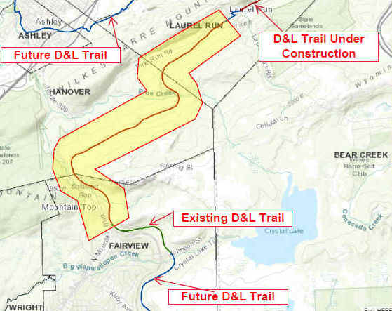
Starting from the Lehigh Street parking area in Mountain Top [Northern End]; [Re-zeroing Mileage] I haven't checked out this section. The D&L Trail (Not sure what the surface consists of?) travels South, then East, through the woods, along a ridgeline above Woodlawn Ave. It finally turns South, ending at Johnson St after 1.2 miles.
Note; A new section is under construction in 2026, that will extend the trail another 4.7 miles North, to Laurel Run (Oliver Mills), with completion set for Fall 2026. See; Map Below.
HH
CLICK HERE FOR DELAWARE CANAL SP TRAIL MAP 1
CLICK HERE FOR DELAWARE CANAL SP TRAIL MAP 2
CLICK HERE FOR DELAWARE CANAL/FEEDER CANAL LOOP TRAIL MAPS
CLICK HERE FOR PALMER TOWNSHIP BIKE PATH
BEFORE YOU SET OUT BE SURE TO READ THE
WAIVER OF RESPONSIBILITY AND DISCLAIMER
BIKE IT OR HIKE IT