CLIFTON PARK TRAILS:
CLIFTON PARK, NEW YORK
-BIKE IT OR HIKE IT-
Last Updated: August 25, 2025
Length: Clifton Park Center Loop Trail; 8.8 mile Loop
Moe Road Trail; 2.8 miles
Town Center Park-Moe Road-Balsam Way Trails; 3 miles
Difficulty: Clifton Park Center Loop Trail Loop; Easy. Flat paved trails w/some residential on-road sections.
Moe Road & Town Center Park Trails; Easy. Flat, wide paved trail.
Balsam Way Trail; Easy. Flat, narrow paved trail.
Directions:
Starting from Route 146 (Clifton Park Rd) along the Vischer Ferry Road Trail [Northern End]; From I-87 take exit 9W to Route 146 west. Travel about 2.3 miles and turn left on Vischer Ferry Rd, then right into the North County Commons where you may park.
Starting from the Town Center Parks; Maxwell Drive parking lot for the Town Center Park-Moe Road-Balsam Way Trails [Northeastern End]; From I-87 take exit 9W to Route 146 west. Travel less than 0.5 miles and turn left on Maxwell Dr. The park will be on your right.
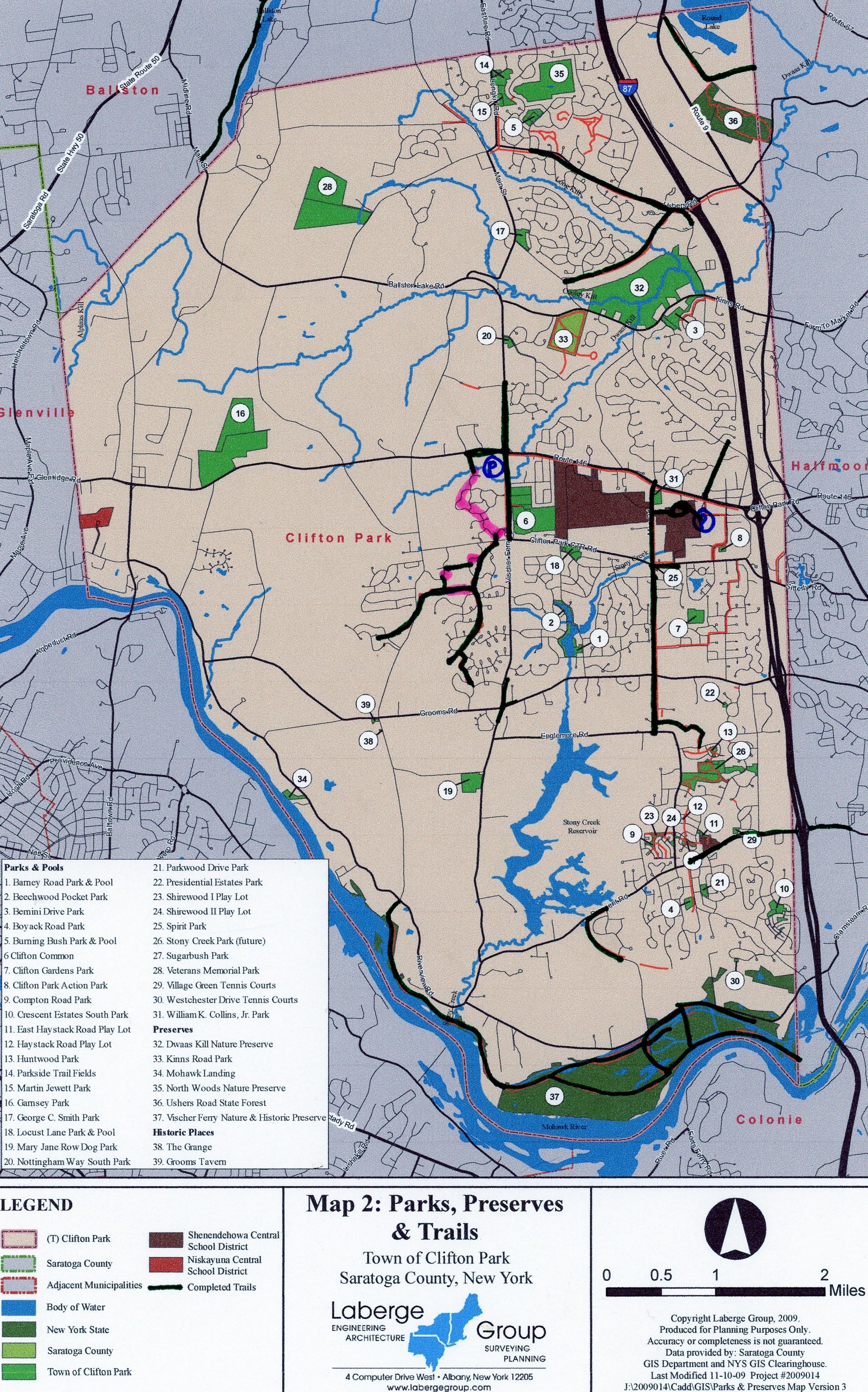
The Clifton Park Trails are a series of paved trails in Clifton Park that are linked together. Some trails travel alongside the road while others through neighborhoods, woodlands and meadows. The Clifton Park Center Trail and Clifton Park Loop both start from *Route 146 and head South. The Clifton Park Center Trail is almost all off road and connects to the Settlers Hill Trail, while the Clifton Park Loop Trail utilizes the Clifton Park Center Trail but includes on-road sections in order to Loop back to *Route 146. Although both trails start off using the same route, I describe them separately, so as not to cause confusion. See; CLIFTON PARK TRAILS for more information.
Clifton Park Center Loop Trail:
Starting from *Route 146 (Clifton Park Rd); The wide paved path travels South, alongside the Vischer Ferry Road Trail.
Note; The Vischer Ferry Road Trail also travels North, for 0.6 miles, to Dawson Ln.
Pass by the entrance to Clifton Common Park, across the road, at 0.5 miles. After 0.7 miles, just before the trail ends at Clifton Park Center Rd, take a right along Gloucester St and travel on-road for a short distance before spotting a wooden trail sign on your left and the start of the Neighborhood Path at 0.9 miles. Follow the narrow paved trail out to and across Clifton Park Center Rd. Mileage Markers are painted on the trail every 0.25 miles. The trail winds through open fields, low brush and woods between neighborhoods. When you reach Michelle Dr after 1.3 miles turn right then an immediate left to rejoin the trail. Next you'll come to Waverly Pl and a traffic circle at 1.5 miles.
Note; You may access the Settlers Hill Trail from here by turning right up Waverly Pl. See; Settlers Hill Trail Below. I backtracked to here, after finishing the Neighborhood Path.
Continue straight through the neighborhood, crossing Summerlin Dr and you'll soon enter some woods where the trail widens. You'll cross Avenue of the Oaks twice before spotting a sign reading "Dead End" at 2.3 miles.
Note; Heading straight into the woods this trail dead ends after only 0.2 miles.
Turn left alongside the road, then right back into the woods. After crossing 4 Leaf Manor the trail abruptly ends in the woods after 2.8 miles. I backtracked from here to Waverly Pl at 4.1 miles and connected to the Settlers Hill Trail.
Settlers Hill Trail:
From the Neighborhood Path where it crosses Waverly Pl, travel West, up Waverly Pl on-road (residential). [Continuing Mileage] Turn right on Fairhill Rd (residential) and you'll pick up the Settlers Hill Trail, on the right after 4.5 miles, by the 3 yellow poles. Follow the paved trail into the woods and you quickly come to an **Intersection at 4.6 miles. I backtracked to here.
Continue straight, West, up a slight hill passing by the water tower and then out to Miller Rd, where the trail heads left, South, alongside the road. After crossing Miller Rd the trail heads West, into the open scrub. After a slight descent the trail ends after 5.4 miles at Wallflower Dr. I backtracked from here to the **Intersection at 6.2 miles and headed left, North, up to Addison Way. Travel right, for a short on-road (residential) section, before heading right, East, back along the trail by a yellow pole. Come to Michelle Dr where you'll travel left, Northeast, on-road (residential) before returning to the Neighborhood Path as it crosses the road at 6.9 miles. Head left, North, along the Neighborhood Path back to Gloucester St. Travel left, North, on-road, along Gloucester St to Oakhurst Ct on your left and continue to a paved trail on your left at 8 miles. Follow this trail, crossing Dwaas Kill, to Chillmark Turn, then left out to Tisdale Ln. Head right and pick up the paved Route 146 Trail on your right. Follow this trail East, back to *Route 146 after a 8.8 mile Loop.
Town Center Park-Moe Road-Balsam Way Trails:
Starting from the Town Center Parks; Maxwell Drive parking lot; Map Board. The wide paved Town Center Park Trail travels West, through the park. Come to an intersection. Travel either way around an open field, as the trail Loops back together. Travel past the Town Center Parks; Moe Road parking lot out to Moe Rd at 0.5 miles.
Note; Heading right, North, the wide, paved Moe Road Trail travels 0.3 miles before ending at Route 146.
Travel left, South, along the wide, paved Moe Road Trail. Come to Carlson Way after 2.3 miles.
Note; The Moe Road Trail continues South, to Englemore/Moe Rd after 2.5 miles and ends.
Across Moe Rd, the narrow paved Balsam Way Trail travels South, from Carlson Way, before turning East, into the woods. It crosses Balsam Way and continues through the woods, turning South, to Huntwood Dr where it ends after 0.7 miles [3 miles].
HH
CLICK HERE FOR CLIFTON PARK TRAILS MAP
CLICK HERE FOR TOWN CENTER PARK-MOE ROAD-BALSAM WAY TRAILS MAP
BEFORE YOU SET OUT BE SURE TO READ THE
WAIVER OF RESPONSIBILITY AND DISCLAIMER
BIKE IT OR HIKE IT