BRONX RIVER GREENWAY:
BRONX-VALHALLA, NEW YORK
-BIKE IT OR HIKE IT-
Letterbox Planted: April 19, 2009
Last Updated: December 09, 2025
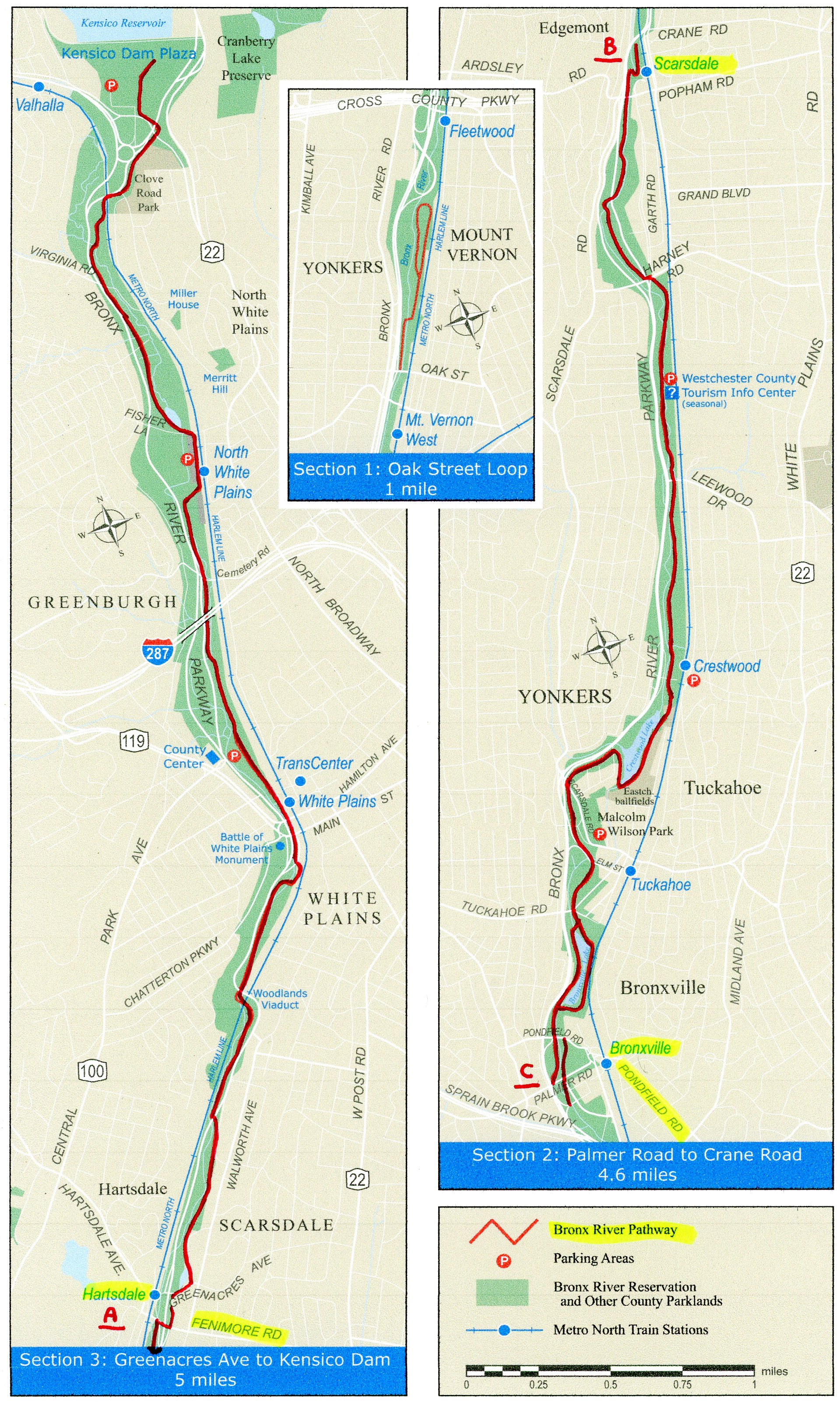
Length: Upper Bronx River Greenway; Northern Section; 13.4 miles.
Upper Bronx River Greenway; Southern Section; 1.3 miles
Lower Bronx River Greenway; 8.3 miles with some on-road detours.
Soundview Park Loop; 0.8 mile Loop.
Pugsley Creek/Castle Hill Parks Trail; 1.2 miles.
Shore Haven Bike Path/Clason Point Park Path; 1 mile.
Difficulty: Upper Bronx River Greenway; Moderate. Paved trail but a bit hilly in spots. Could be tough for kids on bikes.
Lower Bronx River Greenway; Moderate. Paved trail but a bit hilly in spots.
Directions:
To start from the Kensico Dam Plaza in Valhalla for the Upper Bronx River Greenway [Northern End]; From the Bronx River Pkwy northbound, take the Broadway exit in Valhalla as you travel around a traffic circle. The Kensico Dam Plaza entrance is just off the exit. From Route 22 southbound, merge onto the Bronx River Pkwy. Take the Broadway exit in Valhalla as you travel around a traffic circle. The Kensico Dam Plaza entrance is just off the exit.
To start from Leland & O'Brien Avenues (on-street parking) in the Bronx for the Lower Bronx River Greenway [Southern End]; From the Bronx River Pkwy take exit 1 to Story Ave. Straight leads to the northern side of Soundview Park. Head left to Soundview Ave and turn right. After 0.7 miles bear right on Leland Ave which will bring you to O'Brien Ave and the trailhead.
The Metro-North Railroad's Harlem Line has a stop at Valhalla Station, as well as many other stops all along the Greenway. For more information visit; Metro North Railroad . If you click on the individual stations, they have available both directions and maps.
The Bronx River Greenway is a proposed 23 mile long multi-use path that will connect the communities of the Bronx with those of Westchester County along the Bronx River. In Westchester County, the Upper Bronx River Greenway travels from the Kensico Dam in Valhalla South, to the Bronx, where the Lower Bronx River Greenway continues South, to Bronx Park, where it connects with the Mosholu-Pelham Greenway . Further South, the trail passes through Starlight Park, Concrete Park and Soundview Park, where the Bronx River flows into the East Rivers. There are currently 2 major Gaps along the Upper Bronx River Greenway of the Greenway. For more information visit; BRONX RIVER GREENWAY & BRONX RIVER ALLIANCE .
Part of the Bronx River Greenway is part of the EAST COAST GREENWAY , a planned biking & hiking route stretching 3,000 miles from Maine North, to Florida. When complete it will traverse 15 states with a mostly off-road path.
UPPER BRONX RIVER GREENWAY:
Northern Section:
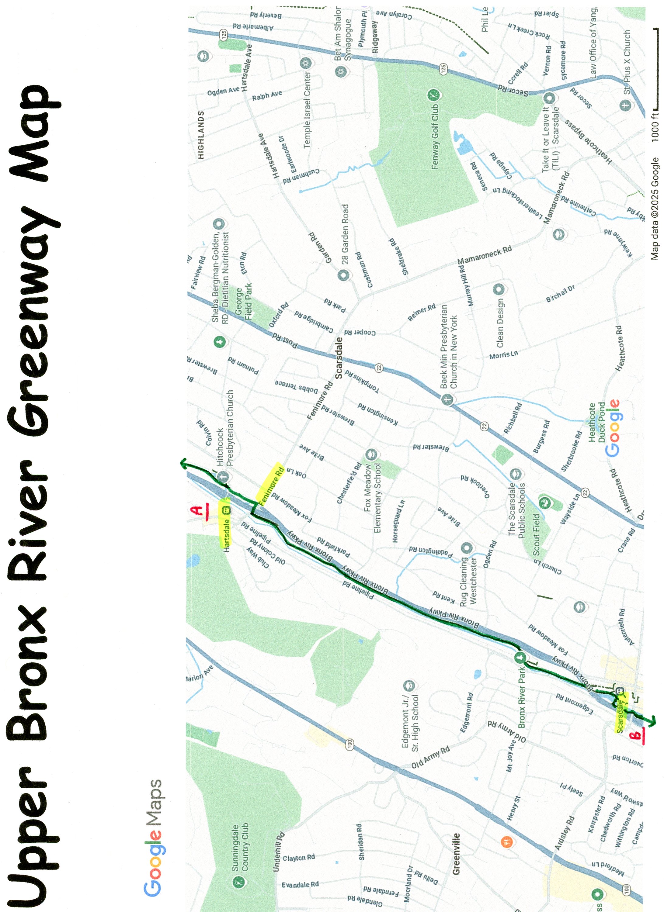
Starting from the Kensico Dam Plaza in Valhalla [Northern End]; The plaza is located directly below the massive dam. Quite a sight. There is a pavilion, rest rooms and refreshments available when the pavilion is open. The road across the top of the dam is closed to vehicles, however, I believe it is open to pedestrians. There were stairs located along each side of the dam. Head to the East Side of the dam where you'll find an interesting memorial to the 9-11 victims. The paved Upper Bronx River Greenway starts here, travels South, along the plaza and past the entrance where a crosswalk takes you over N Broadway. The trail travels left, under the stone arched Bronx River Pkwy Bridge, crossing into North White Plains. The trail then turns right and alongside Clove Road Park. As you travel up a small rise it will become wooded on your left. Pass by 3 Cedar trees along your right, then a large rock next to a tree on your left followed by a clump of 4 trees. Look past these trees up into the woods and spot a large rock about halfway up. Behind it is a long rock ledge. Just to the right and below this ledge will be a large flat rock. Underneath the front edge, remove 1 flat rock to reveal the BRONX RIVER GREENWAY LETTERBOX. Continuing along the trail, you'll cross over the Metro-North rail line via a Bronx River Pkwy bridge. Beautiful old brick and stone bridge with a good view of the dam. The trail travels between the Parkway and the rail line and alongside the river in the Greenway. The trail meanders and travels up and down small hills, sometimes close to the Parkway or river or rail line. After 1.1 miles, use caution at a busy road crossing. After 1.7 miles you'll pass by a pond on your left and come to Fisher Lane. Turn left and pass by the Metro-North parking lot where the trail picks up on your right. You travel alongside the parking lot and pass by the entrance for the North White Plains Station. When you come to the tunnel underneath the tracks on your left, turn right and cross the road to the trail. Cross over the river and some busy road crossings before coming to a parking lot at 3.1 miles. The trail travels through the lot with a spur on the right to the County Center. You'll then pass by a tunnel to the White Plains Station in White Plains. Check out the clock tower up to your left. The trail travels alongside the river and through a tunnel before crossing back over the river on the Muskrat Bridge. We spotted all types of birds along the trail including Geese, Ducks and Egrets. You'll travel underneath the impressive Woodland Place Viaduct (Bronx River Pkwy Bridge) before traveling underneath the railroad tracks. The trail changes from paved to stone-dust at 4.4 miles and alternates between the two for a bit as you cross into Scarsdale. Watch your head at 4.8 miles as you travel under the Pkwy via a low arched bridge. This section is a bit more tranquil as it passes alongside a residential neighborhood. Come to a dam and small waterfall followed by a small pond in a park. Come to Greenacres Ave after 5.5 miles. Heading right brings you to the Hartsdale Station. I haven't checked out this next section yet. Cross the road and travel right down Fountain Terrace. Soon you'll pick up the paved trail which takes you out to Fenimore Rd. Head right across the Bronx River Pkwy, then left where you'll rejoin the paved trail as it travels South, along the Western Side of the Pkwy. Just before you reach the Bronx River Reservation Maintenance Area the trail turns right and travels underneath the RR tracks, the continues South, alongside the Bronx River. You'll come to the Scarsdale Station after 7.3 miles. I've checked out this next section. Continue South, by crossing over the dam via the whimsical Waterfall Bridge. The trail follows alongside the river and crosses several wooden bridges. This section is very well done. Duck! At 7.9 miles is an extremely low bridge followed by an iron bridge over the river. A cross-light takes you over busy Harvey Rd. Restrooms are available at 8.7 miles at a rest stop for the Pkwy on your right. Just past this the trail briefly follows along a service road before coming to a park. Left brings you to the Crestwood Station. The trail travels alongside Crestwood Lake (Bronx River) before you come to an intersection.
Note; Left, South, leads to Parkway Oval Park.
Head right, North, across the Bronx River via a dam. Here the trail pulls away from the river and back South, along the Parkway. You'll come alongside an on-ramp and the trail abruptly ends at 11.1 miles. A short 0.2 mile on-road section utilizes a BIKE LANE before you pick up the paved trail again. After crossing over Tuckahoe Rd you'll enter another park and come to a split in the trail at 11.5 miles. Both routes take you around Bronxville Duck Pond, however, right takes you alongside the Pkwy so continue straight. You'll cross over another dam at the mouth of the pond where both trails merge. When you come to another split in the trail, bear left out to Pondfield Rd.
Note; Trails travel along both sides of the river South, from Pondfield Rd to Palmer Rd.
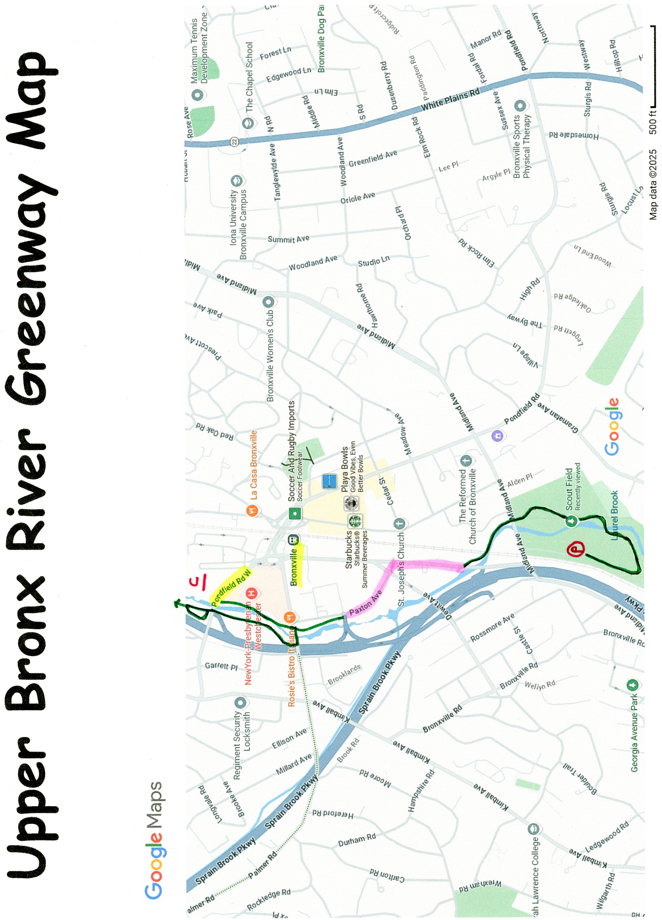
Cross Palmer Rd and travel through another small park along the West Side of the river. Come to Palmer Rd and travel left across the bridge and the paved trail will continue on your right (stairs). I haven't checked out this next new section yet. Continue South, along the East Side of the river to Stone PL & Paxton Ave at 12.5 miles. Map Board. Gap. Short on-road detour.
Note; Across Paxton Ave is Maltby Park. Playgrounds, sports courts and a short, paved Loop Trail.
Continue South, on-road, along Paxton Ave. You can utilize a short paved trail along your left in Maltby Park. Cross DeWitt Ave and travel right, on-road, along Parkway Rd (residential) back to the river, where you'll re-join the paved trail on your left at 12.8 miles. The trail travels alongside the river, traveling underneath a RR bridge, followed by the Midland Ave bridge. The trail then travels past Scott Field (ball field) before crossing a bridge over the river. The trail then turns North, bringing you to the Bronxville Boy Scout parking lot after 13.4 miles.
Note; A large Gap exists between the next completed section as of 2025.
Note; To connect to the next section. From the Bronxville Boy Scout parking lot; Follow the road North, to Midland Ave. Travel left, South, on-road (Not recommended for novice bikers) along Midland Ave, which becomes Bronx River Rd. Turn left on Oak Street and an immediate left at the Bronx River Pkwy on-ramp, where the trail begins after 1.7 miles.
Southern Section:
Starting from Oak Street in Yonkers; This trail Dead Ends. The paved Bronx River Greenway travels North along an on-ramp for the Bronx River Pkwy, before heading right across a bridge over the Bronx River where it continues North between the river and RR tracks. The trail splits briefly before dead ending after only 0.7 miles between the Bronx River Pkwy and RR tracks. Only option is to retrace your route back to Oak St.
Note; A large Gap exists to the Lower Bronx River Greenway, as of 2025.
Note; To connect to the Lower Bronx River Greenway, at the Metro-North's Woodlawn Station in the Bronx, return to Bronx River Rd and head left, South, on-road (Not recommended for novice bikers). The Bronx River Rd becomes Webster Ave. Turn left into the Metro-North's Woodlawn Station after 1.6 miles. See Below.
LOWER BRONX RIVER GREENWAY:
Starting from the Metro-North's Woodlawn Station; [Re-zeroing Mileage]
Note; The paved Lower Bronx River Greenway Heads North, along the Bronx River through Muskrat Grove before traveling underneath the Bronx River Pkwy. Here it travels between the river and Pkwy before it turns right crossing a bridge over the river and abruptly ending after 0.6 miles in Westchester County.
Note; A large Gap exists to the Lower Bronx River Greenway, as of 2025.
Starting from the Metro-North's Woodlawn Station; [Re-zeroing Mileage]
Note; A paved trail heads South, underneath the E233rd Street Bridge and then dead ends. Don't take this trail, although it looks like the logical choice.
Head out to Webster Ave and travel left up to 233rd St. Cross the street and head left over the RR tracks and the Bronx River Pkwy to Bronx Blvd. Here you'll pick up the paved Lower Bronx River Greenway as it travels South. Cross over an on-ramp for the Pkwy and the trail pulls away from Bronx Blvd and closer to the Bronx River, although you don't get great views of it. Travel past the 227th Street Playground and through Shoelace Park & Hyman Park before crossing E Gun Hill Rd at 1.5 miles. Come to an intersection at 2 miles in Bronx Park.
Note; Heading right, the trail heads Southwest, through Bronx Park towards the Botanical Gardens and intersects with the Mosholu-Pelham Greenway after a 0.5 miles.
Continue straight heading South. This section is in better shape, but more hilly. The trail is divided into bike and pedestrian lanes. The trail splits, but all trails rejoin. You'll come to Allerton Ave at 2.4 miles.
Note; Heading right, West, the Mosholu-Pelham Greenway takes you alongside Southern Blvd through Bronx Park and towards the Botanical Gardens.
Continue straight, using the cross-light (a tough intersection to cross) and travel South, along the combined Lower Bronx River/Mosholu-Pelham Greenways. The trail splits several times, but always rejoins further South. After a little over 2.7 miles you'll pass by Warring Playground. Restrooms and a water fountain are located here. You come to Boston Rd at 3.2 miles.
Note; The Mosholu-Pelham Greenway continues East, alongside the Bronx & Pelham Pkwy.
Cross Boston Rd and the Bronx & Pelham Pkwy following a double-wide sidewalk along Boston Rd to Pelham Pkwy. Head right across Pelham Pkwy to a paved trail into Lower Bronx Park. Pass by Bronx River Dog Park before crossing Boston Rd again.
Note; Right leads to the BRONX ZOO .
Trail splits around Ben Abrams Playground and restroom, through the center of the park, past sports fields, before coming to an intersection at 3.7 miles.
Note; Continuing left, East, will take you past the Brady Playground and bring you up to the intersection of Bronx Park E & Unionport Roads
Head right, South, along the paved trail past the basketball courts. The trail then travels alongside the Bronx River Pkwy before traveling down to the Parks building. Turn right, on-road, past the Parks Dept and pick up the paved trail again on your right at 4.2 miles. Travel underneath the Bronx River Pkwy (isolated section), past Unionport Rail Yards & station and out to E 180th St at 4.5 miles. Travel right, on-road (wide sidewalk available) along E 180th. Just after the sidewalk narrows come to 2 cross-walks. Take the 2nd cross-walk over to Devoe Ave and continue along E 180th along a wide sidewalk back across the Bronx River where the paved trail picks up on your left at 4.7 miles. I haven't checked out this new addition.
Note; I believe if you head North, a trail takes you underneath E 180th St to River Park (playgrounds, picnic tables & Splash Park).
This wooded trail travels South, through West Farms Rapids Park underneath the elevated train tracks out to E Tremont Ave.
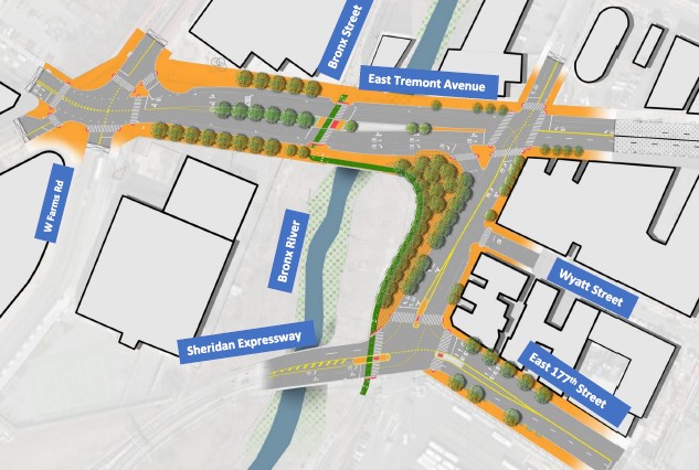
Note; A short Gap exists as of 2025. Future construction will take the trail across E Tremont St, then East, across the river, then South, to the Sheridan Expressway and a crosswalk to the existing section. This will bypass the dangerous current route along E 177th St. Groundbreaking commenced Dec. 2025. See; Map Below.
Current Detour; Head left to a cross-lights over E Tremont Ave and continue south on E 177th St (No shoulder). You will pick up the paved trail at the next intersection after 5 miles.
I've checked out this next section. The trail travels South, underneath I-95 bringing you to *Starlight Park Circle, where the trail creates a circle at 5.3 miles. Sculptures and a remnant of an old RR catenary here. A catenary is a system of overhead wires used to supply electricity to a locomotive vehicle which is equipped with a pantograph. The pantograph presses against the underside of the lowest overhead wire, the contact wire. This old RR catenary was used by the former NY, Westchester & Boston Railway, which was an electric commuter railroad in the Bronx and Westchester County from 1912 to 1937.
Note; You have 2 Options from here:
Option 1: I haven't checked out this new trail section. Two trails travel South, from *Starlight Park Circle, underneath E 174th St, where they join together. The trail then travels between the Eastern Side of the River and RR tracks, bringing you to the **Bronx River House Bridge after 0.4 miles.
Note; This bridge will take you over the Bronx River to Starlight Park.
The trail then continues South, before turning North, then East, over the RR tracks.
Note; A ramp on your left will take you East, out to Bronx River Ave & E 172nd St.
The trail continues South, alongside the RR tracks to another pedestrian bridge over the Bronx River, next to a RR bridge. You then travel between the river and RR tracks to ***Westchester Ave after 0.8 miles.
Option 2: I've checked out this section. From *Starlight Park Circle, head right across a blue bridge over the Bronx River, then South, underneath E 174th St. Here the trail follows the Western Side of the River, around the Eastern Side (more scenic) of the Park (sports fields and playground). Another trail circles around the Western Side of the Park, paralleling Sheridan Blvd. Come to the **Bronx River House Bridge at 5.5 miles.
Note; This bridge crosses the Bronx River to the Eastern Side of the River. See; Option 1 Above. I would continue along this route, as it is much more scenic.
Continue right, West, past the Bronx River House, to the Western Side of the Park, then South, past a sitting area, where the Edgewater Road 2 WAY BIKE LANE takes you South, up to ***Westchester Ave after 0.7 miles.
I've checked out this next section. From ***Westchester Ave [6.1 miles]; Cross Westchester Ave, where the paved trail resumes South, alongside the Western Side of the River, as you enter Concrete Plant Park. Come to the remnants of the old concrete plant along with a pavilion, benches and water fountain. Old RR tracks preserved here. Come to an intersection just before Bruckner Blvd at 6.5 miles.
Note; I haven't checked out this new trail section. A Spur Trail on your left will take you South, underneath Bruckner Blvd and through Garrison Park, across some RR tacks to Edgewater Rd after 0.2 miles. Here, you can access the Garrison Ave BIKE LANE straight, West, ahead. If you head left, South, on-road, along Edgewater Rd (industrial area) it will bring you to Lafayette Ave and Hunts Point Riverside Park on your left after 0.4 miles. Fishing pier, canoe launch and playground.
Continue straight from the intersection up to Buckner Blvd. A 0.5 mile on-road detour currently exists between here and Soundview Park. Head left, East, along a wide sidewalk, across the river and down to Bronx River Way. Head right, South, along Bronx River Way (BIKE LANE & SHARROWS), then left along Story Ave (BIKE SHARROWS). First right down Colgate Ave (BIKE LANE) and you'll come to Lafayette Ave and Soundview Park at 7 miles.
Soundview Park:
Map Board. [Continuing Mileage] Enter the park, along the paved Lower Bronx River Greenway, passing by the Butterfly Meditation Garden, before quickly coming to the 1st Intersection.
Note; Left, East, will take you to the Eastern Side of the Park. I returned via this route.
Continue straight, Southeast, through the park, along the Western Side of the Park, as the trail follows the Bronx River along your right. Pass by some sports fields before entering the woods. Come to a 2nd Intersection at 7.6 miles.
Note; Left, North, will take you back along the Eastern Side of the Park. I returned via this route.
Continue straight, Southeast, along the Western Side of the Park, along the river, passing by several spurs along your left. Just keep right along the river. At 8 miles you pass a promenade overlooking where the Bronx River meets the East River. Rikers Island and LaGuardia Airport are across the river. The trail now turns East. Pass by the 3rd Intersection (final intersection) before the trail heads inland past a marsh bringing you to Leland & O'Brien Avenues after 8.5 miles and the end of the trail.
Note; Straight, East, on-road along O'Brien Ave, will bring you to the Pugsley Creek/Castle Hill Parks Trail after 0.3 miles. I haven't checked out this trail. This 1.2 mile paved trail encircles Pugsley Creek Park and Castle Hill Park with Westchester Creek in the middle.
Note; Right, South, on-road, down Leland Ave/Bronx River Ave will bring you to the Shore Haven Bike Path and Clason Point Park Path after 0.4 miles. I haven't checked out these trails. This 1 mile trail follows the Shore Haven Bike Path along the East River before it connects to the Clason Point Park Path which travels north alongside Westchester Creek.
Note; On my return trip I utilized trails along both the Western & Eastern Sides of the Park. [Re-zeroing Mileage] Return West, to the 3rd Intersection and head right, North, inland along the paved trail, passing by the Soundview Park Amphitheater, before coming to an intersection.
Note; Straight will bring you out to Bronx River Ave.
Head left, South, back past the Soundview Park Amphitheater to the Eastern Side of the Park and continue right, West, quickly coming to another intersection. Head right, North, inland along the paved trail, keeping straight until the trail turns left, West, next to a dirt path. This returns you to the Eastern Side of the Park, where you continue right, North, along the river. Returning to the 2nd Intersection at 1 mile, you'll now head right, North, inland along the Western Side of the Park. Keep straight and you'll come to a circle.
Note; Right, East, leads left to Randall Ave.
Continue straight, North, as 2 trails parallel each other past the Metcalf Playground on your right and the Hector Aponte Track and Field on your left. Keep straight past the next circle and you'll come to an intersection at 1.4 miles.
Note; Straight leads left to Lafayette Ave.
Continue left, West, passing by another playground and Splash Park, followed by a Dog Park and sports field before returning to the 1st Intersection and the Eastern Side of the Park. Turn right, North, out to Lafayette Ave after 1.8 miles.
HH
CLICK HERE FOR UPPER BRONX RIVER GREENWAY MAP
CLICK HERE FOR UPPER BRONX RIVER GREENWAY A-B MAP
CLICK HERE FOR UPPER BRONX RIVER GREENWAY C MAP
CLICK HERE FOR LOWER BRONX RIVER GREENWAY MAP
CLICK HERE FOR CLASON POINT/CASTLE HILL/SHORE HAVEN PATHS MAP
CLICK
HERE FOR NY CITY 2025 BIKE MAP
LETTERBOX LAST VERIFIED ON
SEPTEMBER 27, 2025
TO EMAIL A VERIFICATION
bikeitorhikeitcontact@gmail.com
BEFORE YOU SET OUT BE SURE TO READ THE
WAIVER OF RESPONSIBILITY AND DISCLAIMER
BIKE IT OR HIKE IT