BACK RIVER TRAIL:
NORTH WEYMOUTH, MASSACHUSETTS
BARE COVE PARK:
HINGHAM, MASSACHUSETTS
WEBB MEMORIAL STATE PARK LOOP TRAIL:
NORTH WEYMOUTH, MASSACHUSETTS
STODDERS NECK & ABIGAIL ADAMS STATE PARK:
NORTH WEYMOUTH & HINGHAM, MASSACHUSETTS
-BIKE IT OR HIKE IT-
Last Updated: April 12, 2025
Length: Back River Trail; 2.1 miles
Bare Cove Path; 1.7 miles
Osprey Overlook Park Loop Trail; 0.9 mile Loop
Indian Point Loop; 3.1 miles
Webb Memorial State Park Loop Trail; 1.5 mile Loop
Stodders Neck Loop; 0.6 miles
Abigail Adams SP Loop Trail; 0.6 miles
Difficulty: Back River Trail; Moderate to Difficult. Hilly, old abandoned paved road. A couple of very steep hills. Not recommended for kids on bikes.
Osprey Overlook Park Loop Trail; Moderate. Hilly paved trail w/a hard packed dirt/gravel section.
Bare Cove Path; Easy. Relatively flat, abandoned paved road.
Indian Point Loop; Moderate. Hilly, abandoned paved roads with a some hard packed dirt roads.
Webb Memorial State Park Loop Trail; Easy. Flat, stone-dust trail.
Directions:
From Route 3A in Quincy, head east over the Weymouth Fore River Bridge to North Weymouth.
For Webb Memorial State Park in North Weymouth; From the Weymouth Fore River Bridge; Travel 1.4 miles and turn left on Neck St, which turns into River St. Come to the park after 1.5 miles. Parking lot on the left.
For Abigail Adams State Park in North Weymouth; From the Weymouth Fore River Bridge; Travel 1.7 miles and just before you cross the bridge over the Weymouth Back River, turn left into the State Park. Turn right to park.
For Stodders Neck Reservation in Hingham; From the Weymouth Fore River Bridge; Travel 2 miles, crossing the bridge over the Weymouth Back River to Hingham and turn left into the Park.
For the Back River Trail and Great Esker Park parking lot in North Weymouth [Northern End]; From the Weymouth Fore River Bridge; Travel 1.7 miles and just before you cross the bridge over the Weymouth Back River, turn right into the shopping plaza and immediately turn left to a small parking lot.
For the Bare Cove Path Beal Street parking area in Hingham [Northern End]; From the Weymouth Fore River Bridge; Travel 2 miles, crossing the bridge over the Weymouth Back River to Hingham and turn right on Beal St. Take your first right to a parking area where an old road starts (now blocked by a fence). Bare Cove Path starts here. There is also a main parking lot located in Bare Cove Park. To access, continue along Beal St/West St and bear right along Fort Hill St. Take your first right along Bare Cove Park Dr to the Bare Cove Park parking lot.
The North-South Back River Trail follows the West Side of Weymouth Back River, while the North-South Bare Cove Park Trails follows the East Side of Weymouth Back River. Both trails accessed from the North, at Route 3A. You may connect between these 2 trails via Route 3A (0.5 miles East-West, along a narrow sidewalk next to a busy road).
North of Route 3A are 3 parks. You can check out Stodders Neck Reservation & Abigail Adams State Park which both have short Loop Trails. You can access the 3rd park, Webb Memorial State Park, which also has a Loop Trail, via an on-road route. It is located further North of Route 3A.
Back River Trail:
The Back River Trail follows an abandoned road South, through Great Esker Park and travels along the West Side of Weymouth Back River (a tidal River). An esker is formed by a stream or river in a tunnel underneath a glacier. It is made up of the sediments dropped by that stream or river. When the glacier retreats, the deposits remain, exposing a long, winding hill where the stream or river used to be. The park features the highest esker in North America. It ends at Osprey Overlook Park. For more information visit; BACK RIVER TRAIL .
Starting from the Great Esker Park parking lot [Northern End]; A Porto-Potty is located here. The Back River Trail travels past the green gate along an old paved road. You travel South, along the road past the commercial district on your right and into the woods. After 0.5 miles you begin a steep climb up a short hill. Travel along the esker with steep drop offs along both sides. Fleeting glimpses of the river. Travel down a steep hill to river level at 1.4 miles. Puritan Road parking area here with Porto-Potty. Open views of the river. Pass by a boardwalk and travel along an inlet to a sharp left next to an *Intersection at 1.8 miles.
Note; This is the connection to Osprey Overlook Park. See Below.
The road then turns North, between the inlet and the river to a small island. Check out the Osprey nests across the river. The road ends after 2.1 miles at a gravel beach overlooking the river. Across the river is Bare Cove Park.
Osprey Overlook Park Loop Trail:
From the Back River Trail *Intersection, a paved path on your right leads to Osprey Overlook Park. [Re-zeroing Mileage] Here you can follow the paved Osprey Overlook Park Loop Trail straight, South, to second **Intersection. This park sits atop a covered landfill, thus all the venting pipes. The Loop Trail starts here, but first head straight, East, to an overlook of the Weymouth Back River. Return back to the **Intersection and Loop right, North, along a gravel trail (if biking utilize the single track dirt & grass path) which takes you South, down alongside the marsh & river. Here the trail is hard packed dirt. The trail turns West, bringing you to the Wharf Street parking lot at 0.5 miles. Map Board. Follow the paved trail right, North, to a short stone-dust Loop Trail on your left, that Loops around a field and returns you back to the paved trail. Head left, North, up a slight hill and return to the **Intersection. Continue left, back to the *Intersection & Back River Trail after a 0.9 mile Loop.
Bare Cove Park:
Bare Cove Park is located along the East Bank of the Weymouth Back River (a tidal river). Prior to 1906, the land was privately owned. The site was acquired by the U.S. Navy and used as an ammunition depot until 1971. In 1972, Bare Cove Park was set aside as a wildlife sanctuary and a place for public recreation. The old abandoned roads now form a network of trails throughout the park. Bare Cove Path travels South, from Route 3A to the Bare Cove Park parking lot. Indian Point Loop consists of several paths combined to form a Loop Trail along the Southern portion of the park around Indian Point. There are many paths to choose from. For more information visit; BARE COVE PARK .
Bare Cove Path:
Starting from the Beal Street parking area [Northern End]; Just past the fence the Bare Cove Path follows an old road South, which leads you to the Weymouth Back River. A dirt path on your left leads to the Bunker Alley Path. Here you'll find Map G, as noted on the Map. These Maps are located throughout the park. The trail travels alongside the river. Pass by the Bunker Alley Path and you'll come to Sheltry Path on your left. Here you'll find Map B.
Note; The Sheltry Path leads North, to Lynch Fields and another parking lot off Beal Street.
The trail travels East, around a Cove before briefly turning inland. Come to a green building along the river after 0.8 miles (USS YF-415 Memorial; The Naval ship USS YF-415 was operating out of the Hingham Naval Ammunition Depot at the time. While conducting a routine dump of obsolete ammunition 14 miles off Nahant, an accident aboard the ship cost the lives of 17 men.). Picnic tables here. The trail turns inland again passing by Beal Cove. Come to the ***Median Garden Intersection after 1.5 miles.
Note; The Indian Point Loop starts here. See Below.
Continue straight, East and you'll come to the Bare Cove Park parking lot after 1.7 miles. Map A.
Indian Point Loop:
Starting from Bare Cove Park parking lot [Southern End]; You'll find Map A located just past the gate. Bare Cove Path starts here and follows the old road West. You'll quickly come to the ***Median Garden Intersection.
Note; The Bare Cove Path continues straight, West. See Above.
The Indian Point Loop begins on your left. Follow South, to an intersection, where you'll find Map C. These Maps are located throughout the park. Head left, Southeast, along the Conservatory Path. There are many side trails and intersecting trails. Keep left at all road intersections as this Loop travels the outer edge of the park. Some small hills along this route. Traveling South, pass an outdoor amphitheatre. Continue left, West, along Fresh River Path at 0.8 miles. Continue staying left and soon you'll be traveling alongside the Fresh River floodplain and Indian Point. This old road ends at a rocky beach overlooking the Weymouth Back River. Across the river is the Back River Trail. Head back along the road and take your first left along a hard packed dirt path. This brings you past a scenic knoll with a picnic table overlooking the river and out to Indian Point Path. Head left, North, along this old road which affords nice views of the river. At your next intersection continue straight, East, to an open intersection. Here you'll find Map F. Head left, North, along the wide Bridges Path, which brings you to the Back River Path. Here you'll find Map E. Turn left and follow this road Northwest, back to the Conservatory Path and Map C again. Turn left, North and complete your Loop by returning to the ***Median Garden Intersection & Bare Cove Path after 3.1 miles.
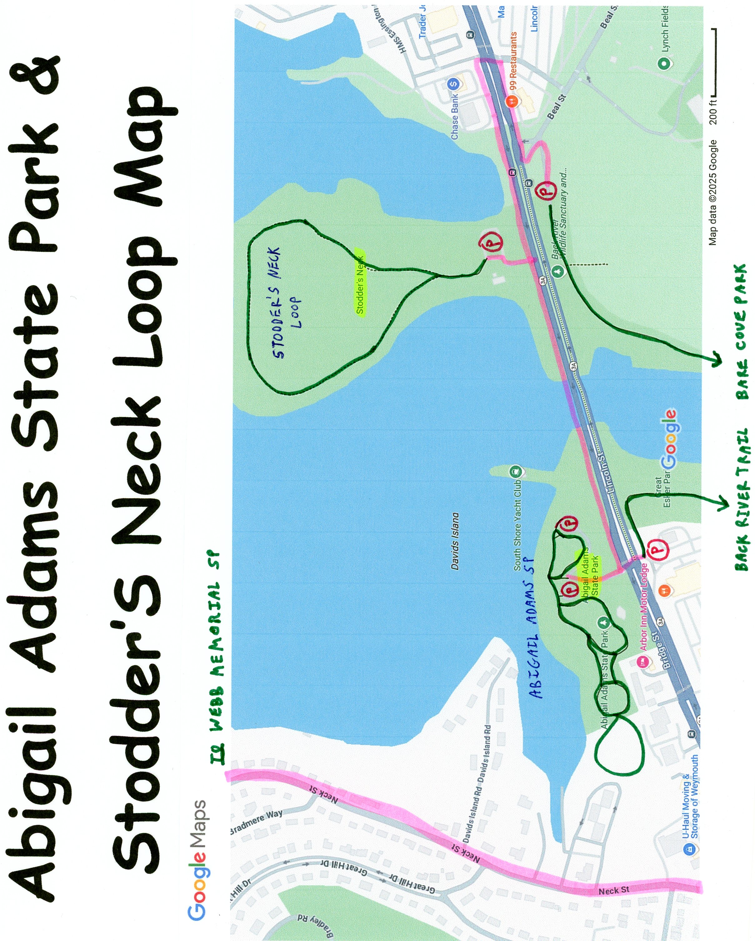
Stodders Neck & Abigail Adams State Park:
Stodders Neck Reservation is a peninsula at the mouth of the Weymouth Back River. Abigail Adams State Park is located next to the Weymouth Back River. Abigail Adams (née Abigail Smith) was born in Weymouth, MA. She was the wife of second US President John Adams and the mother of sixth US President John Quincy Adams and is remembered as an early proponent of women’s rights. The park features some of her quotations, displayed on plaques.
Stodders Neck Reservation:
Starting from the Stodders Neck Reservation parking lot; This is a popular Dog Park. A hard packed dirt & gravel trail Loops 0.6 miles around the small peninsula.
Abigail Adams State Park Loop Trail:
The paved Abigail Adams SP Loop Trail starts from the South Shore Yacht Club boardwalk next to the Weymouth Back River. The trail then travels West, along the river to a traffic circle. Keep right along the open grass. This will bring you to the Kibby Property Loop, where you head into the woods and Loop back to the Abigail Adams SP Loop Trail. You then travel back right along the paved trail back to the traffic circle where a path travels around the parking lot back to the South Shore Yacht Club boardwalk. 0.6 mile Loop.
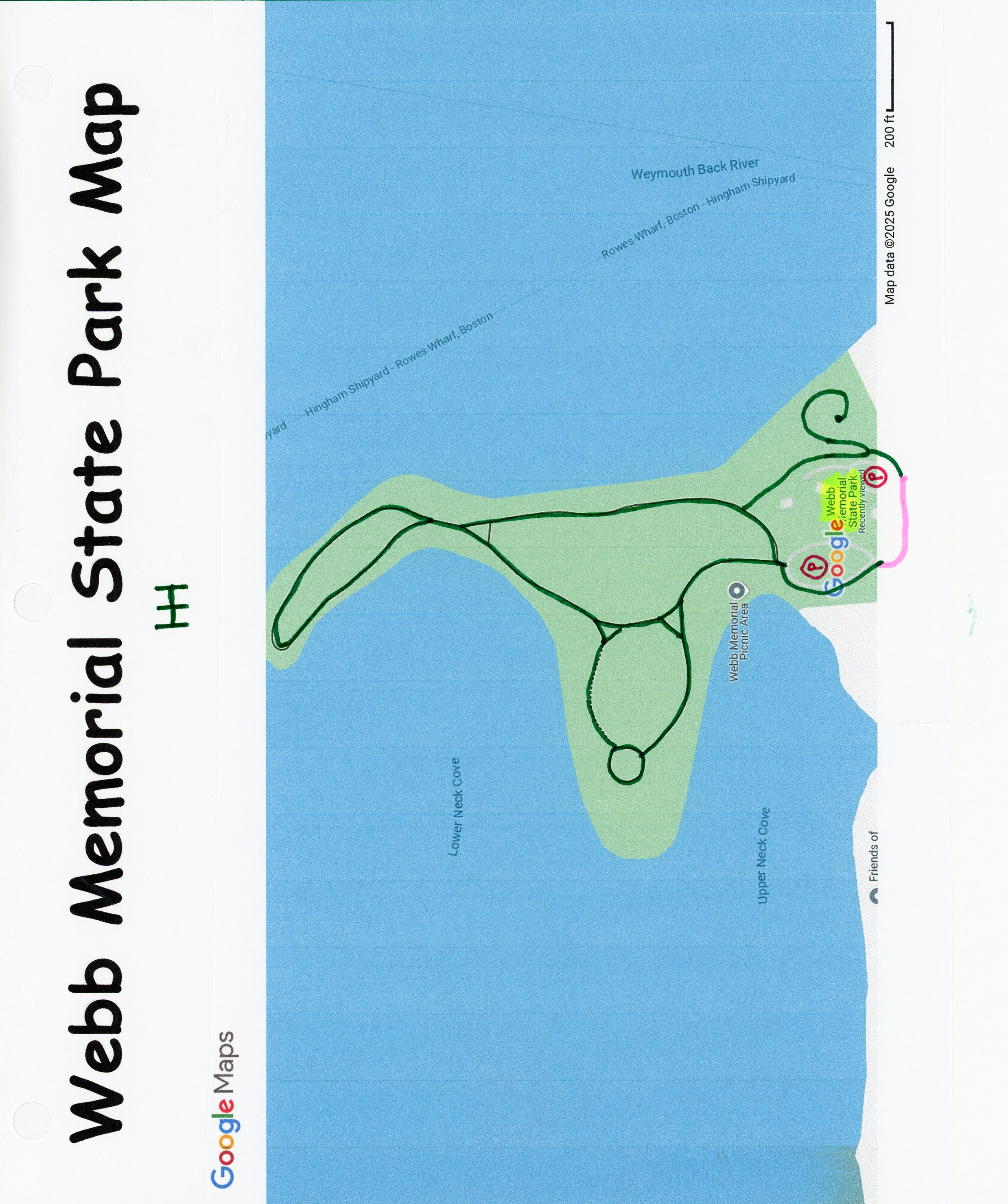
Webb Memorial State Park Loop Trail:
Webb Memorial State Park is located at the end of Weymouth Neck, a peninsula that extends into Hingham Bay. In 1775, during the Revolutionary War, a skirmish took place nearby, between local colonists and crews of British ships. The British had anchored at Loyalist-owned Grape Island, to obtain hay for their horses in Boston. Local militiamen fired upon them, drove them away, and then burned down the barn where the hay had been stored. This incident became known as the Grape Island Alarm. It was the second armed confrontation of the American Revolution. The Webb Memorial SP Loop Trail loops around the peninsula. See; WEBB MEMORIAL SP .
Starting from the entrance to Webb Memorial State Park [Southern End]; The crushed gravel Webb Memorial SP Loop Trail travels North, around the Main parking lot to a Map Board. Head left past the picnic area along the Western Side of the peninsula to an intersection and continue left along the stone-dust trail. This brings you to a Memorial surrounded by seating and Mugo Pines. Continue right, East and come to another intersection where you'll head left, North. This brings you to another intersection. Lower Neck Cove & Weymouth Fore River on your left, along with views of Boston. Continue straight then bear left which will bring you to the Northern Tip of the peninsula at 0.7 miles. Views of Boston & East Boston to your left and Grape Island to your right. You now Loop South, back along the Eastern Side of the peninsula, following the Weymouth Back River. Pass by another Memorial to a Revolutionary War skirmish. Keep left at the next 2 intersections. Cross a small bridge next to Mary's Point and travel above the Secondary parking lot to an intersection. Here, if you head left, North, it will take you up a knoll to an overlook of the Weymouth Back River. Return to the intersection and continue left. This brings you out to the Secondary parking lot. Head left, West, on-road to the Main parking lot and complete your 1.5 mile Loop.
HH
CLICK HERE FOR BACK RIVER TRAIL MAP
CLICK HERE FOR BARE COVE PARK ROUTE MAP
CLICK HERE FOR BARE COVE PARK MAP
CLICK HERE FOR WEBB MEMORIAL STATE PARK MAP
CLICK HERE FOR ABIGAIL ADAMS SP & STODDERS NECK ROUTE MAP
BEFORE YOU SET OUT BE SURE TO READ THE
WAIVER OF RESPONSIBILITY AND DISCLAIMER
BIKE IT OR HIKE IT