MARTHA'S VINEYARD BIKE PATHS:
MARTHA'S VINEYARD, MASSACHUSETTS
-BIKE IT OR HIKE IT-
Last Updated: February 16, 2025
Length: A Edgartown-Vineyard-Haven Road/Upper Main Street Bike Path; 6.5 miles
B Beach Road Bike Path; 0.8 miles
C Country Road Bike Path; 3.2 miles Have not done this path.
D Beach Road/Seaview Ave Bike Path; 4.3 miles
E Katama Road Bike Path; 2.6 miles Have not done this path.
F Herring Creek Road Bike Path; 2.2 miles Have not done this path.
G Edgartown-West Tisbury Road Bike Path; 7.3 miles Have not done this path.
H Barnes Road Bike Path; 2.5 miles Have not done this path.
I State Forest Bike Path; 6 miles Have not done this path.
Vineyard Haven Ferry Terminal to Edgartown [A]; 7.8 miles
Edgartown to Oak Bluffs Ferry Terminal to Vineyard Haven Ferry Terminal [A & B & D]; 8.6 to 9.5 miles
Edgartown to South Beach SP Loop [E & F]; 7 mile Loop Have not done these paths.
Difficulty: Vineyard Haven to Edgartown; Moderate. Paved, hilly path.
Edgartown to Oaks Bluff; Easy. Paved flat path.
Oak Bluffs to Vineyard Haven; Moderate. On-road with some hills.
Directions:
To take the ferry from Woods Hole to Vineyard Haven Ferry Terminal; Take Route 28 south to Falmouth, then bear right on Locust St, which becomes Woods Hole Rd. This brings you right to the ferry. For more information visit; THE STEAMSHIP AUTHORITY .
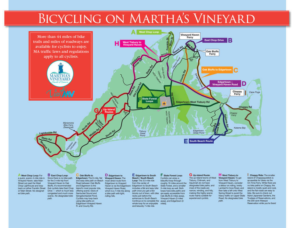
There are several multi-use paths on the island of Martha's Vineyard and they all, with the exception of the State Forest Loop Trail, follow alongside roads. They are concentrated along the Eastern Side of the island, with the State Forest Loop Trail located in the center of the island. The Western End of the island has no multi-use trails. There are many on-road routes throughout the island and you'll need to utilize on-road routes to connect between multi-use trails and the ferries.
We biked a Loop from Vineyard Haven to Edgartown to Oaks Bluff and back to Vineyard Haven utilizing the Bike Paths and on-road routes. There are several ferries over to the island, the closest one leaves from Woods Hole, MA. You can take your bike on the ferry and easily plan a day trip as the ride over is only 45 minutes long. We utilized the Shinning Sea Bikeway in Falmouth which brings you right to the Woods Hole Ferry and took the ferry to Vineyard Haven. The ferry also goes to Oak Bluffs, so you can return from either port. For more information visit; BIKING MARTHA'S VINEYARD .
Starting from the Vineyard Haven Ferry Terminal in Vineyard Haven [Northern End]; After exiting the ferry continue straight out to Water St and head left, South, on-road along this congested narrow street. Quickly come to Beach Road at *5 Corners.
Note; Left, Northeast, on-road along Beach Rd (narrow paved path available), will connect you to the Oaks Bluff Ferry Terminal. We Looped back this way.
Vineyard Haven to Edgartown:
[Edgartown-Vineyard Haven Road Path/Barnes Road Bike Path/County Road Bike Path/Beach Road-Seaview Ave Bike Path/Upper Main Street Bike Path/Edgartown-West Tisbury Road Bike Path/Katama Road Bike Path/Herring Creek Road Path]
From *5 Corners continue straight, South, on-road along Lagoon Pond Rd. This road is low volume and much more bike friendly. This brings you out along Lagoon Pond. Hang a right, West, up Skiff Ave (residential narrow road) and travel up a long gradual hill before coming to Edgartown-Vineyard Haven Rd at 1 mile. Use the cross-walk, then travel left, South, utilizing the wide shoulder before coming to the paved Edgartown-Vineyard Haven Road Path after 1.4 miles, next to Sanborn Way. This path follows alongside the road and is a bit hilly. Not much for scenery either. Basic point A to point B type trail. After 3.1 miles you come to the Barnes Road Traffic Circle.
Note; The paved Barnes Road Bike Path heads right, South and will quickly bring you to the State Forest Loop. Have not done this path.
Continuing straight, Southeast, you'll pass by County Rd on your left after 4.2 miles.
Note; Have not done this path. The 3.2 mile paved, County Road Bike Path travels North, to Eastville Ave. You can then travel left, on-road to Beach Rd and continue left, Southwest, on-road back to *5 Corners. Return to the Vineyard Haven Ferry Terminal for a 9 mile Loop.
Continuing straight, you cross the Edgartown town line. Just before you come to the intersection of Beach Rd and Upper Main St at 7.4 miles, will be a crosswalk over to the Beach Road-Seaview Ave Bike Path.
Note; The paved Beach Road-Seaview Ave Bike Path takes you North, to Oak Bluffs. We utilized this route, after exploring Edgartown, to check out Oak Bluffs, then Loop back to the Vineyard Haven Ferry Terminal. See; Edgartown-Oak Bluff-Vineyard Haven Below.
Continuing straight the paved Upper Main Street Bike Path follows alongside Upper Main St and takes you past some places to eat along with some bike rental shops. Cross Cookie St and continue alongside Upper Main St, past Cannonball Park where, as the name implies, you'll find lots of cannons and cannonballs. The bike path ends at the intersection of Edgartown-West Tisbury Rd & Main St after 7.8 miles.
Note; The paved Edgartown-West Tisbury Road Bike Path heads right, West and will bring you to the State Forest Loop. Have not done this path.
Continue straight, on-road along Main St. The route is narrow at points, but traffic is slow. You'll come to Pease's Point Way at 8 miles.
Note: Have not done these paths. To access both the Katama Road Bike Path and Herring Creek Road Path that lead to South Beach State Park, head right, South, on-road along Pease's Point Way S and you'll cross S Water St/Clevelandtown Rd. The paved Katama Road Bike Path begins here at 0.5 miles. Come to the intersection for the paved Herring Creek Road Bike Path on your right at 0.8 miles.
The Katama Road Path continues South, to the Eastern Side of South Beach State Park after 3.1 miles, while the Herring Creek Road Path continues South, to the Western Side of South Beach State Park after 3 miles. Atlantic Dr connects both paths East-West, on-road 0.9 miles, so you can create a 7 mile Loop.
To check out Edgartown's Harbor and Lighthouse, which is about another mile, head left along Pease's Point Way N (green bike route signs). Take your first right along Pease's Point Way. Turn right down Morse St, then left along N Water St. This will bring you to a small overlook of the bay and a footpath down to the Edgartown Harbor Lighthouse & Beach. Very scenic. To return to Pease's Point Way, I would suggest continuing East, along N Water St and heading left along Starbuck Neck Rd. This route is low traffic and scenic. Turn left when you come to Fuller St which brings you back to Morse St. Right up Morse St then returns you to Pease's Point Way. Head left back to Pease's Point Way N, then left back to Main St. Turn right, Northwest, on-road along Main St, returning to the Edgartown-West Tisbury Road Bike Path & Upper Main Street Bike Path **Intersection.
Edgartown-Oak Bluffs-Vineyard Haven:
[Edgartown-West Tisbury Road Bike Path/Upper Main Street Bike Path/Edgartown-Vineyard Haven Road Path/Beach Road-Seaview Ave Bike Path]
From the Edgartown-West Tisbury Road Bike Path & Upper Main Street Bike Path **Intersection in Edgartown; Travel Northwest, to the Edgartown-Vineyard Haven Road Path & Beach Road-Seaview Ave Bike Path intersection. The paved Beach Road-Seaview Ave Bike Path travels North, alongside Beach Rd. Cross a bridge between Sengekontacket Pond on your left and Trapps Pond on your right, before coming to Edgartown Beach at 1.6 miles. You the travel between Sengekontacket Pond along your left and Nantucket Sound on your right. This section is completely out in the open with no shade. You cross Jaws Bridge and the Oak Bluffs town line at 2.5 miles. Here the pond and sound flow into one another. The Joseph Sylvia State Beach runs along this section. At 3.7 miles you cross another bridge and leave the beach behind. You head a bit inland passing the Farm Neck Golf Club along your left. Past Farm Pond Rd Beach Rd becomes Seaview Ave. Travel along a causeway between the sound and Farm Pond (check out the Loch Ness monster in the pond). The bike path ends at 4.8 miles. A crosswalk takes you over to the sound side of Seaview Ave and on-road along a seawall. A paved path runs along the beach and would be advisable for kids riding bikes, but may be crowded with beachgoers. Pass by Waban Park on your left and Inkwell Beach on your right. Pass by Ocean Park on your left and Oaks Bluff Town Beach on your right.
Note; Ocean Ave circles around Ocean Park (one-way) showcasing all the colorful cottages overlooking the park. Worth the quick detour.
You reach the Oaks Bluff Ferry Terminal after 5.5 miles. Head left, West, down Oak Bluffs Ave. Here you'll find plenty of shops and places to eat. After exploring the town continue straight, on-road along Lake Ave and past Oak Bluffs Harbor. Cross over a causeway between the harbor and Sunset Lake and you'll come to NY Ave & East Chop Drive on your right at 5.9 miles.
2 Options from here:
1. Continue straight, Northwest, on-road along NY Ave (narrow shoulder) to Towanticut St and & East Chop Drive at [6.8 miles].
2. Scenic & less trafficked route we took. Travel North, on-road up a slight hill along East Chop Drive, before riding high above the sound. Very scenic with unobstructed views. You'll come to the East Chop Lighthouse, located on the cliffs above the sound at 7 miles. You then head downhill, Southwest, passing by Crystal Lake on the left. You come to New York Ave & Temahigan Ave's at 7.7 miles.
Continue right, South, along Temahigan Ave, which will bring you to Eastville Ave.
Note; Left, East, on-road along Eastville Ave will quickly bring you to Country Rd on your right. Here, the 3.2 mile paved, County Road Bike Path travels South, to the Edgartown-Vineyard Haven Road Path.
Travel right, on-road along Eastville Ave and you'll quickly come to Beach Rd at 9.9 miles [9 miles]. Here, you'll pick up the paved Beach Road Bike Path, which travels Southwest, passing by Eastville Point Beach on your right and crossing over a draw bridge to Vineyard Haven, between Lagoon Pond on your left and Vineyard Haven Harbor on your right. The trail ends after 10.7 miles [9.8 miles].
Note; Plans were to extend the Beach Road Bike Path 0.5 miles Southwest, to *5 Corners, however, this plan was scrapped. There may be plans to create a BIKE LANE instead.
You now enter the industrial area of Vineyard Haven. You come to the intersection of Lagoon Pond Rd and Water St at *5 Corners. Head right, North, on-road along this congested narrow street, back to the Vineyard Haven Ferry Terminal after 9.5 miles [8.6 miles].
HH
CLICK HERE FOR MARTHA'S VINEYARD BIKE PATHS MAP
CLICK HERE FOR MARTHA'S VINEYARD BIKE PATHS MAP
CLICK HERE FOR LABELED BIKE PATHS MAP 1
CLICK HERE FOR LABELED BIKE PATHS MAP 2
BEFORE YOU SET OUT BE SURE TO READ THE
WAIVER OF RESPONSIBILITY AND DISCLAIMER
BIKE IT OR HIKE IT