HANOVER BRANCH RAIL TRAIL:
ABINGTON-ROCKLAND-WEST HANOVER, MASSACHUSETTS
-BIKE IT OR HIKE IT-
Last Updated: September 10, 2025
Length: Hanover Branch Rail Trail; 3.1 miles
Difficulty: Easy. Flat paved rail trail.
Directions:
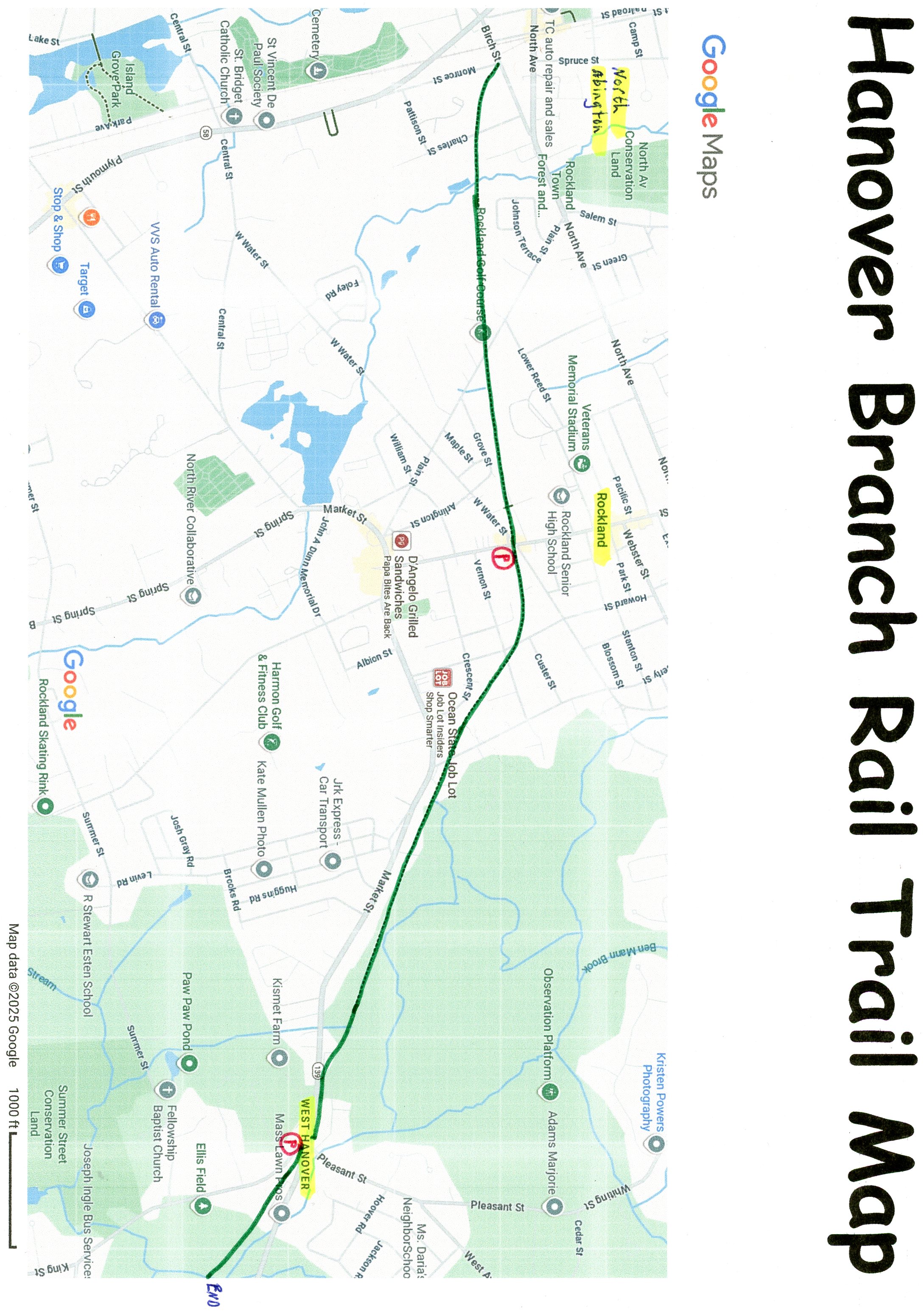
To Start from the Hanover Street parking lot in West Hanover [Eastern End]; From Route 3 take exit 35 to Hingham St. Between the Route 3 N & S exits off Hingham St take Pond St south which becomes Whiting St, which then becomes Pleasant St. This brings you to Market & Hanover St in West Hanover. Turn left on Hanover St. The parking lot will be on your right.
The Hanover Branch Rail Trail follows an old RR corridor of what was once known as the Hanover Branch Line. The line was built in the 1860s by E. Y. Perry, a Hanover businessman who produced tacks. The railroad originally ran for 7.8 miles from Hanover Four Corners, through West Hanover, across Rockland, to North Abington, where it connected with the Old Colony Railroad to Plymouth. The Old Colony Railroad absorbed the Hanover Branch in 1887. In 1893, the New York, New Haven and Hartford Railroad took over the lease. The railroad continued to operate well into the 20th century. In 1969, after Penn Central purchased it, the tracks were torn up from West Hanover to Hanover Four Corners. Currently, the trail travels West, from West Hanover, through Rockland and into Abington. For more information visit; HANOVER BRANCH RAIL TRAIL & ROCKLAND RAIL TRAIL .
Starting from the Hanover Street parking lot in West Hanover [Eastern End]; Map Board & some old RR tracks located here.
Heading East; The paved Hanover Branch Rail Trail travels East, into the woods. Pass by an old cement RR Whistle Post on your left. + See; RR Whistle Post Below. Come alongside Cushing Brook on your left before the trail ends after 0.3 miles at an old RR bridge over the Drinkwater River.
Note; Future plans call for continuing the trail Southeast, through West Hanover.
Heading West; The wide, paved trail leads to a narrow, paved trail leads left to a cross-walk over Circuit St, followed by another cross-walk over Market St. Head left along the narrow, paved trail and you'll pick up the paved Hanover Branch Rail Trail as it follows the old rail bed through the woods. Cross the Rockland town line at 0.5 miles. Pass by the Rockland Police Dept at 1.1 miles before crossing Liberty St. The trail now follows a residential corridor as you travel through Rockland. Cross Vernon St, then Howard St where you'll spot an old RR Marker A to your left. + See; RR Marker A Below. Keep an eye out right for an old RR Rail Holder, + See; RR Rail Holders Below. At 1.8 miles you pass by the old RR Depot and RR tracks on your left, as you pass by a kiosk and come to Union Street. Parking on your left. A couple of cross-walks will return you to the trail on W Water St. You head back into the woods along a residential corridor. Pass by the sports fields of Rockland High School before a cross-light over Route 139 at 2.3 miles. Another old cement RR Whistle Post on your left. Pass by the Rockland Gold Course along your left before you cross the Abington town line where you'll still find the old RR tracks in place. The trail then crosses Charles St before ending at Monroe St after 3.1 miles. If you head right up to Birch St and look left across the road you'll see where the old RR tracks connected to an active RR line.
Old Railroad Equipment:
+
RR Whistle Post:
The Whistle Post,
was a post with a large "W" engraved or painted on it. This
meant the railroad engineers were to start sounding the trains Whistle.
The Whistle posts
were usually placed 0.25 miles
in advance of a road crossing,
bridges, tunnels and other points. Usually, there would be a post placed on both
sides of the crossing, covering both directions.
+ RR
Marker A:
A RR Marker labeled A
was an Approach sign which let the RR conductor know to be
prepared to stop.
+
RR Rail Holders:
RR Rail Holders were used to store
extra railroad track alongside the train tracks. Usually made of iron or
concrete, the top is shaped like a small U to keep the tracks from
falling off. I assume these were used to keep the rails off the ground and
quickly available if needed. Couldn't find any information on them.
HH
CLICK HERE FOR HANOVER BRANCH RAIL TRAIL MAP
BEFORE YOU SET OUT BE SURE TO READ THE
WAIVER OF RESPONSIBILITY AND DISCLAIMER
BIKE IT OR HIKE IT